SPECIAL ANNOUNCEMENT |
 |
We are applying for a grant to help unify our website, email, SMS, and social media alerts and create an open source platform that could be used by any avalanche center. Check out the link. Click the Like button to vote for the project and spread this among your friends. The grant is awarded based entirely on the number of votes:
http://bit.ly/FRcRsM
|
|
|
BOTTOM LINE
Danger by aspect and elevation on slopes approaching 35° or steeper.
(click HERE for tomorrow's danger rating)
|

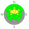
Danger Rose Tutorial
|
There is a Level 1 or Low danger on many slopes this morning, and avalanches are generally unlikely in most areas in the backcountry. Exceptions and heightened avalanche conditions exist on drifted slopes at upper elevations where you could trigger cornice falls and/or shallow wind slab avalanches, and there's a level 2 or Moderate danger in these areas. Warming daytime temperatures will cause an increasing danger of loose wet avalanches on steep slopes as the fresh snow becomes saturated and sticky, and a triggered wet avalanche could entrain a sizable pile of wet surface snow on a sustained pitch... Dangerous deep slab avalanches remain possible on very steep slopes in isolated areas with thin snow coverage, mostly at upper elevations. Evaluate the snow and terrain carefully, and avoid freshly drifted slopes, steep terrain with warming or saturated fresh snow, and upper elevation rocky terrain with shallow snow. |
|
|
CURRENT CONDITIONS |

|
We are applying for a grant to help unify our website, email, SMS, and social media alerts and create an open source platform that could be used by any avalanche center. Check out the link. Click the Like button to vote for the project and spread this among your friends. The grant is awarded based entirely on the number of votes:
http://bit.ly/FRcRsM
|
|
|
RECENT ACTIVITY |

|
No significant avalanche activity was reported in the Logan Zone for well over a week now...
(go to our current conditions page for more details on the local activity and reports of many other recent avalanches and conditions in the backcountry across the mountains of Utah) |
|
|
THREAT #1 |

|
| WHERE |
PROBABILITY |
SIZE |
TREND |

|
|
|
|
| |
|
|
Over the next
24 hours.
|
|
|
Fresh wind slabs formed in exposed upper elevation terrain with Monday's fresh snow and sustained south winds overnight..... You could trigger a wind slab avalanche in steep drifted terrain on the lee side of exposed ridges, or in and around terrain features like gully walls, scoops, cliffs, and sub-ridges. Cornices also built out anew, and some could be fairly sensitive today. Cornices might break further back than you expect, and cornice falls could trigger wind slab avalanches on steep slopes below. |
|
|
THREAT #2 |

|
| WHERE |
PROBABILITY |
SIZE |
TREND |

|
|
|
|
| |
|
|
Over the next
12 hours.
|
|
|
Heightened avalanche conditions will develop again with daytime warming, with triggered loose wet avalanches possible on steep slopes with saturated fresh snow. Dangerous wet slab avalanches failing on moist depth hoar are unlikely but possible on some isolated and very steep slopes, and wet slab avalanches will become more pssible with exceptionally warm mountain temperatures expected tomorrow...... |
|
|
THREAT #3 |

|
| WHERE |
PROBABILITY |
SIZE |
TREND |
|
|
|
|
| |
|
|
Over the next
36 hours.
|
|
|
Depth hoar still plagues the basal snowpack in some areas, and you might trigger a dangerous deep slab avalanche on an isolated steep slope, particularly in areas with generally shallow and weak snow... On some slopes with poor snow structure, an overrunning cornice fall, wind slab, or a smaller wet avalanche might trigger a more dangerous and destructive deep slab avalanche... Exceptionally very warm temperatures tomorrow will increase the creep rate and soften the existing slab layer on some slopes, and free water from melt may lubricate and weaken the weak depth hoar in places, causing the danger to increase... |
|
|
MOUNTAIN WEATHER |

|
We might see some snow showers in the afternoon, but little accumulation is expected today. 8500' high temperatures will climb into the mid 40s, and a southwest wind will sustain 20+ mph averages. We might pick up a couple inches of accumulation overnight, with 2 to 4 inches possible, sustained winds will shift from the northwest, and temperatures should dip a bit below freezing in most mountain areas...Expect temperatures a couple degrees cooler tomorrow with mostly cloudy skies and westerly winds. Things will heat up again Friday and Saturday, with warm overnight temperatures expected. A stronger storm will impact the region late in the coming weekend, with some thunder possible. |
|
|
GENERAL ANNOUNCEMENTS |
I recently published some historical photos of the Huge Wood Camp avalanche from 2-20-1986.... Click HERE
Please consider a donation to your favorite non-profit –The Friends of the Utah Avalanche Center. The Utah Avalanche Center depends on contributions from users like you to support our work.....
Please send us your observations from the backcountry especially if you see or trigger an avalanche, but also even if you don't.. go to avalanche and snow observations. You can also call me directly at 435-757-7578 or leave us a message at our office, 801-524-5304.... And, you can always send us a simple email by clicking HERE
I will update this advisory by around 7:30 in the morning tomorrow. Beginning next week and through much of the month of April, I will update this advisory only intermittently and on weekends...
This advisory is from the U.S.D.A. Forest Service, which is solely responsible for its content. This advisory describes general avalanche conditions and local variations always occur. |
|
|
This information does not apply to developed ski areas or highways where avalanche control is normally done. This advisory is from the U.S.D.A. Forest Service, which is solely responsible for its content. This advisory describes general avalanche conditions and local variations always occur. |
|
This advisory provided by the USDA Forest Service, in partnership with:
The Friends of the Utah Avalanche Center, Utah Division of State Parks and Recreation, Utah Division of Emergency Management, Salt Lake County, Salt Lake Unified Fire Authority and the friends of the La Sal Avalanche Center. See our Sponsors Page for a complete list. |
