SPECIAL ANNOUNCEMENT |
 |
We are applying for a grant to help unify our website, email, SMS, and social media alerts and create an open source platform that could be used by any avalanche center. Check out the link. Click the Like button to vote for the project and spread this among your friends. The grant is awarded based entirely on the number of votes:
http://bit.ly/FRcRsM
|
|
|
BOTTOM LINE
Danger by aspect and elevation on slopes approaching 35° or steeper.
(click HERE for tomorrow's danger rating)
|
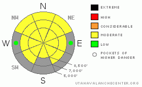
Danger Rose Tutorial
|
Heightened avalanche conditions exist, and there's a level 2 or Moderate danger in the backcountry. Despite cooler temperatures, wind, and cloud cover today, the snow on many slopes is still very saturated, and you could trigger dangerous wet avalanches on very steep slopes. Although now rather unlikely, dangerous deep slab avalanches remain possible on very steep slopes in isolated areas with thin snow coverage. Evaluate the snow and terrain carefully, and avoid very steep terrain with melt-softened saturated snow and upper elevation rocky terrain with thin coverage and persisting poor snow structure. You'll find safer conditions in lower angled terrain and where the wet surface snow is refrozen and supports your weight. |
|
|
CURRENT CONDITIONS |

|
A sustained period with Incredibly warm temperatures and strong south winds has taken it's toll on our snow, and recent melting has been severe... Many access trails, routes, lower elevation and sunny slopes are now burnt off, and others are going quickly. The Tony Grove Snotel reports 39 degrees this morning, and there is 66 inches of total snow at the site, containing 77% of normal water for the date. The Campbell Scientific Logan Peak weather station at 9700' reports a nice and cool 33 degrees, with south winds averaging in the 25 to 30 mph range and a 48 mph gust early this morning... |
|
|
RECENT ACTIVITY |

|
A snow safety team at one of the ski areas near Salt Lake City triggered a large wet slab with explosives on a west facing slope at 9700' yesterday afternoon. The destructive avalanche was reported to be 2 to 3 feet deep and around 100 feet wide...
No significant avalanche activity was reported in the Logan Zone for well over a week now...
(go to our current conditions page for more details on the local activity and reports of many other recent avalanches and conditions in the backcountry across the mountains of Utah) |
|
|
THREAT #1 |

|
| WHERE |
PROBABILITY |
SIZE |
TREND |

|
|
|
|
| |
|
|
Over the next
12 hours.
|
|
|
Heightened avalanche conditions exist and will develop again with daytime warming. Cooler temperatures, cloud cover, and intensifying south winds will help to keep the threat of wet avalanches at bay today, but triggered wet avalanches remain possible in very steep terrain. You might trigger dangerous wet slab avalanches failing on moist depth hoar on some isolated and very steep slopes. |
|
|
THREAT #2 |

|
| WHERE |
PROBABILITY |
SIZE |
TREND |
|
|
|
|
| |
|
|
Over the next
12 hours.
|
|
|
Depth hoar still plagues the basal snowpack in some areas, and you might trigger a dangerous deep slab avalanche on an isolated steep slope, particularly in areas with generally shallow and weak snow... On some slopes with poor snow structure, an overrunning cornice fall or a smaller wet avalanche might trigger a more dangerous and destructive deep slab avalanche... |
|
|
MOUNTAIN WEATHER |

|
Expect a few inches of snow, increasing south-southwest wind, clouds, and much cooler temperatures today, although it will remain well above freezing in the mountains until late tonight. 2 to 4 inches of accumulation is forecast during the day today, and south winds will intensify, with gusts of 50 mph becoming possible. Snow showers will continue into tonight, west winds will gradually diminish into the teens, and temperatures should finally drop into the mid twenties overnight. High pressure will rebuild tomorrow, with mostly sunny skies, light to moderate southwest winds, and temperatures climbing back into the mid forties. A weak and splitting storm will help cool things off again on around Thursday, with a much more potent system passing to the north for the coming weekend.... |
|
|
GENERAL ANNOUNCEMENTS |
I recently published some historical photos of the Huge Wood Camp avalanche from 2-20-1986.... Click HERE
Please consider a donation to your favorite non-profit –The Friends of the Utah Avalanche Center. The Utah Avalanche Center depends on contributions from users like you to support our work.....
Please send us your observations from the backcountry especially if you see or trigger an avalanche, but also even if you don't.. go to avalanche and snow observations. You can also call me directly at 435-757-7578 or leave us a message at our office, 801-524-5304.... And, you can always send us a simple email by clicking HERE
I will update this advisory by around 7:30 in the morning on Mondays, Wednesdays, Fridays, and Saturdays.... Beginning next week and through the month of April, I will update this advisory intermittently and on weekends...
This advisory is from the U.S.D.A. Forest Service, which is solely responsible for its content. This advisory describes general avalanche conditions and local variations always occur. |
|
|
This information does not apply to developed ski areas or highways where avalanche control is normally done. This advisory is from the U.S.D.A. Forest Service, which is solely responsible for its content. This advisory describes general avalanche conditions and local variations always occur. |
|
This advisory provided by the USDA Forest Service, in partnership with:
The Friends of the Utah Avalanche Center, Utah Division of State Parks and Recreation, Utah Division of Emergency Management, Salt Lake County, Salt Lake Unified Fire Authority and the friends of the La Sal Avalanche Center. See our Sponsors Page for a complete list. |
