SPECIAL ANNOUNCEMENT |
 |
We are applying for a grant to help unify our website, email, SMS, and social media alerts and create an open source platform that could be used by any avalanche center. Check out the link. Click the Like button to vote for the project and spread this among your friends. The grant is awarded based on the number of votes:
http://bit.ly/FRcRsM
|
|
|
BOTTOM LINE
Danger by aspect and elevation on slopes approaching 35° or steeper.
(click HERE for tomorrow's danger rating)
|
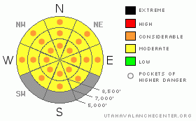
Danger Rose Tutorial
|
Very warm temperatures, green-housing, and direct sun will cause an increasing danger of wet avalanches in the backcountry today. The danger will rise to level 3 or Considerable as the day heats up, and dangerous avalanche conditions will develop on steep slopes with heat-softened and melt-saturated snow. You could trigger wet avalanches, and large natural cornice falls and wet avalanches are also possible. Although now rather unlikely, you still might trigger a dangerous deep slab avalanche on a very steep slope in an isolated area with thin snow coverage. Careful snowpack evaluation, cautious route finding, and conservative decision making will be essential today in the backcountry. |
|
|
CURRENT CONDITIONS |

|
We'll see more sun today, and this morning's supportable snow will get mushy and slow rapidly with way too hot mountain temperatures in the 50s expected again today. I'm expecting pretty strong snow-eating south winds through the weekend. Yesterday, the warm wind helped to keep the veneer surface crust intact in breezy upper elevation terrain, but it is also certainly speeding the melt down. Many access trails, routes, lower elevation and sunny slopes are now burnt off, and others are going quickly. The Tony Grove Snotel reports 39 degrees this morning, and there is 69 inches of total snow at the site, containing 81% of normal water for the date. The Campbell Scientific Logan Peak weather station at 9700' reports 35 degrees and south winds averaging in the 30 mph range this morning, with gusts a bit over 40 mph early this morning... |
|
|
RECENT ACTIVITY |

|
No significant avalanche activity has been reported in the zone for a week or so...
(go to our current conditions page for more details on the local activity and reports of many other recent avalanches and conditions in the backcountry across the mountains of Utah) |
|
|
THREAT #1 |

|
| WHERE |
PROBABILITY |
SIZE |
TREND |

|
|
|
|
| |
|
|
Over the next
12 hours.
|
|
|
Very warm temperatures, green-housing, and direct solar heating will cause the already soggy snow on many slopes to rapidly become saturated and prone to avalanche. Dangerous avalanche conditions will develop. Triggered loose wet sluffs will become increasingly likely in steep terrain as the day heats up.. Loose wet avalanches could entrain large amounts of Monday's snow and pile up deeply, especially below sustained steep slopes. Wet slabs failing on moist depth hoar are possible on isolated very steep slopes with generally shallow snow and poor snow structure. Avoid travel on steep slopes above trees or other terrain traps that you might be swept into, and refrain from loitering in avalanche paths and below steep slopes with saturated snow in the heat of the day... |
|
|
THREAT #2 |

|
| WHERE |
PROBABILITY |
SIZE |
TREND |

|
|
|
|
| |
|
|
Over the next
12 hours.
|
|
|
Sagging cornices are likely to be sensitive in the heat of the day, and some may naturally calve off. Cornices are likely to break further back than expected, and cornice falls could trigger deep slab or wet avalanches on steep slopes below.... |
|
|
THREAT #3 |

|
| WHERE |
PROBABILITY |
SIZE |
TREND |

|
|
|
|
| |
|
|
Over the next
24 hours.
|
|
|
Depth hoar still plagues the basal snowpack in some areas, and you might trigger a dangerous deep slab avalanche on an isolated steep slope, particularly in areas with generally shallow and weak snow... On some slopes with poor snow structure, an overrunning cornice fall or loose wet avalanche might trigger a more dangerous and destructive deep slab avalanche... |
|
|
MOUNTAIN WEATHER |

|
Mostly sunny conditions are expected again today, with mountain high temperatures a bit over 50 degrees and strong south winds. Expect mostly clear conditions overnight, with low temperatures in the mid to upper thirties and gradually diminishing southwest winds. It'll be very warm, sunny, and windy again tomorrow... Our next chance for snow at upper elevations will come Monday, with a couple inches of accumulation likely, and colder temperatures... |
|
|
GENERAL ANNOUNCEMENTS |
I recently published some historical photos of the Huge Wood Camp avalanche from 2-20-1986.... Click HERE
Please consider a donation to your favorite non-profit –The Friends of the Utah Avalanche Center. The Utah Avalanche Center depends on contributions from users like you to support our work.....
Please send us your observations from the backcountry especially if you see or trigger an avalanche, but also even if you don't.. go to avalanche and snow observations. You can also call me directly at 435-757-7578 or leave us a message at our office, 801-524-5304.... And, you can always send us a simple email by clicking HERE
I will update this advisory by around 7:30 in the morning on Mondays, Wednesdays, Fridays, and Saturdays.....
This advisory is from the U.S.D.A. Forest Service, which is solely responsible for its content. This advisory describes general avalanche conditions and local variations always occur. |
|
|
This information does not apply to developed ski areas or highways where avalanche control is normally done. This advisory is from the U.S.D.A. Forest Service, which is solely responsible for its content. This advisory describes general avalanche conditions and local variations always occur. |
|
This advisory provided by the USDA Forest Service, in partnership with:
The Friends of the Utah Avalanche Center, Utah Division of State Parks and Recreation, Utah Division of Emergency Management, Salt Lake County, Salt Lake Unified Fire Authority and the friends of the La Sal Avalanche Center. See our Sponsors Page for a complete list. |
