SPECIAL ANNOUNCEMENT |
|
|
|
BOTTOM LINE
Danger by aspect and elevation on slopes approaching 35° or steeper.
(click HERE for tomorrow's danger rating)
|
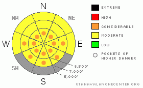
Danger Rose Tutorial
|
Warm temperatures, green-housing, and direct sun will cause an increasing danger of loose wet avalanches today. There is a level 2 or Moderate danger, and heightened avalanche conditions exist in the backcountry around Logan. Conditions will become more dangerous on steep slopes where the fresh snow becomes moist or saturated by daytime warming. I've included several areas with developing level 3 or Considerable danger on most sunny slopes. Wind slab avalanches and cornice falls are possible at upper elevations, and you still might trigger a dangerous deep slab avalanche on a very steep slope in an isolated area with thin snow coverage. Evaluate the snow and terrain carefully, and leave the warming backcountry early today.. At least avoid and stay out from under steep slopes with saturated fresh snow... |
|
|
CURRENT CONDITIONS |

|
The Tony Grove Snotel reports 27 degrees this morning, and there is 77 inches of total snow at the site, containing 84% of normal water for the date. The Campbell Scientific Logan Peak weather station at 9700' reports 23 degrees and west-northwest winds averaging in the lower teens this morning, with overnight average westerly wind speeds near 30 mph for a few hours... |
|
|
RECENT ACTIVITY |

|
In the past couple days there were a couple near misses in the Big Cottonwood and Park City Area in the Salt Lake Zone, with people triggering and getting caught by dangerous hard slab avalanches running on depth hoar. In both cases, the riders luckily escaped..
In the Logan Zone, there were several small naturals and a few manageable triggered wind slabs on Monday, all involving drifted fresh snow... No large or deep avalanches were reported recently.
(go to our current conditions page for more details on the local activity and reports of many other recent avalanches and conditions in the backcountry across the mountains of Utah) |
|
|
THREAT #1 |

|
| WHERE |
PROBABILITY |
SIZE |
TREND |
|
|
|
|
| |
|
|
Over the next
10 hours.
|
|
|
Warm temperatures, green-housing, and direct solar heating will cause the fresh snow on many slopes to rapidly become saturated and prone to avalanche. Triggered loose wet sluffs involving the moist fresh snow will become increasingly likely in steep terrain as the day heats up.. Loose wet avalanches could entrain large amounts of Monday's snow and pile up deeply, especially below sustained steep slopes. Avoid travel on steep slopes above trees or other terrain traps that you might be swept into, and refrain from loitering in avalanche paths and below steep slopes with saturated surface snow in the heat of the day... |
|
|
THREAT #2 |

|
| WHERE |
PROBABILITY |
SIZE |
TREND |

|
|
|
|
| |
|
|
Over the next
24 hours.
|
|
|
Wind slab avalanches are possible in drifted upper elevation terrain. Watch for stiff wind slabs on the lee side of ridges, down wind of smooth low angled fetch areas, and in and around terrain features like gullies, scoops, and cliff bands. Cornices are still likely to be sensitive in some exposed areas. These build quickly this time of year, are likely to break further back than expected, and could trigger wind slab avalanches on steep slopes below..... Avoid drifted fresh snow on steep slopes... |
|
|
THREAT #3 |

|
| WHERE |
PROBABILITY |
SIZE |
TREND |

|
|
|
|
| |
|
|
Over the next
24 hours.
|
|
|
Depth hoar and thin persistent weak layers still plague the basal and mid snowpack in some areas, and you might trigger a dangerous deep slab avalanche on an isolated steep slope, particularly in areas with generally shallow and weak snow... On some slopes with poor snow structure, an overrunning wind slab or loose wet avalanche might trigger a more dangerous and destructive deep slab avalanche... |
|
|
MOUNTAIN WEATHER |

|
Partly sunny conditions are expected today, with mountain high temperatures around 40 degrees and moderate southwest winds, as a dirty ridge of high pressure moves over the area.. Expect mostly clear conditions overnight, with low temperatures in the upper twenties. It'll be a few degrees warmer and mostly sunny again tomorrow... The ridge will shift to the east, and a southerly flow will redevelop across the area, bringing warmer weather for the weekend and the next Pacific storm early next week... |
|
|
GENERAL ANNOUNCEMENTS |
I recently published some historical photos of the Huge Wood Camp avalanche from 2-20-1986.... Click HERE
Please send us your observations from the backcountry especially if you see or trigger an avalanche, but also even if you don't.. go to avalanche and snow observations. You can also call me directly at 435-757-7578 or leave us a message at our office, 801-524-5304.... And, you can always send us a simple email by clicking HERE
I will update this advisory by around 7:30 in the morning on Mondays, Wednesdays, Fridays, and Saturdays.....
This advisory is from the U.S.D.A. Forest Service, which is solely responsible for its content. This advisory describes general avalanche conditions and local variations always occur. |
|
|
This information does not apply to developed ski areas or highways where avalanche control is normally done. This advisory is from the U.S.D.A. Forest Service, which is solely responsible for its content. This advisory describes general avalanche conditions and local variations always occur. |
|
This advisory provided by the USDA Forest Service, in partnership with:
The Friends of the Utah Avalanche Center, Utah Division of State Parks and Recreation, Utah Division of Emergency Management, Salt Lake County, Salt Lake Unified Fire Authority and the friends of the La Sal Avalanche Center. See our Sponsors Page for a complete list. |
