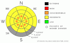
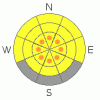
BOTTOM LINE
Danger by aspect and elevation on slopes approaching 35° or steeper.
(click HERE for tomorrow's danger rating)
|
Danger Rose Tutorial
|
There is a level 2 or Moderate danger in the backcountry around Logan. Cold temperatures are helping snow stability and curing the wet avalanche danger, but more than a foot of new snow along with some drifting have created heightened avalanche conditions. I've included pockets with a level 3 or Considerable danger at upper elevations, where some natural avalanches are possible, and you are likely to trigger mostly manageable loose snow sluffs, soft slabs, wind slabs, and cornice falls in steep terrain... Also, you still might trigger a dangerous deep slab avalanche on a very steep slope in an isolated area with thin snow coverage. Careful snowpack evaluation, cautious route finding, and conservative decision making will be essential today in the backcountry. |
|
|
CURRENT CONDITIONS |

|
It might be a good day to call in sick. Overnight temperatures dropped well below freezing, and instead of unconsolidated mush, we should find a nice solid and supportable melt-freeze crust under around a foot of nice fresh powder. The Tony Grove Snotel reports 12 inches of new snow at 8400' in the last 24 hrs, containing 9/10ths of an inch of water. The station reports 17 degreesthis morning, by far, the coldest temperatures in over a week. There's 83 inches of total snow at the site, with 84% of normal water for the date. The Campbell Scientific Logan Peak weather station at 9700' reports 9 degrees and west winds averaging in the teens this morning, with overnight average wind speeds in the 20s... |
|
|
RECENT ACTIVITY |

|
We didn't receive reports of any new avalanches in the Logan Zone from over the weekend....
(go to our current conditions page for more details on the local activity and reports of many other recent avalanches and conditions in the backcountry across the mountains of Utah) |
|
|
THREAT #1 |

|
| WHERE |
PROBABILITY |
SIZE |
TREND |
|
|
|
|
| |
|
|
Over the next
10 hours.
|
|
|
Triggered loose sluffs and mostly manageable soft slabs involving the new snow are likely in steep upper elevation terrain. Be especially cautious if you travel on steep slopes above trees or other terrain traps that you might be swept into. Natural new snow avalanches are possible, and most likely during periods with especially high rates of snowfall or winds. So, pay attention to what is above you, and avoid loitering in avalanche paths and below steep slopes... |
|
|
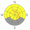
THREAT #2 |

|
| WHERE |
PROBABILITY |
SIZE |
TREND |
|
|
|
|
| |
|
|
Over the next
24 hours.
|
|
|
Wind slab avalanches are possible in drifted terrain, and today's west and northwesterly winds will increase the size of potential wind slabs and make the threat become more widespread... Watch for fresh and developing wind slabs on the lee side of ridges, down wind of smooth low angled fetch areas, and in and around terrain features like gullies, scoops, and cliff bands. Cornices are likely to be sensitive in some exposed areas. These build quickly this time of year, are likely to break further back than expected, and could trigger wind slab avalanches on steep slopes below..... Avoid drifted fresh snow on steep slopes... |
|
|
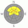
THREAT #3 |

|
| WHERE |
PROBABILITY |
SIZE |
TREND |
|
|
|
|
| |
|
|
Over the next
24 hours.
|
|
|
Depth hoar and thin persistent weak layers still plague the basal and mid snowpack in some areas, and you might trigger a dangerous deep slab avalanche on an isolated steep slope, particularly in areas with generally shallow and weak snow... |
|
|
MOUNTAIN WEATHER |

|
Expect snow showers today, with 5 to 9 inches of additional accumulation forecast and fairly sustained west winds in the 15 to 20+ mph range along the ridges. Temperatures will be cold in the mountains tonight, with snow showers possible, and a low temperature of around 15 degrees forecast for 8500'. Partly sunny conditions are expected tomorrow with mountain high temperatures still below freezing and moderate southwest winds, as a dirty ridge of high pressure moves over the area.... |
|
|
GENERAL ANNOUNCEMENTS |
I recently published some historical photos of the Huge Wood Camp avalanche from 2-20-1986.... Click HERE
Please consider a donation to your favorite non-profit –The Friends of the Utah Avalanche Center. The Utah Avalanche Center depends on contributions from users like you to support our work.....
Please send us your observations from the backcountry especially if you see or trigger an avalanche, but also even if you don't.. go to avalanche and snow observations. You can also call me directly at 435-757-7578 or leave us a message at our office, 801-524-5304.... And, you can always send us a simple email by clicking HERE
I will update this advisory by around 7:30 in the morning on Mondays, Wednesdays, Fridays, and Saturdays.....
This advisory is from the U.S.D.A. Forest Service, which is solely responsible for its content. This advisory describes general avalanche conditions and local variations always occur. |
|
|
This information does not apply to developed ski areas or highways where avalanche control is normally done. This advisory is from the U.S.D.A. Forest Service, which is solely responsible for its content. This advisory describes general avalanche conditions and local variations always occur. |
|
This advisory provided by the USDA Forest Service, in partnership with:
The Friends of the Utah Avalanche Center, Utah Division of State Parks and Recreation, Utah Division of Emergency Management, Salt Lake County, Salt Lake Unified Fire Authority and the friends of the La Sal Avalanche Center. See our Sponsors Page for a complete list. |
