BOTTOM LINE
Danger by aspect and elevation on slopes approaching 35° or steeper.
(click HERE for tomorrow's danger rating)
|
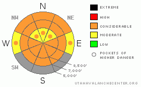
Danger Rose Tutorial
|
Clouds, wind, and snow should help keep the snow surface cool and solid, but a prolonged warm period without freezing temperatures overnight has created dangerous avalanche conditions. There's a level 3 or Considerable danger in the backcountry, and the danger will rise again as saturated snow softens with daytime heating. It is likely that you will trigger a dangerous wet avalanche if you venture on steep slopes with melt softened saturated snow. Natural wet avalanches and cornice falls are possible, and you still could trigger a dangerous deep slab avalanche up to several feet deep, especially in upper elevation areas with thin coverage. Careful snowpack evaluation, cautious route finding, and conservative decision making will be essential once again today in the backcountry. |
|
|
CURRENT CONDITIONS |

|
You'll find very moist or saturated snow conditions, with only a superficial veneer crust in the morning, since overnight temperatures stayed well above freezing again. Lower and mid elevation slopes and meadows are now easily softened by the daytime warming, and you can easily get mired down and stuck in the muck if you venture off the beaten path. Upper elevation slopes could remain crusty and supportable with cloud cover and southwest wind today. The 8400' Tony Grove Snotel reports a steamy 38 degrees this morning. There's 71 inches of total snow at the site, containing 84% of normal water for the date. The Campbell Scientific Logan Peak weather station at 9700' reports a much cooler 28 degrees and south-southeast winds averaging over 40 mph this morning, with a gust of 66 mph during an early morning squall. |
|
|
RECENT ACTIVITY |

|
The Logan Zone has seen a good number of natural wet avalanches in recent days, and we found a couple fresh wet deep slab avalanches yesterday on the east side of Red Pine Ridge. The large and scary full depth avalanches were triggered by overrunning wet sluffs coming out of rocks above. HERE
There were a couple close calls last week, in which riders triggered dangerous deep slab avalanches. In one case, a couple riders amazingly emerged unscathed from a very large hard slab they triggered on the east side of Double Top Mountain on Thursday 3-8-2012.. I went up to take a look on Wednesday and updated the report.... posted HERE
(go to our current conditions page for more details on the local activity and reports of many other recent avalanches and conditions across the mountains of Utah) |
|
|
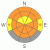
THREAT #1 |

|
| WHERE |
PROBABILITY |
SIZE |
TREND |
|
|
|
|
| |
|
|
Over the next
10 hours.
|
|
|
Wet avalanches will again become more likely during the heat of midday, and you should avoid steep slopes with melt-softened saturated snow. Mountain overnight temperatures are not dropping below freezing, in many cases remaining well above. Without a good refreeze, we'll find only a thin veneer crust on the surface in the mornings, and this will rapidly deteriorate. With now saturated weak layers, generally poor snow structure, and a weakening slab, dangerous wet slab avalanches are possible, especially on steep slopes with generally shallow snow cover. Cloud cover and southwest winds may help to keep upper elevation slopes cool, but areas that are more sheltered from the winds and mid and lower elevation slopes will heat up and soften up pretty quickly this morning... Rain today at lower and mid elevations could make conditions more dangerous |
|
|
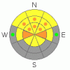
THREAT #2 |

|
| WHERE |
PROBABILITY |
SIZE |
TREND |
|
|
|
|
| |
|
|
Over the next
24 hours.
|
|
|
A loose wet avalanche overrunning a slope with poor snow structure could cause the avalanche to step down into deeply buried weak layers or the ground.. Depth hoar and thin persistent weak layers still plague the basal and mid snowpack in many areas, and you might trigger a dangerous deep slab avalanche, particularly in areas with generally shallow and weak snow...Avoid shallow or rocky terrain at upper and mid elevations, and keep in mind that you are most likely to trigger a very dangerous deep slab avalanche from an area where the slab layer is relatively thin. Deep slab avalanches up to around 3 feet deep may be quite easy to initiate in some areas, and you might trigger one remotely, from a distance, or worse from below. More likely, they'll be quite stubborn, not releasing until you hit the so called "sweet spot", which could occur even though a slope already has many tracks in it... |
|
|
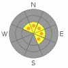
THREAT #3 |

|
| WHERE |
PROBABILITY |
SIZE |
TREND |
|
|
|
|
| |
|
|
Over the next
24 hours.
|
|
|
You should avoid the big warmth softened cornices along exposed upper elevation ridges. A cornice fall could trigger a large avalanche on steep slopes below. |
|
|
MOUNTAIN WEATHER |

|
Expect 8500' high temperatures of around 43 and sustained strong southwest winds as a Pacific storm approaches the area today. Clouds and snow are likely, with 1 to 3 inches of accumulation expected at upper elevations. Rain is likely below around 8000'... Southwest winds will continue tonight with 2 to 4 more inches of snow at upper elevations and a low temperature only a bit below freezing. Snowfall should continue through Monday, with a couple inches possible tomorrow and several more tomorrow night. Temperatures should finally drop well below below freezing, for the first time in around a week, on Sunday night. |
|
|
GENERAL ANNOUNCEMENTS |
I recently published some historical photos of the Huge Wood Camp avalanche from 2-20-1986.... Click HERE
Please consider a donation to your favorite non-profit –The Friends of the Utah Avalanche Center. The Utah Avalanche Center depends on contributions from users like you to support our work.....
Please send us your observations from the backcountry especially if you see or trigger an avalanche, but also even if you don't.. go to avalanche and snow observations. You can also call me directly at 435-757-7578 or leave us a message at our office, 801-524-5304.... And, you can always send us a simple email by clicking HERE
I will update this advisory by around 7:30 in the morning on Mondays, Wednesdays, Fridays, and Saturdays.....
This advisory is from the U.S.D.A. Forest Service, which is solely responsible for its content. This advisory describes general avalanche conditions and local variations always occur. |
|
|
This information does not apply to developed ski areas or highways where avalanche control is normally done. This advisory is from the U.S.D.A. Forest Service, which is solely responsible for its content. This advisory describes general avalanche conditions and local variations always occur. |
|
This advisory provided by the USDA Forest Service, in partnership with:
The Friends of the Utah Avalanche Center, Utah Division of State Parks and Recreation, Utah Division of Emergency Management, Salt Lake County, Salt Lake Unified Fire Authority and the friends of the La Sal Avalanche Center. See our Sponsors Page for a complete list. |
