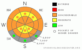
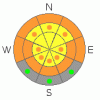
BOTTOM LINE
Danger by aspect and elevation on slopes approaching 35° or steeper.
(click HERE for tomorrow's danger rating)
|
Danger Rose Tutorial
|
The overall danger will rise to level 3 or Considerable as saturated snow softens with daytime heating. It is likely that you will trigger a dangerous wet avalanche if you play around on slopes steeper than about 37 degrees with saturated and melt softened snow. Natural wet avalanches and cornice falls are possible, and you still could trigger a dangerous deep slab avalanche up to several feet deep, especially in upper elevation areas with thin coverage. Careful snowpack evaluation, cautious route finding, and conservative decision making will be essential today in the backcountry. |
|
|
CURRENT CONDITIONS |

|
You'll find very moist or saturated snow conditions, with only a superficial veneer crust in the morning, since overnight temperatures stayed well above freezing and cloud cover trapped yesterday's warmth in the atmosphere.. The 8400' Tony Grove Snotel reports 37 degrees this morning. There's 75 inches of total snow at the site, containing 86% of normal water for the date. The Campbell Scientific Logan Peak weather station at 9700' reports a cool 30 degrees and west-southwest winds averaging around 25 mph this morning after posting average wind speeds in the thirties for much of yesterday. |
|
|
RECENT ACTIVITY |

|
There were a couple close calls last week, in which riders triggered dangerous deep slab avalanches. I checked out a rider triggered hard slab avalanche in the Rodeo Grounds on the east side of Logan Peak , and a couple riders amazingly emerged unscathed from a very large hard slab they triggered on the east side of Double Top Mountain (otherwise known as Gun Sight) on Thursday 3-8-2012...
Otherwise, we haven't received reports of any new avalanches for a few days.
(go to our current conditions page for more details on the local activity and reports of many other recent avalanches and conditions across the mountains of Utah) |
|
|
THREAT #1 |

|
| WHERE |
PROBABILITY |
SIZE |
TREND |
|
|
|
|
| |
|
|
Over the next
10 hours.
|
|
|
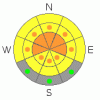
Wet avalanches will again become more likely during the heat of midday, and you should avoid steep slopes with melt-softened saturated snow. Mountain overnight temperatures are not dropping below freezing, in many cases remaining well above. Without a good refreeze, we'll find only a thin veneer crust on the surface in the mornings, and this will rapidly deteriorate. With now saturated weak layers, generally poor snow structure, and a weakening slab, dangerous wet slab avalanches are possible, especially on steep slopes with generally shallow snow cover. |
|
|
THREAT #2 |

|
| WHERE |
PROBABILITY |
SIZE |
TREND |
|
|
|
|
| |
|
|
Over the next
10 hours.
|
|
|
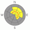
Depth hoar and thin persistent weak layers still plague the basal and mid snowpack in many areas, and you might trigger a dangerous deep slab avalanche, particularly in areas with generally shallow and weak snow...Avoid shallow or rocky terrain at upper and mid elevations, and keep in mind that you are most likely to trigger a very dangerous deep slab avalanche from an area where the slab layer is relatively thin. Deep slab avalanches up to around 3 feet deep may be quite easy to initiate in some areas, and you might trigger one remotely, from a distance, or worse from below. More likely, they'll be quite stubborn, not releasing until you hit the so called "sweet spot", which could occur even though a slope already has many tracks in it... |
|
|
THREAT #3 |

|
| WHERE |
PROBABILITY |
SIZE |
TREND |
|
|
|
|
| |
|
|
Over the next
24
hours.
|
|
|
Cornices will sag and become more sensitive with midday warmth, and some may naturally calve-off. A cornice fall could trigger a dangerous hard or wet slab avalanche on a steep slope below.... |
|
|
MOUNTAIN WEATHER |

|
Looks like mild and breezy weather will continue through the week, with above normal temperatures. Disturbances will pass to the north, bringing warm temperatures, winds, cloudiness, and a chance for a little snow, but not much in the way of accumulation... Expect 8500' high temperatures of around 41 today, with increasing clouds and snow showers in the afternoon.. It will be cloudy and warm again tonight and a few degrees warmer tomorrow. A few inches of accumulation are possible on Friday in the Logan Zone as a snow producing cold front will track over southern Idaho. Looks like a stronger storm for Saturday night and Sunday, with high pressure returning next week. |
|
|
GENERAL ANNOUNCEMENTS |
Please consider a donation to your favorite non-profit –The Friends of the Utah Avalanche Center. The Utah Avalanche Center depends on contributions from users like you to support our work.....
Please send us your observations from the backcountry especially if you see or trigger an avalanche, but also even if you don't.. go to avalanche and snow observations. You can also call me directly at 435-757-7578 or leave us a message at our office, 801-524-5304.... And, you can always send us a simple email by clicking HERE
I will update this advisory by around 7:30 in the morning on Mondays, Wednesdays, Fridays, and Saturdays.....
This advisory is from the U.S.D.A. Forest Service, which is solely responsible for its content. This advisory describes general avalanche conditions and local variations always occur. |
|
|
This information does not apply to developed ski areas or highways where avalanche control is normally done. This advisory is from the U.S.D.A. Forest Service, which is solely responsible for its content. This advisory describes general avalanche conditions and local variations always occur. |
|
This advisory provided by the USDA Forest Service, in partnership with:
The Friends of the Utah Avalanche Center, Utah Division of State Parks and Recreation, Utah Division of Emergency Management, Salt Lake County, Salt Lake Unified Fire Authority and the friends of the La Sal Avalanche Center. See our Sponsors Page for a complete list. |
