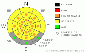
BOTTOM LINE
Danger by aspect and elevation on slopes approaching 35° or steeper.
(click HERE for tomorrow's danger rating)
|
Danger Rose Tutorial
|
Heightened avalanche conditions exist in the backcountry and there is a level 2 or Moderate danger. The danger will rise with daytime heating, avalanches will become more likely, and I've added several pockets of level 3 or Considerable danger to the rose. You might trigger a large and dangerous deep slab avalanche up to 3 feet deep in some areas, most likely on a very steep upper elevation slope in an outlying area with poor snow structure and generally thin snow coverage... Wet sluffs and/or slab avalanches will become increasingly possible with the midday heat once again, and cornice falls might trigger large avalanches on steep slopes below. Evaluate the snow and terrain carefully, and continue to avoid steep rocky slopes with generally thin snow cover, steep slopes with melt softened wet snow, and large ridge-top cornices. You'll find safer conditions in sheltered shady areas, at lower elevations, and in lower angled terrain... |
|
|
CURRENT CONDITIONS |

|
Mountain temperatures finally dropped below freezing overnight, most only by a couple degrees... This refreeze, some cloud cover, and a continuing west-southwest breeze will help keep the saturated snow from getting too soft. The 8400' Tony Grove Snotel reports 30 degrees this morning and an inch of new snow overnight containing 1/10th of an inch of water. There's 78 inches of total snow at the site, containing 87% of normal water for the date. The Campbell Scientific Logan Peak weather station at 9700' reports a cool 24 degrees and west-southwest winds averaging in the teens this morning after posting average wind speeds in the mid twenties for several hours overnight... |
|
|
RECENT ACTIVITY |

|
At least a couple sizable natural avalanches occurred in the Central Wasatch Range near Salt Lake City over the weekend, and a snow biker triggered a fairly large slide in the Ant knolls to the south... No new avalanches were reported from the Utah backcountry yesterday. Locally; I checked out a rider triggered hard slab avalanche in the Rodeo Grounds on the east side of Logan Peak on Thursday, and despite a busy and sweltering weekend, we haven't received reports of any new avalanches
(go to our current conditions page for more details on the local activity and reports of many other recent avalanches and conditions across the mountains of Utah) |
|
|
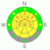
THREAT #1 |

|
| WHERE |
PROBABILITY |
SIZE |
TREND |
|
|
|
|
| |
|
|
Over the next
10 hours.
|
|
|
Depth hoar and thin persistent weak layers still plague the basal and mid snowpack in many areas, and you might trigger a dangerous deep slab avalanche, particularly in areas with generally shallow and weak snow...Avoid shallow or rocky terrain at upper and mid elevations, and keep in mind that you are most likely to trigger a very dangerous deep slab avalanche from an area where the slab layer is relatively thin. Deep slab avalanches up to around 3 feet deep may be quite easy to initiate in some areas, and you might trigger one remotely, from a distance, or worse from below. More likely, they'll be quite stubborn, not releasing until you hit the so called "sweet spot", which could occur even though a slope already has many tracks in it... |
|
|
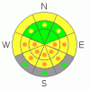
THREAT #2 |

|
| WHERE |
PROBABILITY |
SIZE |
TREND |
|
|
|
|
| |
|
|
Over the next
10 hours.
|
|
|
Wet sluffs and slab avalanches will become more likely during the heat of midday, and you should get off of and avoid steep slopes with melt-softened saturated snow. It's a good idea to stay out of gullies or other terrain features under steep sunny slopes |
|
|
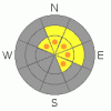
THREAT #3 |

|
| WHERE |
PROBABILITY |
SIZE |
TREND |
|
|
|
|
| |
|
|
Over the next
24
hours.
|
|
|
Cornices will sag and become more sensitive with midday warmth, and some may naturally calve-off. A cornice fall could trigger a dangerous hard or wet slab avalanche on a steep slope below.... |
|
|
MOUNTAIN WEATHER |

|
Looks like mild and breezy weather will continue through the week, with above normal temperatures. Disturbances will pass to the north, bringing winds, some cloudiness and a chance for a little snow, but not much in the way of accumulation... Expect 8500' high temperatures around 42 today.... Winds will increase overnight and be on the stronger side tomorrow, with temperatures climbing into the mid forties and southwest ridge-top winds averaging around 30 mph, with gusts in the 40s. Our next hope for a snow producing storm will come over the weekend, but models disagree on timing and potency at this point. |
|
|
GENERAL ANNOUNCEMENTS |
Please consider a donation to your favorite non-profit –The Friends of the Utah Avalanche Center. The Utah Avalanche Center depends on contributions from users like you to support our work.....
Please send us your observations from the backcountry especially if you see or trigger an avalanche, but also even if you don't.. go to avalanche and snow observations. You can also call me directly at 435-757-7578 or leave us a message at our office, 801-524-5304.... And, you can always send us a simple email by clicking HERE
I will update this advisory by around 7:30 in the morning on Mondays, Wednesdays, Fridays, and Saturdays.....
This advisory is from the U.S.D.A. Forest Service, which is solely responsible for its content. This advisory describes general avalanche conditions and local variations always occur. |
|
|
This information does not apply to developed ski areas or highways where avalanche control is normally done. This advisory is from the U.S.D.A. Forest Service, which is solely responsible for its content. This advisory describes general avalanche conditions and local variations always occur. |
|
This advisory provided by the USDA Forest Service, in partnership with:
The Friends of the Utah Avalanche Center, Utah Division of State Parks and Recreation, Utah Division of Emergency Management, Salt Lake County, Salt Lake Unified Fire Authority and the friends of the La Sal Avalanche Center. See our Sponsors Page for a complete list. |
