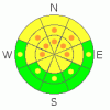
BOTTOM LINE
Danger by aspect and elevation on slopes approaching 35° or steeper.
(click HERE for tomorrow's danger rating)
|

Danger Rose Tutorial
|
Cold temperatures are helping snow stability and there's a level 2 or Moderate danger in the backcountry around Logan today. You could still trigger large and dangerous deep slab avalanches in isolated outlying areas and steep upper and mid elevation slopes with generally thin snow coverage... I've included some pockets of level 3 or Considerable danger on suspect slopes, because any triggered deep slab could be huge, destructive, and quite likely unsurvivable... Fresh shallow and generally manageable wind slab avalanches are likely on recently drifted slopes, and you should be aware of trees or other terrain traps below you if you travel in steep terrain. Cornice falls could trigger large slab avalanches on steep drifted slopes below. Evaluate the snow and terrain carefully, and continue to avoid steep rocky slopes with generally thin snow cover. You'll find safer conditions at lower elevations, on slopes with a solidly refrozen sun-crust, in sheltered areas, and in lower angled terrain... |
|
|
CURRENT CONDITIONS |

|
Temperatures dropped significantly with yesterday evening's blustery cold front and the resulting refreeze will lock up the saturated snow on sunny slopes and solidify the widespread sun-crust. Not much in the way of accumulation, with remote snow sites in the Bear River Range only reporting 2 to 4 inches, so expect to find fast, dust-on-crust conditions. It's 20 degrees up at the 8400' Tony Grove Snotel this morning, and there's 86 inches of total snow containing 91% of normal water for the date. The site picked up 3 new inches of snow overnight, containing 2/10ths of an inch of water... The 9700' Campbell Scientific Logan Peak weather station reports 12 crispy degrees, and a northeast wind averaging around 15 mph this morning... Cooler temperatures will help with snow stability.... |
|
|
RECENT ACTIVITY |

|
It was a very active weekend across the mountains of northern Utah, with numerous large natural and some scary human triggered avalanches reported from the backcountry.... On Saturday, a snowmobiler was deeply buried and killed by a large avalanche in a very remote area in the La Sal Range in the Moab Area. Max Forgensi of the Utah Avalanche Center was on scene and compiled an excellent accident report.... HERE
Sledders recovered a party member who was completely buried under several feet of heavy avalanche debris in the mountains near Kamas on Sunday. For an excellent video recounting the miracle rescue, click... HERE
Locally; the warmth and sunshine on Sunday and Monday caused a good number of large avalanches in the Logan Zone.... On Friday in the Providence Canyon Area, while walking on the windward side of Red Pine Ridge at around 9000' in elevation, we remote triggered a small cornice fall that triggered a very large hard slab on the slope below. The avalanche on a mostly east facing slope caused another large sympathetic release a few hundred feet away. The deep slab avalanche failed on weak faceted December snow or depth hoar near the ground.
(go to our current conditions page for more details on the local activity and reports of many other recent avalanches and conditions across the mountains of Utah) |
|
|
THREAT #1 |

|
| WHERE |
PROBABILITY |
SIZE |
TREND |
|
|
|
|
| |
|
|
Over the next
24 hours.
|
|
|
Depth hoar still plagues the basal layers of the snowpack in many areas, and you might trigger a dangerous deep slab avalanche on a steep slope facing the northern half of the compass, particularly in areas with generally shallow and weak snow... It is possible that a cornice fall, or a smaller wind slab avalanche overrunning a slope with poor snow structure could cause a much larger and more dangerous deep slab avalanche. Avoid shallow or rocky terrain at upper and mid elevations, and keep in mind that you are most likely to trigger a very dangerous deep slab avalanche from an area where the slab layer is relatively thin. There are also a couple other buried persistent weak layers to be concerned with, consisting of notoriously persistent feathery frost crystals or surface hoar and small sugary grains called near surface facets. Deep slab avalanches 3 or 4 feet deep may still be quite easy to initiate in some areas, and you might trigger one remotely, from a distance, or worse from below. |
|
|
THREAT #2 |

|
| WHERE |
PROBABILITY |
SIZE |
TREND |
|
|
|
|
| |
|
|
Over the next
10 hours.
|
|
|
You'll probably find a few fresh wind slabs on the lee sides of major ridge lines and in and around terrain features like sub-ridges, gullies, scoops, and cliff bands. Avoid drifted snow on steep slopes, and be aware of trees or other terrain traps below you. The colder temperatures should help to hold together the large ridge top cornices, but some may have built up anew with last night's snow and wind. Some may be sensitive to your weight, and they are likely to break further back from the edge than you might expect. Cornice-falls could trigger large slab avalanches on steep drifted slopes below.. . |
|
|
MOUNTAIN WEATHER |

|
A few snow showers are likely this morning, and there will be a chilly north wind along the ridges today, with 8500' high temperatures only in the mid twenties... Moderate northeast winds will continue tonight, with low temperatures in the mid teens. A high pressure system will set up over the region on Thursday. Expect gradually warming and dry, fair weather in the mountains through at least early next week... |
|
|
GENERAL ANNOUNCEMENTS |
Please consider a donation to your favorite non-profit –The Friends of the Utah Avalanche Center. The Utah Avalanche Center depends on contributions from users like you to support our work.....
Please send us your observations from the backcountry especially if you see or trigger an avalanche, but also even if you don't.. go to avalanche and snow observations. You can also call me directly at 435-757-7578 or leave us a message at our office, 801-524-5304.... And, you can always send us a simple email by clicking HERE
I will update this advisory by around 7:30 in the morning on Mondays, Wednesdays, Fridays, and Saturdays.....
This advisory is from the U.S.D.A. Forest Service, which is solely responsible for its content. This advisory describes general avalanche conditions and local variations always occur. |
|
|
This information does not apply to developed ski areas or highways where avalanche control is normally done. This advisory is from the U.S.D.A. Forest Service, which is solely responsible for its content. This advisory describes general avalanche conditions and local variations always occur. |
|
This advisory provided by the USDA Forest Service, in partnership with:
The Friends of the Utah Avalanche Center, Utah Division of State Parks and Recreation, Utah Division of Emergency Management, Salt Lake County, Salt Lake Unified Fire Authority and the friends of the La Sal Avalanche Center. See our Sponsors Page for a complete list. |
