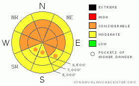
BOTTOM LINE
Danger by aspect and elevation on slopes approaching 35° or steeper.
(click HERE for tomorrow's danger rating)
|
Danger Rose Tutorial
|
Dangerous avalanche conditions currently exist on many upper and mid elevation slopes, and there is a level 3 or Considerable danger in the backcountry.. Dangerous and destructive deep slab avalanches are likely in some places, especially in areas with a generally thin snowpack... Cornices may break further back than expected, and cornice falls could trigger very large avalanches on steep slopes below.. Careful snowpack evaluation, cautious route finding, and conservative decision making will be essential today in the backcountry. You'll find safer conditions in sheltered shady areas, and on lower angled slopes... |
|
|
CURRENT CONDITIONS |

|
It's a balmy 34 degrees up at the 8400' Tony Grove Snotel this morning, and there's 84 inches of total snow containing 91% of normal water for the date. The Campbell Scientific Logan Peak weather station at 9700' reports 26 degrees, and southwest winds overnight, with 30+ mph hourly averages for several hours. Cloud cover, a continuing southwest wind, and cooler temperatures should help with snow stability.... |
|
|
RECENT ACTIVITY |

|
It was a very activeweekend across the mountains of northern Utah, with numerous large natural and some scary human triggered avalanches reported from the backcountry.... On Saturday, a snowmobiler was deeply buried and killed by a large avalanche in a very remote area in the La Sal Range in the Moab Area. Max Forgensi of the Utah Avalanche Center was on scene yesterday and compiled an excellent accident report.... HERE
Locally; the warmth and sunshine on Sunday and again yesterday caused several large natural and maybe a couple triggered avalanches in the zone. On Friday, we remote triggered a small cornice fall from about 30' to the windward while walking along the ridge, which triggered a very large hard slab, 4 to 6' deep and maybe 500' wide. This in turn caused another wider pocket a few hundred feet north to sympathetic 2' to 3' deep and 800' wide.. This on a mostly east facing slope at around 9000' in elevation. The avalanche ran on faceted December snow or depth hoar near the ground. This occurred in White Rock Hollow, which we accessed from the Middle Fork of Providence Canyon. While investigating the avalanche I triggered a bit of hang-fire, which almost caught me. Thankfully, I was able to ski clear of the slab as it broke above and all around me......
(go to our current conditions page for more details on local activity and reports of other recent avalanches in Utah) |
|
|
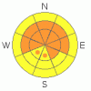
THREAT #1 |

|
| WHERE |
PROBABILITY |
SIZE |
TREND |
|
|
|
|
| |
|
|
Over the next
24 hours.
|
|
|
Depth hoar still plagues the basal layers of the snowpack in many areas, and it appears that in some areas this week's accumulation and wind drifting was enough to reactive the dragon. You might trigger a dangerous deep slab avalanche on a steep slope facing the northern half of the compass, particularly in areas with generally shallow and weak snow... It is possible that a cornice fall, or a smaller avalanche overrunning a slope with poor snow structure could cause a much larger and more dangerous deep slab avalanche. Avoid shallow or rocky terrain at upper and mid elevations, and keep in mind that you are most likely to trigger a very dangerous deep slab avalanche from an area where the slab layer is relatively thin.
Another persistent weak layer consisting of feathery surface hoar crystals and small sugary near surface facet grains was well preserved by light snow and little wind in early February, and observers identified another similar thin persistent weak layer above this in some areas. Today, unmanageable slab avalanches failing on buried persistent weak layers are likely to be 2 to 6 feet deep. Deep slab avalanches may be quite sensitive in some areas, and you might trigger one remotely, from a distance, or worse from below. |
|
|
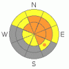
THREAT #2 |

|
| WHERE |
PROBABILITY |
SIZE |
TREND |
|
|
|
|
| |
|
|
Over the next
10 hours.
|
|
|
Windy conditions overnight and today will further build cornices in exposed areas. Overhanging ridge-top cornices were greatly enlarged by last week's wind and some may still be hair trigger sensitive or stubborn and tricky, and they are likely to break further back from the edge than you might expect. Cornice-falls are likely to trigger potentially large slab avalanches on steep drifted slopes below... Also, you'll probably find a few stiff and stubborn wind slabs on the lee sides of major ridge lines and in and around terrain features like sub-ridges, gullies, scoops, and cliff bands. |
|
|
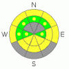
THREAT #3 |

|
| WHERE |
PROBABILITY |
SIZE |
TREND |
|
|
|
|
| |
|
|
Over the next
10 hours.
|
|
|
Wet avalanches will again be possible at lower an mid elevations with potential for greenhouse type warming today, especially if the sun peeks out this morning. Avoid steep slopes with moist or saturated and soft surface snow... Roller balls, pin wheels, and loose wet avalanches are all signs of instability... |
|
|
MOUNTAIN WEATHER |

|
Expect cloudy and windy conditions today, with a couple inches of accumulation probable and westerly winds. The southern split of today's storm will send the bulk of the energy well to our south, but we'll still see a few more inches of snow and continued northwest winds overnight. The weather will remain unsettled through Wednesday and a high pressure system will set up over the region on Thursday. Expect warmer and dry weather through early next week... |
|
|
GENERAL ANNOUNCEMENTS |
Please consider a donation to your favorite non-profit –The Friends of the Utah Avalanche Center. The Utah Avalanche Center depends on contributions from users like you to support our work.....
Please send us your observations from the backcountry especially if you see or trigger an avalanche, but also even if you don't.. go to avalanche and snow observations. You can also call me directly at 435-757-7578 or leave us a message at our office, 801-524-5304.... And, you can always send us a simple email by clicking HERE
I will update this advisory by around 7:30 in the morning on Mondays, Wednesdays, Fridays, and Saturdays.....
This advisory is from the U.S.D.A. Forest Service, which is solely responsible for its content. This advisory describes general avalanche conditions and local variations always occur. |
|
|
This information does not apply to developed ski areas or highways where avalanche control is normally done. This advisory is from the U.S.D.A. Forest Service, which is solely responsible for its content. This advisory describes general avalanche conditions and local variations always occur. |
|
This advisory provided by the USDA Forest Service, in partnership with:
The Friends of the Utah Avalanche Center, Utah Division of State Parks and Recreation, Utah Division of Emergency Management, Salt Lake County, Salt Lake Unified Fire Authority and the friends of the La Sal Avalanche Center. See our Sponsors Page for a complete list. |
