AVALANCHE WARNING »
Dangerous avalanche conditions are occuring or are imminent.
Backcountry travel in avalanche terrain is not recommended.
|
 |
Notice: RAPID WARMING AND DIRECT SUN WILL CREATE DANGEROUS AND UNSTABLE AVALANCHE CONDITIONS. NATURAL AND HUMAN TRIGGERED AVALANCHES ARE LIKELY. BACKCOUNTRY TRAVEL ON OR BELOW STEEP MOUNTAIN SLOPES IS NOT RECOMMENDED OVER THE NEXT FEW DAYS. |
|
|
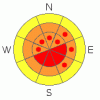
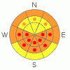
BOTTOM LINE
Danger by aspect and elevation on slopes approaching 35° or steeper.
(click HERE for tomorrow's danger rating)
|
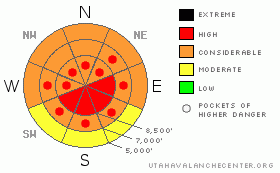
Danger Rose Tutorial
|
Warming and direct sun will cause a level 4 or HIGH danger in the backcountry today... Dangerous avalanche conditions currently exist on many upper and mid elevation slopes, and solar warning will make triggering avalanches easier for people and large natural avalanches possible. In some areas, new snow and significant drifting last week overloaded and reactivated deeply buried weak layers. Dangerous and destructive triggered deep slab avalanches are likely in some places, especially in areas with a generally thin snowpack... Cornices may be very sensitive and are likely to break further back than expected, and cornice falls could trigger very large avalanches on steep slopes below... Warmth and sun will cause a developing danger of wet avalanches on steep slopes with saturated snow. Avoid and stay out from under steep slopes and obvious or historic avalanche paths, especially during the heat of midday, and it's time to leave the area if the snow you're on becomes damp or saturated... You'll find safer conditions in sheltered shady areas, and on lower angled slopes... |
|
|
CURRENT CONDITIONS |

|
It's already 27 degrees up at the 8400' Tony Grove Snotel this morning. There is now 91 inches of total snow on the ground containing 91% of normal water for the date. The station reported some water accumulation from freezing rain or rime yesterday afternoon. The Campbell Scientific Logan Peak weather station at 9700' reports 20 degrees, and northwest winds diminished to single digit hourly averages overnight. The wind was much stronger at the Hwy 89 Logan Summit UDOT sheds, with sustained hourly average windspeeds overnight in the mid twenties and gusts in the thirties... |
|
|
RECENT ACTIVITY |

|
It was another active day yesterday across the mountains of northern Utah, with numerous human triggered avalanches reported from the backcountry... A skier was caught and completely buried in the Central Wasatch Range, but his partners quickly rescued him and he was uninjured and able ski out on his own... The search continues today in the La Sal Range near Moab for a missing snowmobiler who presumably remains buried in a deep pile of debris from a large avalanche... His sled was located just before dark yesterday, buried under around 12' of heavy snow, which was deeply piled in a gully at the bottom of the avalanche.
On Friday, we remote triggered a small cornice fall from about 30' to the windward while walking along the ridge, which triggered a very large hard slab, 4 to 6' deep and maybe 500' wide. This in turn caused another wider pocket a few hundred feet north to sympathetic 2' to 3' deep and 800' wide.. This on a mostly east facing slope at around 9000' in elevation. The avalanche ran on faceted December snow or depth hoar near the ground. This occurred in White Rock Hollow, which we accessed from the Middle Fork of Providence Canyon. While investigating the avalanche I triggered a bit of hang-fire, but was able to ski clear of the breaking slab.....
(go to our current conditions page for more details on local activity and reports of other recent avalanches in Utah) |
|
|
THREAT #1 |

|
| WHERE |
PROBABILITY |
SIZE |
TREND |
|
|
|
|
| |
|
|
Over the next
24 hours.
|
|
|
Warming and sun today will probably soften the hard slabs,making deep slab avalanches easier for people to trigger.....Depth hoar still plagues the basal layers of the snowpack in many areas, and it appears that in some areas this week's accumulation and wind drifting was enough to reactive the dragon. You might trigger a dangerous deep slab avalanche on a steep slope facing the northern half of the compass, particularly in areas with generally shallow and weak snow... It is possible that a cornice fall, or a smaller avalanche overrunning a slope with poor snow structure could cause a much larger and more dangerous deep slab avalanche. Avoid shallow or rocky terrain at upper and mid elevations, and keep in mind that you are most likely to trigger a very dangerous deep slab avalanche from an area where the slab layer is relatively thin.
Another persistent weak layer consisting of feathery surface hoar crystals and small sugary near surface facet grains was well preserved by light snow and little wind in early February, and became active with last week's spate of rider triggered avalanches. Unmanageable slab avalanches failing on buried persistent weak layers are likely to be 2 to 6 feet deep. Deep slab avalanches may be quite sensitive in some areas, and you might trigger one remotely, from a distance, or worse from below. Warming today and tomorrow will soften the slabs and cause an increased creep rate, increasing the danger.... |
|
|
THREAT #2 |

|
| WHERE |
PROBABILITY |
SIZE |
TREND |

|
|
|
|
| |
|
|
Over the next
24 hours.
|
|
|
Today's warming will cause cornices to sag, and some large pieces are are likely to calve off. Overhanging ridge-top cornices were greatly enlarged by Wednesday's wind and may still be hair trigger sensitive or stubborn and tricky, and they are likely to break further back from the edge than you might expect. Cornice-falls are likely to trigger potentially large slab avalanches on steep drifted slopes below...
Also, you'll probably find stiff and fresher wind slabs on the lee sides of major ridge lines and in and around terrain features like sub-ridges, gullies, scoops, and cliff bands. |
|
|
THREAT #3 |

|
| WHERE |
PROBABILITY |
SIZE |
TREND |
|
|
|
|
| |
|
|
Over the next
10 hours.
|
|
|
Wet avalanches will become likely with direct sun and warming today... Avoid steep slopes with moist or saturated surface snow... Roller balls, pin wheels, and loose wet avalanches are signs of instability... |
|
|
MOUNTAIN WEATHER |

|
Expect much warmer temperatures and lots of sunshine today.... 8500' high temperatures will reach the mid thirties, but solar warming will be more severe, especially in sunny sheltered bowls. West winds will post ridge top speeds in the single digits and lower teens... It will be clear overnight, with low temperatures around 20 degrees. Tomorrow will be a few degrees warmer and sunny again... Winds will pick up again Monday night ahead of a blustery storm scheduled for Tuesday. A few inches may accumulate then, but it doesn't look like a very big storm.... |
|
|
GENERAL ANNOUNCEMENTS |
Please consider a donation to your favorite non-profit –The Friends of the Utah Avalanche Center. The Utah Avalanche Center depends on contributions from users like you to support our work.....
Please send us your observations from the backcountry especially if you see or trigger an avalanche, but also even if you don't.. go to avalanche and snow observations. You can also call me directly at 435-757-7578 or leave us a message at our office, 801-524-5304.... And, you can always send us a simple email by clicking HERE
I will update this advisory by around 7:30 in the morning on Mondays, Wednesdays, Fridays, and Saturdays.....
This advisory is from the U.S.D.A. Forest Service, which is solely responsible for its content. This advisory describes general avalanche conditions and local variations always occur. |
|
|
This information does not apply to developed ski areas or highways where avalanche control is normally done. This advisory is from the U.S.D.A. Forest Service, which is solely responsible for its content. This advisory describes general avalanche conditions and local variations always occur. |
|
This advisory provided by the USDA Forest Service, in partnership with:
The Friends of the Utah Avalanche Center, Utah Division of State Parks and Recreation, Utah Division of Emergency Management, Salt Lake County, Salt Lake Unified Fire Authority and the friends of the La Sal Avalanche Center. See our Sponsors Page for a complete list. |
