AVALANCHE WATCH »
The risk of an avalanche is expected to increase significantly
but the timing and location are still uncertain. Stay tuned for updates.
|
 |
Notice:
10:30..........RAPIDLY WARMING TEMPERATURES AND DIRECT SUN ON SUNDAY
THROUGH TUESDAY WILL EASILY CREATE UNSTABLE AND DANGEROUS
AVALANCHE CONDITIONS ON STEEP MOUNTAIN SLOPES. A CONSIDERABLE TO
HIGH AVALANCHE HAZARD WILL BE MOST PRONOUNCED ON BUT NOT LIMITED
TO STEEP EAST THROUGH SOUTH THROUGH WEST FACING SLOPES. AVOID
BEING ON OR BENEATH THESE SLOPES DURING THE HEAT OF THE DAY.
|
|
|
BOTTOM LINE
Danger by aspect and elevation on slopes approaching 35° or steeper.
(click HERE for tomorrow's danger rating)
|
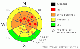
Danger Rose Tutorial
|
There's a level 3 or Considerable danger in the backcountry around Logan, and dangerous avalanche conditions exist on many upper and mid elevation slopes. I've included areas or pockets with a level 4 or HIGH danger, since in some areas, new snow and significant drifting last week overloaded and reactivated deeply buried weak layers. Dangerous and destructive triggered deep slab avalanches are likely in some places, especially in areas with a generally thin snowpack... Also, you are likely to trigger hidden and fresh wind slab avalanches, soft slabs, and loose sluffs in steep terrain. Cornices may be very sensitive and are likely to break further back than expected, and cornice falls could trigger very large avalanches on steep slopes below... Careful snowpack evaluation, cautious route finding, and conservative decision making will be essential this weekend in the backcountry... You'll find safer conditions in sheltered areas, at lower elevations, and on lower angled slopes... |
|
|
CURRENT CONDITIONS |

|
It's 15 degrees up at the 8400' Tony Grove Snotel this morning. There is now 94 inches of total snow on the ground containing 91% of normal water for the date. The station reported a couple more inches accumulation from showers yesterday evening and early this morning. The Campbell Scientific Logan Peak weather station at 9700' reports 5 degrees, and 10 mph northwest winds. Seems the front canyons, the Logan Peak Area, and the Wellsvilles picked up a bit more snow than the Central Bear River Range, but you'll find fine Utah Powder conditions throughout the zone... The problem is, you get tempted to play in steeper terrain because it's even more fun, overriding the fact that dangerous avalanche conditions certainly persist... |
|
|
RECENT ACTIVITY |

|
It was an active day yesterday across the mountains of northern Utah, with numerous human triggered avalanches reported from the backcountry.... We remote triggered a small cornice fall from about 30' to the windward while walking along the ridge, which triggered a very large hard slab, 4 to 6' deep and maybe 500' wide. This in turn caused another wider pocket a few hundred feet north to sympathetic 2' to 3' deep and 800' wide.... ENE.....EAST....ESE facing, at 9000' The avalanche ran on faceted December snow or depth hoar near the ground. The Avalanche was in White Rock Hollow, which we accessed from Middle Fork of Providence Canyon. While investigating the avalanche I triggered a bit of hang-fire, but was able to ski clear of the breaking slab.....
(go to our current conditions page for more details on local activity and reports of other recent avalanches in Utah) |
|
|
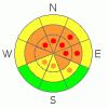
THREAT #1 |

|
| WHERE |
PROBABILITY |
SIZE |
TREND |
|
|
|
|
| |
|
|
Over the next
24 hours.
|
|
|
Depth hoar still plagues the basal layers of the snowpack in many areas, and it appears that in some areas this week's accumulation was enough to reactive the dragon. You might trigger a dangerous deep slab avalanche on a steep slope facing the northern half of the compass, particularly in areas with generally shallow and weak snow... It is possible that a wind slab, a cornice fall, or a persistent slab avalanche overrunning a slope with poor snow structure could cause a much larger and more dangerous deep slab avalanche. Avoid shallow or rocky terrain at upper and mid elevations, and keep in mind that you are most likely to trigger a very dangerous deep slab avalanche from an area where the slab layer is relatively thin.
Another persistent weak layer consisting of feathery surface hoar crystals and small sugary near surface facet grains was well preserved by light snow and little wind in early February, and became active with last week's spate of rider triggered avalanches. Unmanageable slab avalanches failing on buried persistent weak layers are likely to be 2 to 6 feet deep. Deep slab avalanches may be quite sensitive in some areas, and you might trigger one remotely, from a distance, or worse from below. |
|
|
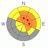
THREAT #2 |

|
| WHERE |
PROBABILITY |
SIZE |
TREND |
|
|
|
|
| |
|
|
Over the next
24 hours.
|
|
|
Strong southwest winds Wednesday built thick and stiff wind slabs in exposed terrain, and then a foot to a foot-and-a-half of powdery new snow fell and hid them nicely. You'll find stiff wind slabs under the powder on the lee sides of major ridge lines and in and around terrain features like sub-ridges, gullies, scoops, and cliff bands. Fresh wind slabs are developing as moderate northwest winds can easily find light, transportable snow. Overhanging ridge-top cornices were greatly enlarged by Wednesday's wind and may still be hair trigger sensitive or stubborn and tricky, and they are likely to break further back from the edge than you might expect. Cornice falls are likely to trigger potentially large slab avalanches on steep drifted slopes below... |
|
|
MOUNTAIN WEATHER |

|
It will be mostly cloudy today with a good chance for a couple inches of snow, moderate northwest winds, and temperatures in the mid twenties.... Looks like Sunday will be clear and sunny and much warmer. A ridge of high pressure will bring fair weather to the area Sunday and Monday, with the next Pacific storm expected on Tuesday, with a little snow possible. |
|
|
GENERAL ANNOUNCEMENTS |
Please consider a donation to your favorite non-profit –The Friends of the Utah Avalanche Center. The Utah Avalanche Center depends on contributions from users like you to support our work.....
Please send us your observations from the backcountry especially if you see or trigger an avalanche, but also even if you don't.. go to avalanche and snow observations. You can also call me directly at 435-757-7578 or leave us a message at our office, 801-524-5304.... And, you can always send us a simple email by clicking HERE
I will update this advisory by around 7:30 in the morning on Mondays, Wednesdays, Fridays, and Saturdays.....
This advisory is from the U.S.D.A. Forest Service, which is solely responsible for its content. This advisory describes general avalanche conditions and local variations always occur. |
|
|
This information does not apply to developed ski areas or highways where avalanche control is normally done. This advisory is from the U.S.D.A. Forest Service, which is solely responsible for its content. This advisory describes general avalanche conditions and local variations always occur. |
|
This advisory provided by the USDA Forest Service, in partnership with:
The Friends of the Utah Avalanche Center, Utah Division of State Parks and Recreation, Utah Division of Emergency Management, Salt Lake County, Salt Lake Unified Fire Authority and the friends of the La Sal Avalanche Center. See our Sponsors Page for a complete list. |
