AVALANCHE WARNING »
Dangerous avalanche conditions are occuring or are imminent.
Backcountry travel in avalanche terrain is not recommended.
|
 |
Notice: We've continued an avalanche warning for the Logan Forecast Zone. Strong winds and heavy snowfall overloaded preexisting weak layers. Natural avalanches are unlikely today, but human triggered avalanches remain likely on steep upper and mid elevation slopes. Careful snowpack evaluation, cautious route finding, and conservative decision making will be essential today in the backcountry... Avoid and stay out from under steep drifted slopes at upper and mid elevations. |
|
|
BOTTOM LINE
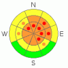
Danger by aspect and elevation on slopes approaching 35° or steeper.
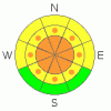
(click HERE for tomorrow's danger rating)
|
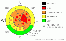
Danger Rose Tutorial
|
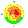
There's a level 4 or HIGH danger in the backcountry around Logan, and dangerous avalanche conditions exist on recently drifted upper and mid elevation slopes. Human triggered persistent slabs, hidden wind slabs, cornice falls, and new snow avalanches are all likely on steep slopes, and destructive deep slab avalanches are still possible, especially in areas with a generally thin snowpack... Careful snowpack evaluation, cautious route finding, and conservative decision making will be essential today in the backcountry... Avoid and stay out from under steep drifted slopes at upper and mid elevations. You'll find safer conditions in sheltered areas, at lower elevations, and on lower angled slopes... |
|
|
CURRENT CONDITIONS |

|
It's 10 degrees up at the 8400' Tony Grove Snotel this morning. There is now 97 inches of total snow on the ground containing 91% of normal water for the date. The station reported 12" of powder accumulation from late Wednesday and a few more inches yesterday evening, containing 1.6 inches of water in the last 48 hours. The Ben Lomond Snotel reports 18" with 1.3" of water in the last 24 hours, and most of that snow fell late last night.
The CSI Logan Peak weather station at 9700' reports a frosty 2 degrees this morning, and increasing northwest winds overnight, now averaging in the teens. Wednesday, the station recorded sustained south and southwest winds, with hourly average windspeeds approaching 40 mph and gusts near 70 mph... Extensive drifting occurred at upper elevations, but a foot or more of nice powder fell since on top of the stiff drifts, and the suspect wind slabs are now well hidden... |
|
|
RECENT ACTIVITY |

|
It was an active day yesterday in the mountains of northern Utah, with lots of natural and several human triggered avalanches reported from the backcountry.... Of particular note was a very large natural release in South Monitor Bowl on the Park City Ridgeline, which was at least 6 feet deep and around 1000 feet wide, running on basal layer depth hoar and exposing rocky ground... Several of the human triggered avalanches broke into old snow, and a couple were remote triggered from a distance....
Poor visibility prevented me from seeing much yesterday, but I did notice evidence of widespread natural sluffs and shallow soft slabs in the new snow up in Providence Canyon. Last week was quite active in the Bear River Range, with at least half-a-dozen very close calls, 3 or 4 partial burials, and numerous large sledder triggered and natural avalanches.
(go to our current conditions page for more details on local activity and reports of other recent avalanches in Utah) |
|
|
THREAT #1 |

|
| WHERE |
PROBABILITY |
SIZE |
TREND |
|
|
|
|
| |
|
|
Over the next
24 hours.
|
|
|
A layer consisting of feathery surface hoar crystals and small sugary near surface facet grains was well preserved by light snow and little wind beginning on February 8. This layer became active last week, with significant loading from heavy snow and wind drifting, and the persistent weakness caused several close calls locally, with at least half-a-dozen riders caught and carried and a few mostly buried. Today, heavy snow and strong winds from yesterday may well have added enough weight to the snowpack to reactivate this layer. Unmanageable slab avalanches failing on buried persistent weak layers are likely to be 2 to 4 feet deep. Persistent slab avalanches may be quite sensitive in some areas, and you might trigger one remotely, from a distance, or worse from below.
Depth hoar still plagues the basal layers of the snowpack in many areas. You might trigger a dangerous deep slab avalanche on a steep slope facing the northern half of the compass, particularly in areas with generally shallow and weak snow... It is possible that a wind slab, a cornice fall, or a persistent slab avalanche overrunning a slope with poor snow structure could cause a much larger and more dangerous deep slab avalanche. Avoid shallow or rocky terrain at upper and mid elevations, and keep in mind that you are most likely to trigger a very dangerous deep slab avalanche from an area where the slab layer is relatively thin. |
|
|
THREAT #2 |

|
| WHERE |
PROBABILITY |
SIZE |
TREND |
|
|
|
|
| |
|
|
Over the next
24 hours.
|
|
|
Strong southwest winds Wednesday built thick and stiff wind slabs in exposed terrain, and then around a foot of new snow fell and hid them nicely. You'll find stiff wind slabs under the powder on the lee sides of major ridge lines and in and around terrain features like sub-ridges, gullies, scoops, and cliff bands. Overhanging ridge-top cornices where greatly enlarged by Wednesday's wind and may still be hair trigger sensitive or stubborn and tricky, and they are likely to break further back from the edge than you might expect. Cornice falls are likely trigger slab avalanches on steep drifted slopes below... |
|
|
THREAT #3 |

|
| WHERE |
PROBABILITY |
SIZE |
TREND |
|
|
|
|
| |
|
|
Over the next
24 hours.
|
|
|
Loose sluffs and soft slabs may be more manageable than avalanches releasing into old snow, but you could easily be swept into terrain traps or trees below you. You'll want to avoid and stay out from under steep drifted slopes and slopes with significant accumulations of fresh snow. A new snow avalanche overrunning a slope with poor snow structure could cause the avalanche to step down into older snow and become larger and more dangerous. |
|
|
MOUNTAIN WEATHER |

|
Snow showers are likely to continue this morning, but expect little in the way of accumulation. It will be mostly cloudy, with 8500' high temperatures of around 17 degrees and ridgetop northwest winds around 15 mph... Clouds will thicken overnight and there's a chance for a little snow. It will be mostly cloudy tomorrow with a good chance for a couple inches of snow and temperatures in the mid twenties.... Looks like Sunday will be clear and sunny and much warmer. A ridge of high pressure will bring fair weather to the area Sunday and Monday, with the next Pacific storm expected on Tuesday afternoon.... |
|
|
GENERAL ANNOUNCEMENTS |
Please consider a donation to your favorite non-profit –The Friends of the Utah Avalanche Center. The Utah Avalanche Center depends on contributions from users like you to support our work.....
Please send us your observations from the backcountry especially if you see or trigger an avalanche, but also even if you don't.. go to avalanche and snow observations. You can also call me directly at 435-757-7578 or leave us a message at our office, 801-524-5304.... And, you can always send us a simple email by clicking HERE
I will update this advisory by around 7:30 in the morning on Mondays, Wednesdays, Fridays, and Saturdays.....
This advisory is from the U.S.D.A. Forest Service, which is solely responsible for its content. This advisory describes general avalanche conditions and local variations always occur. |
|
|
This information does not apply to developed ski areas or highways where avalanche control is normally done. This advisory is from the U.S.D.A. Forest Service, which is solely responsible for its content. This advisory describes general avalanche conditions and local variations always occur. |
|
This advisory provided by the USDA Forest Service, in partnership with:
The Friends of the Utah Avalanche Center, Utah Division of State Parks and Recreation, Utah Division of Emergency Management, Salt Lake County, Salt Lake Unified Fire Authority and the friends of the La Sal Avalanche Center. See our Sponsors Page for a complete list. |
