AVALANCHE WARNING »
Dangerous avalanche conditions are occuring or are imminent.
Backcountry travel in avalanche terrain is not recommended.
|
 |
Notice: We've continued an avalanche warning for the Logan Forecast Zone and all the mountains of northern and central Utah.. Strong winds and heavy snowfall overloaded preexisting weak layers yesterday, and more significant snowfall is expected today. Avoid and stay out from under steep drifted slopes and obvious or historic avalanche paths.... |
|
|
BOTTOM LINE
Danger by aspect and elevation on slopes approaching 35° or steeper.
(click HERE for tomorrow's danger rating)
|
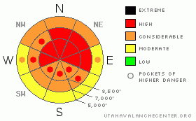
Danger Rose Tutorial
|
There's a level 4 or HIGH danger in the backcountry around Logan, and dangerous avalanche conditions exist on many slopes. Natural avalanche are possible today, especially during periods with heavy snowfall. Human triggered wind slabs, cornice falls, storm snow, and persistent slab avalanches are all likely on steep slopes, and destructive deep slab avalanches are still possible, especially in areas with a generally thin snowpack... Continuing snowfall and drifting today will keep avalanche conditions dangerous on steep slopes in the backcountry. We recommend that you do not travel in avalanche terrain today. You should avoid and stay out from under all steep slopes, especially obvious or historic avalanche paths... |
|
|
CURRENT CONDITIONS |

|
It's a frigid 3 degrees up at the 8400' Tony Grove Snotel this morning. There is now 96 inches of total snow on the ground containing 90% of normal water for the date. The station reported 12" of accumulation from late yesterday, containing an inch of water. Beaver Mountain is reporting 14 inches of new snow this morning, which makes yesterday's storm one of the most productive of the season. The CSI Logan Peak weather station at 9700' reports 4 degrees this morning, and southwest winds averaging a bit less than 20 mph.. Yesterday, the station recorded sustained south and southwest winds, with hourly average windspeeds approaching 40 mph in the afternoon... Another good shot of snow is likely today and tonight, with 11 to 19 inches of additional snow possible in the mountains by tomorrow morning.... It will be a good day to ride the lifts or play in lower angled terrain, due to dangerous avalanche conditions on steep slopes in the backcountry. |
|
|
RECENT ACTIVITY |

|
There were a few eye opening natural avalanches yesterday in the Utah Mountains, and a good sized triggered avalanche in the Provo Mountains. Poor visibility prevented me from seeing much, but substantial drifting was obvious, and drifting was also occurring at all elevations..
Locally: last week was quite active in the Bear River Range, with at least half-a-dozen very close calls, 3 or 4 partial burials, and numerous large sledder triggered and natural avalanches. Luckily, and thanks to technology and quick acting partners, everybody is okay, with injuries only involving some machine damage. Most of last week's avalanches can be blamed on a buried persistent weak layer from early February made up of preserved surface hoar and/or small sugary near surface facets.... This layer is again suspect today.
(go to our current conditions page for more details on local activity and reports of other recent avalanches in Utah) |
|
|
THREAT #1 |

|
| WHERE |
PROBABILITY |
SIZE |
TREND |
|
|
|
|
| |
|
|
Over the next
24 hours.
|
|
|
A layer consisting of feathery surface hoar crystals and small sugary near surface facet grains was well preserved by light snow and little wind beginning on February 8. This layer became active last week, with significant loading from heavy snow and wind drifting, and the persistent weakness caused several close calls locally, with at least half-a-dozen riders caught and carried and a few mostly buried. Today, heavy snow and strong winds from yesterday may well have added enough weight to the snowpack to reactivate this layer. Unmanageable slab avalanches failing on buried persistent weak layers are likely to be 2 to 4 feet deep. Persistent slab avalanches may be quite sensitive in some areas, and you might trigger one remotely, from a distance, or worse from below.
Large faceted grains or depth hoar plagues the basal layers of the snowpack in many areas. You might trigger a dangerous deep slab avalanche on a steep slope facing the northern half of the compass, particularly in areas with generally shallow and weak snow... It is possible that a wind slab, a cornice fall, or a persistent slab avalanche overrunning a slope with poor snow structure could cause a much larger and more dangerous deep slab avalanche. Avoid shallow or rocky terrain at upper and mid elevations, and keep in mind that you are most likely to trigger a very dangerous deep slab avalanche from an area where the slab layer is relatively thin. |
|
|
THREAT #2 |

|
| WHERE |
PROBABILITY |
SIZE |
TREND |
|
|
|
|
| |
|
|
Over the next
24 hours.
|
|
|
Strong southwest winds yesterday built thick and stiff wind slabs in exposed terrain, and then a foot of new snow fell and hid them nicely. You'll find fresh wind slabs under the powder on the lee sides of major ridge lines and in and around terrain features like sub-ridges, gullies, scoops, and cliff bands. Overhanging ridge-top cornices where greatly enlarged by yesterday's wind and may be hair trigger sensitive or stubborn and tricky, and today they are likely to break further back from the edge than you might expect. Cornice falls are likely trigger slab avalanches on steep drifted slopes below... |
|
|
THREAT #3 |

|
| WHERE |
PROBABILITY |
SIZE |
TREND |
|
|
|
|
| |
|
|
Over the next
24 hours.
|
|
|
Avalanches involving just new snow from yesterday and/or today could be pretty big... Loose sluffs and soft slabs may be more manageable than avalanches releasing into old snow, but you could easily be swept into terrain traps or trees below you. You'll want to avoid and stay out from under steep drifted slopes and slopes with significant accumulations of new snow. A new snow avalanche overrunning a slope with poor snow structure could cause the avalanche to step down into older snow and become larger and more dangerous. |
|
|
MOUNTAIN WEATHER |

|
A Pacific storm will continue to impact our area, with substantial additional snowfall likely today and tonight. Expect moderate west winds today, with 8500' high temperatures in the mid teens, and another foot of snow possible. Moderate west winds will be plenty strong enough to cause significant drifting of the new and falling snow today. Mountain temperatures will drop well into the single digits overnight, winds will increase a bit and come out of the northwest, and 4 to 8 inches of additional accumulation is expected... The weather will remain unsettled into the weekend, with a bit of a break and a little sunshine expected for Sunday... |
|
|
GENERAL ANNOUNCEMENTS |
Please consider a donation to your favorite non-profit –The Friends of the Utah Avalanche Center. The Utah Avalanche Center depends on contributions from users like you to support our work.....
Please send us your observations from the backcountry especially if you see or trigger an avalanche, but also even if you don't.. go to avalanche and snow observations. You can also call me directly at 435-757-7578 or leave us a message at our office, 801-524-5304.... And, you can always send us a simple email by clicking HERE
I will update this advisory by around 7:30 in the morning on Mondays, Wednesdays, Fridays, and Saturdays.....
This advisory is from the U.S.D.A. Forest Service, which is solely responsible for its content. This advisory describes general avalanche conditions and local variations always occur. |
|
|
This information does not apply to developed ski areas or highways where avalanche control is normally done. This advisory is from the U.S.D.A. Forest Service, which is solely responsible for its content. This advisory describes general avalanche conditions and local variations always occur. |
|
This advisory provided by the USDA Forest Service, in partnership with:
The Friends of the Utah Avalanche Center, Utah Division of State Parks and Recreation, Utah Division of Emergency Management, Salt Lake County, Salt Lake Unified Fire Authority and the friends of the La Sal Avalanche Center. See our Sponsors Page for a complete list. |
