AVALANCHE WARNING »
Dangerous avalanche conditions are occuring or are imminent.
Backcountry travel in avalanche terrain is not recommended.
|
 |
Notice: We've issued an avalanche warning for the Logan Forecast Zone and all the mountains of northern and central Utah, effective from noon today through Thursday. Strong winds and heavy snowfall today and tonight will increase the avalanche danger in the backcountry… first expect a HIGH danger in the mountains north of I-80 as of noon today. The danger will rise to HIGH in the mountains south of I-80, the western Uintas, and the central Utah mountains tonight through Thursday. Dangerous backcountry avalanche conditions are developing and will remain elevated through Thursday. Avoid and stay out from under steep drifted slopes and obvious or historic avalanche paths.... |
|
|
BOTTOM LINE
Danger by aspect and elevation on slopes approaching 35° or steeper.
(click HERE for tomorrow's danger rating)
|
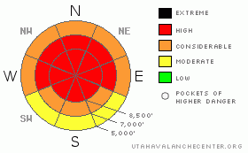
Danger Rose Tutorial
|
This morning, there's a level 3 or Considerable danger in the backcountry around Logan, and dangerous avalanche conditions exist in drifted terrain at upper and mid elevations. Human triggered wind slabs, cornice falls, and persistent slab avalanches are likely at upper and mid elevations, and destructive deep slab avalanches are still possible, especially in areas with a generally thin snowpack... Heavy snowfall and strong southwest and westerly winds will cause an increasing danger throughout the day, and the danger will rise to level 4 or HIGH this afternoon... Natural avalanches will become likely around the time of frontal passage, especially during periods with very heavy snowfall... Careful snowpack evaluation, cautious route finding, and conservative decision making will be essential in the backcountry, and you should avoid and stay out from under steep drifted slopes and obvious or historic avalanche paths during today's storm. |
|
|
CURRENT CONDITIONS |

|
It's 19 degrees up at the 8400' Tony Grove Snotel this morning. There is now 86 inches of total snow on the ground containing 87% of normal water for the date. The station reported 5" of accumulation from yesterday and overnight, containing 4/10ths of an inch of water. The CSI Logan Peak weather station at 9700' reports 13 degrees this morning, and south winds averaging over 30 mph and gusting into the mid 40s. A significant Pacific storm will impact the Logan Area today, with strong winds and heavy snow. This will create a rapid increase in avalanche danger, and conditions are already dangerous on many steep slopes this morning in the backcountry. |
|
|
RECENT ACTIVITY |

|
There were several triggered avalanches yesterday in the Utah Mountains, and some remote triggered (or triggered from a distance,) by backcountry skiers in the Central Wasatch Range and the ridge above Park City.. Remote triggered avalanches indicate the presence of buried persistent weak layers....
Locally: last week was quite active in the Bear River Range, with at least half-a-dozen very close calls, 3 or 4 partial burials, and numerous large sledder triggered and natural avalanches. Luckily, and thanks to technology and quick acting partners, everybody is okay, with injuries only involving some machine damage. Most of last week's avalanches can be blamed on a buried persistent weak layer from early February made up of preserved surface hoar and/or small sugary near surface facets....
(go to our current conditions page for more details on local activity and reports of other recent avalanches in Utah) |
|
|
THREAT #1 |

|
| WHERE |
PROBABILITY |
SIZE |
TREND |

|
|
|
|
| |
|
|
Over the next
24 hours.
|
|
|
Winds picked up substantially late last night from the south, and southwest winds are forecast to intensify further today as a well defined cold front surges through the zone. With yesterday's fresh powder readily available for transport, significant drifting already occurred early this morning, and will continue throughout the day today. You'll find fresh wind slabs on the lee sides of major ridge lines and in and around terrain features like sub-ridges, gullies, scoops, and cliff bands. Overhanging ridge-top cornices may be hair trigger sensitive or stubborn and tricky, and today they are likely to break further back than you expect. Cornice falls are likely trigger slab avalanches on steep drifted slopes below... |
|
|
THREAT #2 |

|
| WHERE |
PROBABILITY |
SIZE |
TREND |
|
|
|
|
| |
|
|
Over the next
24 hours.
|
|
|
A layer consisting of feathery surface hoar crystals and small sugary near surface facet grains was well preserved by light snow and little wind beginning on February 8. This layer became active last week, with significant loading from heavy snow and wind drifting, and the persistent weakness caused several close calls locally, with at least half-a-dozen riders caught and carried and a few mostly buried. Today, heavy snow and strong winds will probably add enough weight to the snowpack to reactivate this layer. Unmanageable slab avalanches failing on buried persistent weak layers are likely to be 1.5 to 3 feet deep. Today, persistent slab avalanches may be quite sensitive in some areas, and you might trigger one remotely, from a distance, or worse from below.
Large faceted grains or depth hoar plagues the basal layers of the snowpack in many areas. You might trigger a dangerous deep slab avalanche on a steep slope facing the northern half of the compass, particularly in areas with generally shallow and weak snow... It is possible that a wind slab, a cornice fall, or a persistent slab avalanche overrunning a slope with poor snow structure could cause a much larger and more dangerous deep slab avalanche. Avoid shallow or rocky terrain at upper and mid elevations, and keep in mind that you are most likely to trigger a very dangerous deep slab avalanche from an area where the slab layer is relatively thin. |
|
|
THREAT #3 |

|
| WHERE |
PROBABILITY |
SIZE |
TREND |

|
|
|
|
| |
|
|
Over the next
24 hours.
|
|
|
Today's storm, with heavy snowfall and strong winds, will cause an increasing avalanche danger. The danger is likely to rise to High this afternoon, and natural avalanches will be probable during periods with very heavy snowfall and drifting around the time of frontal passage, which should be mid to late afternoon in the Logan Zone.... In addition to likely storm snow and wind slab avalanches as a direct result of the storm, the weight of the new and drifted snow will also cause and increasing danger of deeper avalanches failing on persistent weak layers or basal depth hoar....
You'll want to avoid and stay out from under steep drifted slopes. |
|
|
MOUNTAIN WEATHER |

|
A Pacific storm will impact our area today through tomorrow. Expect intensifying windy conditions today, with a south-southwest wind this morning, becoming more westerly today, and from the northwest tonight after frontal passage this afternoon. Ridgetop winds should sustain hourly averages above 30 mph today and tonight, with gusts in the mid fifties forecast.. 8500' high temperatures of around 27 degrees are expected, and snowfall will be heavy at times, with 7 to 11 inches of accumulation forecast during the day today. Another foot or two will likely accumulate in the mountains of Far Northern Utah tonight, tomorrow and tomorrow night.... The weather will remain stormy and unsettled through the week, with a bit of a break and a little Sunshine late in the coming weekend... |
|
|
GENERAL ANNOUNCEMENTS |
Please consider a donation to your favorite non-profit –The Friends of the Utah Avalanche Center. The Utah Avalanche Center depends on contributions from users like you to support our work.....
Please send us your observations from the backcountry especially if you see or trigger an avalanche, but also even if you don't.. go to avalanche and snow observations. You can also call me directly at 435-757-7578 or leave us a message at our office, 801-524-5304.... And, you can always send us a simple email by clicking HERE
I will update this advisory by around 7:30 in the morning on Mondays, Wednesdays, Fridays, and Saturdays.....
This advisory is from the U.S.D.A. Forest Service, which is solely responsible for its content. This advisory describes general avalanche conditions and local variations always occur. |
|
|
This information does not apply to developed ski areas or highways where avalanche control is normally done. This advisory is from the U.S.D.A. Forest Service, which is solely responsible for its content. This advisory describes general avalanche conditions and local variations always occur. |
|
This advisory provided by the USDA Forest Service, in partnership with:
The Friends of the Utah Avalanche Center, Utah Division of State Parks and Recreation, Utah Division of Emergency Management, Salt Lake County, Salt Lake Unified Fire Authority and the friends of the La Sal Avalanche Center. See our Sponsors Page for a complete list. |
