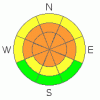
BOTTOM LINE
Danger by aspect and elevation on slopes approaching 35° or steeper.
(click HERE for tomorrow's danger rating)
|

Danger Rose Tutorial
|
There's a level 3 or Considerable danger in the backcountry around Logan, and dangerous avalanche conditions exist in drifted terrain at upper and mid elevations. There are also pockets with a level 4 or High danger on some steep slopes at upper elevations exposed to drifting by overnight southeast and today's south winds. Human triggered wind slabs, cornice falls, and persistent slab avalanches remain likely at upper and mid elevations, and destructive deep slab avalanches are still possible, especially in areas with a generally thin snowpack... Careful snowpack evaluation, cautious route finding, and conservative decision making will be essential in the backcountry today. Continue to avoid and stay out from under steep drifted slopes. You'll find safer conditions on sheltered slopes and in lower angle terrain. I'm talking about slopes less than about 30 degrees without steeper terrain above.... |
|
|
CURRENT CONDITIONS |

|
It's 15 degrees up at the 8400' Tony Grove Snotel this morning. There is now 84 inches of total snow on the ground containing 87% of normal water for the date. The station reported 8" of accumulation from Saturday and Saturday night and another inch from yesterday evening.. The CSI Logan Peak weather station at 9700' reports 18 degrees this morning, and southeast winds averaging around 33 mph and gusting into the 50s. Conditions improved on lower angled slopes and at lower elevations, with several inches of creamy fresh snow from over the weekend capping a wide variety of crusts.... |
|
|
RECENT ACTIVITY |

|
There were numerous triggered avalanches over the weekend in the Utah Mountains, with avalanches triggered by explosives, sledders, and skiers.. Yesterday, several avalanches in the Wasatch Range were remote triggered (or triggered from a distance,) which indicates the presence of buried persistent weak layers....
Locally: last week was quite active in the Bear River Range, with at least a handful of very close calls, and numerous large sledder triggered and natural avalanches. Luckily, and thanks to technology and quick acting partners, everybody is okay, with injuries only involving some machine damage. Most of last week's avalanches can be blamed on a buried persistent weak layer from early February made up of preserved surface hoar and/or small sugary near surface facets....
(go to our current conditions page for more details on local activity and reports of other recent avalanches in Utah) |
|
|
THREAT #1 |

|
| WHERE |
PROBABILITY |
SIZE |
TREND |

|
|
|
|
| |
|
|
Over the next
24 hours.
|
|
|
Winds picked up substantially late last night from the southeast, and sustained hourly average windspeeds in excess of 30 mph for several hours.... With Saturday night's fresh powder readily available for transport, significant drifting occurred overnight and continues this morning.. Wind slabs and cornices are building in different areas and in a different way then with the strong westerlies last week and Saturday... Exposed west, northwest, and north facing slopes at upper elevations are likely to have pretty deep fresh and stiff wind deposits and may only now become active, since they missed out on last week's loading...
Overhanging ridge-top cornices may be very sensitive or stubborn and tricky, and today they are likely to break further back than you expect. Cornice falls could trigger wind slab avalanches failing on persistent weak layers on steep drifted slopes below... |
|
|
THREAT #2 |

|
| WHERE |
PROBABILITY |
SIZE |
TREND |
|
|
|
|
| |
|
|
Over the next
24 hours.
|
|
|
Wind slabs and heavy storm snow piled up on top of shallowly buried suspect weak snow that was on the surface in early February. Stiff slabs formed on the lee sides of major ridge lines and in and around terrain features like sub-ridges, gullies, scoops, and cliff bands. A layer consisting of feathery surface hoar crystals and small sugary near surface facet grains was well preserved by light snow and little wind beginning on February 8. This layer became active last week, with significant loading from heavy snow and wind drifting. Unmanageable slab avalanches failing on buried persistent weak layers are likely to be 1.5 to 3+ feet deep. Today, persistent slab avalanches may still be quite sensitive in some areas, and you might trigger one remotely, from a distance, or worse from below. Avoid slopes with buried persistent weak layers steeper than about 30 degrees.... Avalanches failing on buried surface hoar tend to fool people by releasing on lower angled slopes than expected.... |
|
|
THREAT #3 |

|
| WHERE |
PROBABILITY |
SIZE |
TREND |
|
|
|
|
| |
|
|
Over the next
24
hours.
|
|
|
It is possible that a wind slab, a cornice fall, or a persistent slab avalanche overrunning a slope with poor snow structure could cause a much larger and more dangerous deep slab avalanche... Large faceted grains or depth hoar plagues the basal layers of the snowpack in many areas. You might trigger a dangerous deep slab avalanche on a steep slope facing the northern half of the compass, particularly in areas with generally shallow and weak snow... Avoid shallow or rocky terrain at upper and mid elevations, and keep in mind that you are most likely to trigger a very dangerous deep slab avalanche from an area where the slab layer is relatively thin. It is possible the weight of a single person could be enough to trigger a large avalanche, and you might trigger one remotely, from a distance or below. |
|
|
MOUNTAIN WEATHER |

|
A Pacific storm will impact our area today and tomorrow. Expect windy conditions today, with a south-southwest wind and 8500' high temperatures around 27 degrees forecast. Snow showers are likely this afternoon, but not much in the way of accumulation is likely until tonight.... Mountain temperatures will drop into the teens tonight, winds will gradually intensify and swing around from the west, and snow is likely tonight through most of tomorrow, with 6 to 9 inches of accumulation by tomorrow night the current forecast... Another storm will bring more snow beginning Wednesday afternoon and lasting through midday Thursday.. |
|
|
GENERAL ANNOUNCEMENTS |
Please consider a donation to your favorite non-profit –The Friends of the Utah Avalanche Center. The Utah Avalanche Center depends on contributions from users like you to support our work.....
Please send us your observations from the backcountry especially if you see or trigger an avalanche, but also even if you don't.. go to avalanche and snow observations. You can also call me directly at 435-757-7578 or leave us a message at our office, 801-524-5304.... And, you can always send us a simple email by clicking HERE
I will update this advisory by around 7:30 in the morning on Mondays, Wednesdays, Fridays, and Saturdays.....
This advisory is from the U.S.D.A. Forest Service, which is solely responsible for its content. This advisory describes general avalanche conditions and local variations always occur. |
|
|
This information does not apply to developed ski areas or highways where avalanche control is normally done. This advisory is from the U.S.D.A. Forest Service, which is solely responsible for its content. This advisory describes general avalanche conditions and local variations always occur. |
|
This advisory provided by the USDA Forest Service, in partnership with:
The Friends of the Utah Avalanche Center, Utah Division of State Parks and Recreation, Utah Division of Emergency Management, Salt Lake County, Salt Lake Unified Fire Authority and the friends of the La Sal Avalanche Center. See our Sponsors Page for a complete list. |
