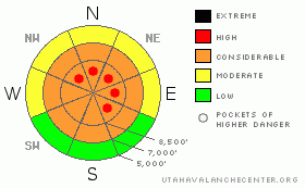
BOTTOM LINE
Danger by aspect and elevation on slopes approaching 35° or steeper.
(click HERE for tomorrow's danger rating)
|
Danger Rose Tutorial
|
There's a level 3 or Considerable danger in the backcountry around Logan, and dangerous avalanche conditions exist in drifted terrain at upper and mid elevations. There are also pockets with a level 4 or High danger on steep lee-side slopes at upper elevations, where large cornices and deep stiff wind slabs developed earlier in the week and again yesterday. Human triggered cornice falls, wind slabs,and/or persistent slab avalanches remain likely at upper and mid elevations, and destructive deep slab avalanches are still possible, especially in areas with a generally thin snowpack... Careful snowpack evaluation, cautious route finding, and conservative decision making will be essential in the backcountry today. Continue to avoid and stay out from under steep drifted slopes. You'll find safer conditions on sheltered slopes and in lower angle terrain, on slopes less than about 30 degrees... |
|
|
CURRENT CONDITIONS |

|
It's a cold 9 degrees up at the 8400' Tony Grove Snotel this morning. There is now 84 inches of total snow on the ground containing 87% of normal water for the date. The station reports 8" of accumulation in the last 24 hrs, containing 8/10thsof an inch of water... Beaver Mountain reports 6 inches of new snow mostly from yesterday..The CSI Logan Peak weather station at 9700' reports 1 degree this morning, and west winds averaging in the single digits. The Hwy 89 Logan Summit weather station is reporting northwest winds averaging in the teens and twenties early this morning... It will be a good day to ride the lifts or boondock in the meadows far away from the big hills..... |
|
|
RECENT ACTIVITY |

|
There were numerous very scary large triggered avalanches over the weekend in the Utah Mountains, with avalanches triggered by explosives, sledders, and skiers.. Tragically, a snowboarder was killed by an avalanche in the Wasatch Range near Park City on Thursday.. Closer to the Logan Zone; a rider was caught, carried, mostly buried, and badly injured yesterday morning by an avalanche he triggered on Whiskey Hill in the Monte Cristo Area...
Locally; riders remote triggered a 2' deep and 175' wide avalanche on Competition Hill in Crescent Lake Canyon around midday on Friday. The avalanche failed on preserved frost crystals or surface hoar. Riders intentionally triggered a similar avalanche in the north fork of White Pine Canyon with a slope cut on Friday afternoon.Three other very lucky brushes with large avalanches were reported to the Utah Avalanche Center this week from the backcountry around Logan. A rider triggered and was caught by a 3 foot+ deep slab Monday morning in the Beaver Creek Area just north of the Idaho State Line. He escaped by grabbing a small tree as he was swept downhill... A rider triggered and was caught and carried by a 3' deep and 200' wide avalanche Wednesday in Crescent Lake Canyon out of Franklin Basin. Luckily, he was able to stay on his sled and ride out of the flowing debris... Also on Wednesday a rider triggered a broad avalanche north of Tony Grove Lake and deployed his air bag... He was swept off his sled and mostly buried on his side, with only the very top of his helmet and some of his air bag exposed.
(go to our current conditions page for more details on local activity and reports of other recent avalanches in Utah) |
|
|
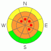
THREAT #1 |

|
| WHERE |
PROBABILITY |
SIZE |
TREND |
|
|
|
|
| |
|
|
Over the next
24 hours.
|
|
|
Wind slabs and heavy storm snow piled up on top of shallowly buried suspect weak snow that was on the surface in early February. Stiff slabs formed on the lee sides of major ridge lines and in and around terrain features like sub-ridges, gullies, scoops, and cliff bands. A layer consisting of feathery surface hoar crystals and widespread small sugary near surface facet grains was well preserved by light snow with little wind beginning on February 8. This layer has become active this week, with significant loading from heavy snow and wind drifting. Wind slab and soft slab avalanches failing on buried persistent weak layers are likely to be 1.5 to 3+ feet deep, and will fall into the unmanageable category..... Today, persistent slab avalanches may still be quite sensitive, and you might trigger one remotely, from a distance, or worse from below. Pay attention to red flags like whumpfing and shooting cracks, and avoid slopes steeper than about 30 degrees... Avalanches failing on buried surface hoar tend to fool people by releasing on lower angled slopes than expected.... |
|
|
THREAT #2 |

|
| WHERE |
PROBABILITY |
SIZE |
TREND |
|
|
|
|
| |
|
|
Over the next
24 hours.
|
|
|
The strong and sustained westerly winds earlier in the week and yesterday built huge new cornices along ridgelines. Overhanging ridge-top cornices may be very sensitive or stubborn and tricky, and today they are likely to break further back than you expect. Cornice falls could trigger wind slab avalanches failing on persistent weak layers on steep drifted slopes below... |
|
|
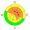
THREAT #3 |

|
| WHERE |
PROBABILITY |
SIZE |
TREND |

|
|
|
|
| |
|
|
Over the next
24
hours.
|
|
|
It is possible that a persistent slab avalanche, or a cornice fall overrunning a slope with poor snow structure could cause a much larger and more dangerous deep slab avalanche... You also could trigger a dangerous hard slab avalanche on a steep slope facing the northern half of the compass, particularly in areas with shallow and weak snow... Avoid shallow or rocky terrain at upper and mid elevations, and keep in mind that you are most likely to trigger a very dangerous hard slab avalanche from an area where the slab layer is relatively thin. It is possible the weight of a single person could be enough to trigger a large avalanche, and you might trigger one remotely, from a distance or below. |
|
|
MOUNTAIN WEATHER |

|
Cold temperatures and way sub-zero wind chills will make for a chilly day today in the mountains. Snow showers are likely this morning, and the sun will come out in the afternoon as west winds gradually decrease . 8500' foot temperatures may climb to around 20 degrees today. A short lived ridge of high pressure will move over the area today and be pushed off to the east tomorrow by a developing storm in the northwest... This will bring an increase in southerly winds, increasing clouds, and snow showers tomorrow...Snow is likely tomorrow night, with several inches of accumulation probable.... Another storm will bring more snow beginning around Wednesday night and lasting through Thursday... |
|
|
GENERAL ANNOUNCEMENTS |
Please consider a donation to your favorite non-profit –The Friends of the Utah Avalanche Center. The Utah Avalanche Center depends on contributions from users like you to support our work.....
Please send us your observations from the backcountry especially if you see or trigger an avalanche, but also even if you don't.. go to avalanche and snow observations. You can also call me directly at 435-757-7578 or leave us a message at our office, 801-524-5304.... And, you can always send us a simple email by clicking HERE
I will update this advisory by around 7:30 in the morning on Mondays, Wednesdays, Fridays, and Saturdays.....
This advisory is from the U.S.D.A. Forest Service, which is solely responsible for its content. This advisory describes general avalanche conditions and local variations always occur. |
|
|
This information does not apply to developed ski areas or highways where avalanche control is normally done. This advisory is from the U.S.D.A. Forest Service, which is solely responsible for its content. This advisory describes general avalanche conditions and local variations always occur. |
|
This advisory provided by the USDA Forest Service, in partnership with:
The Friends of the Utah Avalanche Center, Utah Division of State Parks and Recreation, Utah Division of Emergency Management, Salt Lake County, Salt Lake Unified Fire Authority and the friends of the La Sal Avalanche Center. See our Sponsors Page for a complete list. |
