AVALANCHE WARNING »
Dangerous avalanche conditions are occuring or are imminent.
Backcountry travel in avalanche terrain is not recommended.
|
 |
Notice: An avalanche warning continues for the mountains in the Logan Area. Tricky and dangerous avalanche conditions will continue today on many slopes. People without expert level avalanche skills should avoid slopes approaching 35 degrees or steeper and stay out from underneath steep slopes. |
|
|
BOTTOM LINE
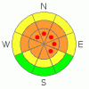
Danger by aspect and elevation on slopes approaching 35° or steeper.
(click HERE for tomorrow's danger rating)
|
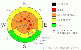
Danger Rose Tutorial
|
There's a level 3 or Considerable danger in the backcountry around Logan, and dangerous avalanche conditions exist in drifted terrain at upper and mid elevations. There are also a few pockets with a level 4 or High danger on steep lee-side slopes at upper elevations where large cornices and very deep wind slabs developed in the first half of the week. Rapid warming today will cause an increasing danger, and some natural avalanches and cornice falls are possible. Human triggered persistent slab avalanches are likely at upper and mid elevations, and destructive deep slab avalanches are possible, especially in areas with a generally thin snowpack... Careful snowpack evaluation, cautious route finding, and conservative decision making will be essential in the backcountry today. Continue to avoid and stay out from under steep drifted slopes and obvious or historic avalanche paths. |
|
|
CURRENT CONDITIONS |

|
It's13 degrees up at the 8400' Tony Grove Snotel this morning. There is now 80 inches of total snow on the ground containing 86% of normal water for the date. The CSI Logan Peak weather station at 9700' reports 6 degrees this morning, and the wind sensor is rimed. The Hwy 89 Logan Summit weather station reports overnight winds averaging 10 to 20 mph |
|
|
RECENT ACTIVITY |

|
Three very lucky brushes with large avalanches were reported to the Utah Avalanche Center this week in the backcountry around Logan. A rider triggered and was caught by a 3 foot+ deep slab Monday morning in the Beaver Creek Area just north of the Idaho State Line. He quickly grabbed a small aspen tree and watched as the 60' wide hard slab swept his sled several hundred feet through the trees below inflicting a fair amount of damage to the machine. A rider triggered and was caught and carried by a 3' deep and 200' wide avalanche Wednesday in Crescent lake Canyon out of Franklin Basin. Luckily, he was able to stay on his sled and ride out of the flowing debris before it ran through some large trees, leaving snow plastered over 12 feet up the thick trunks... Also on Wednesday a rider triggered a broad avalanche north of Tony Grove Lake and deployed his air bag... He was swept off his sled and mostly buried on his side, with only the very top of his helmet and some of his air bag exposed. Amazingly and thankfully, no injuries were reported from any of the incidents, any one of which could have easily been fatal....
(go to our current conditions page for more details on local activity and reports of other recent avalanches in Utah) |
|
|
THREAT #1 |

|
| WHERE |
PROBABILITY |
SIZE |
TREND |
|
|
|
|
| |
|
|
Over the next
24 hours.
|
|
|
Wind slabs and storm snow piled up on top of shallowly buried suspect weak snow that was on the surface in early February. Slabs formed on the lee sides of major ridge lines and in and around terrain features like sub-ridges, gullies, scoops, and cliff bands. A couple layers of feathery surface hoar crystals and widespread small sugary near surface facet grains were well preserved by the light snowfalls beginning on February 8. These have become active with recent significant loading. Soft slab and stiffer wind slab avalanches failing on buried persistent weak layers are likely to be 1.5 to 3 feet deep, and will fall into the unmanageable category..... Today, persistent slab avalanches may still be quite sensitive, and you might trigger one remotely, from a distance, or below. Pay attention to red flags like whumpfing and shooting cracks, and avoid slopes steeper than about 30 degrees... Avalanches failing on buried surface hoar tend to fool people by releasing on lower angled slopes than expected.... |
|
|
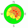
THREAT #2 |

|
| WHERE |
PROBABILITY |
SIZE |
TREND |
|
|
|
|
| |
|
|
Over the next
24 hours.
|
|
|
The strong and sustained westerly winds earlier in the week built huge new cornices along ridgelines and above terrain features in exposed terrain.. Overhanging ridge-top cornices may be very sensitive or stubborn and tricky, and today they are likely to break further back than you expect. Cornice falls could trigger persistent slab avalanches on steep drifted slopes below... |
|
|
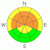
THREAT #3 |

|
| WHERE |
PROBABILITY |
SIZE |
TREND |
|
|
|
|
| |
|
|
Over the next
24
hours.
|
|
|
It is possible that a persistent slab avalanche, or a cornice fall overrunning a slope with poor snow structure could cause a much larger and more dangerous deep slab avalanche... You also could trigger a dangerous hard slab avalanche on a steep slope facing the northern half of the compass, particularly in areas with shallow and weak snow... Avoid shallow or rocky terrain at upper and mid elevations, and keep in mind that you are most likely to trigger a very dangerous hard slab avalanche from an area where the slab layer is relatively thin. It is possible the weight of a single person could be enough to trigger a large avalanche, and you might trigger one remotely, from a distance or below. |
|
|
MOUNTAIN WEATHER |

|
Expect mild temperatures and mostly sunny skies in the mountains today, with 8500' high temperatures approaching 30 degrees and light to moderate west winds. The next energetic pacific storm will bring more snow and strong westerly winds to the zone for the coming weekend, with another foot or so of accumulation possible. Unsettled weather will continue through next week, with a series of storms... It is possible that a storm organizing over western Canada could bring substantial snowfall to our area early in the week.... |
|
|
GENERAL ANNOUNCEMENTS |
Please consider a donation to your favorite non-profit –The Friends of the Utah Avalanche Center. The Utah Avalanche Center depends on contributions from users like you to support our work.....
Please send us your observations from the backcountry especially if you see or trigger an avalanche, but also even if you don't.. go to avalanche and snow observations. You can also call me directly at 435-757-7578 or leave us a message at our office, 801-524-5304.... And, you can always send us a simple email by clicking HERE
I will update this advisory by around 7:30 in the morning on Mondays, Wednesdays, Fridays, and Saturdays.....
This advisory is from the U.S.D.A. Forest Service, which is solely responsible for its content. This advisory describes general avalanche conditions and local variations always occur. |
|
|
This information does not apply to developed ski areas or highways where avalanche control is normally done. This advisory is from the U.S.D.A. Forest Service, which is solely responsible for its content. This advisory describes general avalanche conditions and local variations always occur. |
|
This advisory provided by the USDA Forest Service, in partnership with:
The Friends of the Utah Avalanche Center, Utah Division of State Parks and Recreation, Utah Division of Emergency Management, Salt Lake County, Salt Lake Unified Fire Authority and the friends of the La Sal Avalanche Center. See our Sponsors Page for a complete list. |
