SPECIAL ANNOUNCEMENT |
 |
Heavy snowfall today into tonight will increase the avalanche danger through the holiday weekend. |
|
|
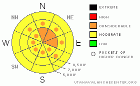
BOTTOM LINE
Danger by aspect and elevation on slopes approaching 35° or steeper.
(click HERE for tomorrow's danger rating)
|
Danger Rose Tutorial
|
This morning there's a level 2 or Moderate danger in the Logan Zone. Heightened avalanche conditions exist, and dangerous triggered avalanches are possible. Increasing northwest winds and continued snowfall will cause the danger to rise to level 3 or Considerable today, especially in upper elevation terrain exposed to drifting. Large and destructive deep slab avalanches remain possible on isolated slopes with generally shallow snow and poor snow structure, especially on very steep slopes facing the northern half of the compass. Evaluate the snow and terrain carefully, and avoid drifted slopes at upper elevations and steep slopes facing the northern half of the compass with poor snow structure. Once again, you'll find safer conditions in sheltered areas, on south facing slopes, and in lower angled terrain.. |
|
|
CURRENT CONDITIONS |

|
The Tony Grove Snotel reports 4 inches of new snow from overnight containing 4/10ths of an inch of water. It's 16 degrees up at the 8400' Tony Grove Snotel, and there is 72 inches of total snow on the ground containing 78% of normal water for the date. Looks like a consistent blanketing across the zone. Beaver Mountain also reports 4 inches as do most other Bear River Range snow sites, and I shoveled about 4" off the walk in West Logan this morning.... The Campbell Scientific Logan Peak weather station at 9700' reports a chilly 7 degrees this morning, with northwest winds averaging only around 8 mph this morning. More snowfall and increasing winds will cause a rising avalanche danger in the backcountry. |
|
|
RECENT ACTIVITY |

|
Riders triggered a good sized hard slab yesterday in the Western Uinta Range, and we've received reports of an interesting rider triggered avalanche on Thursday near Strawberry Reservoir, in which a rider activated his air bag after he was caught...
Locally: Earlier in the week, we triggered a couple large audible collapses in lightly traveled mid elevation northwest facing terrain with a generally thin snowpack. Very weak faceted snow or depth hoar still plagues many slopes in the area, and dangerous hard slab avalanches are still quite possible in isolated areas.
(go to our current conditions page for more details on local activity and reports of other recent avalanches in Utah) |
|
|
THREAT #1 |

|
| WHERE |
PROBABILITY |
SIZE |
TREND |
|
|
|
|
| |
|
|
Over the next
24 hours.
|
|
|
Any increase in wind will rapidly cause a rising danger of wind slabs in upper elevation areas exposed to drifting. In many cases, drifts will build up on top of shallowly buried suspect weak snow that was on the surface in early February. A couple layers of feathery surface hoar crystals and widespread small sugary near surface facet grains were preserved by the light snowfalls in the last week or so. Soft wind slabs today could be up to around a foot deep and will rapidly become deeper with a forecast increase in west and northwest winds today and tonight. Wind slabs will form on the lee sides of major ridge lines and in and around terrain features like sub-ridges, gullies, scoops, and cliff bands. Expect to find developing and dangerous avalanche conditions in drifted terrain by this evening... |
|
|
THREAT #2 |

|
| WHERE |
PROBABILITY |
SIZE |
TREND |

|
|
|
|
| |
|
|
Over the next
24 hours.
|
|
|
Continuing snowfall today will cause a rising danger of storm snow avalanches on steep slopes with preexisting weak layers, which are fairly widespread across the zone. The weight of the new snow, especially if more than expected falls today, may be enough to activate shallowly buried weak layers, and soft slab avalanches will become increasingly likely... |
|
|
THREAT #3 |

|
| WHERE |
PROBABILITY |
SIZE |
TREND |
|
|
|
|
| |
|
|
Over the next
24 hours.
|
|
|
It is possible that a shallow wind slab or storm snow avalanche overrunning a slope with poor snow structure could cause a much larger and more dangerous deep slab avalanche...
You still might trigger a dangerous hard slab avalanche on a very steep slope facing the northern half of the compass, particularly in areas with generally shallow snow... Watch for and avoid shallow or rocky terrain at upper and mid elevations, and keep in mind that you are most likely to trigger a hard slab avalanche from an area where the slab layer is relatively thin. Large audible collapses or whumpfing, like those my party triggered earlier in the week, indicate the presence of a persistent weak layer and potentially very unstable snow. It is possible the weight of a single person could be enough to trigger a large avalanche, and you might trigger one remotely, from a distance or below. Other slopes will need a bigger trigger or someone to hit the so called, "sweet spot", probably from a shallower part of the slab, which could cause an entire bowl to avalanche even if there are already tracks in it.... |
|
|
MOUNTAIN WEATHER |

|
Continuing snowfall is likely today with 2 to 4 inches of accumulation forecast...It will be quite chilly with 8000' high temperatures of 11 degrees and increasing west northwest winds. Breezy conditions will continue tonight, with northwest winds and low temperatures in the single digits. It will be cold and cloudy again tomorrow on Washington's Birthday, with winds shifting from the southwest and increasing a bit.... Another round of snowfall is expected in the early part of next week, beginning Monday night and continuing through Wednesday..... |
|
|
GENERAL ANNOUNCEMENTS |
Please consider a donation to your favorite non-profit –The Friends of the Utah Avalanche Center. The Utah Avalanche Center depends on contributions from users like you to support our work.....
Please send us your observations from the backcountry especially if you see or trigger an avalanche, but also even if you don't.. go to avalanche and snow observations. You can also call me directly at 435-757-7578 or leave us a message at our office, 801-524-5304.... And, you can always send us a simple email by clicking HERE
I will update this advisory by around 7:30 in the morning on Mondays, Wednesdays, Fridays, and Saturdays.....
This advisory is from the U.S.D.A. Forest Service, which is solely responsible for its content. This advisory describes general avalanche conditions and local variations always occur. |
|
|
This information does not apply to developed ski areas or highways where avalanche control is normally done. This advisory is from the U.S.D.A. Forest Service, which is solely responsible for its content. This advisory describes general avalanche conditions and local variations always occur. |
|
This advisory provided by the USDA Forest Service, in partnership with:
The Friends of the Utah Avalanche Center, Utah Division of State Parks and Recreation, Utah Division of Emergency Management, Salt Lake County, Salt Lake Unified Fire Authority and the friends of the La Sal Avalanche Center. See our Sponsors Page for a complete list. |
