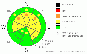
BOTTOM LINE
Danger by aspect and elevation on slopes approaching 35° or steeper.
(click HERE for tomorrow's danger rating)
|
Danger Rose Tutorial
|
There's a level 2 or Moderate danger in the Logan Zone. Heightened avalanche conditions persist, and dangerous triggered avalanches are possible. I've included a few pockets with a level 3 or Considerable danger, and you might trigger large and destructive deep slab avalanches on isolated steep slopes with generally shallow snow and poor snow structure, especially on very steep slopes facing the northern half of the compass. . Also today, you could trigger shallow wind slab avalanches in upper elevation terrain exposed to drifting. Evaluate the snow and terrain carefully and continue to avoid very steep slopes facing the northern half of the compass and drifted slopes at upper elevations. Once again, you'll find safer conditions in sheltered areas, on south facing slopes, at lower elevations, and in lower angled terrain.. |
|
|
CURRENT CONDITIONS |

|
We found nice fast shallow powder conditions on all aspects at upper elevations yesterday in the Tony Grove Area. Riding conditions are good and smooth, with mostly supportable snow under several inches of fluffy powder, and you can ride almost anywhere you want to.. The nice new snow is much shallower down low and the sunny slopes probably sport a bit of a crust after yesterday's strong sun, but the older snow is mostly supportable and conditions are still pretty enjoyable... Certainly still good and fast on much safer lower angled terrain... It's 20 degrees up at the 8400' Tony Grove Snotel, and there is 70 inches of total snow on the ground containing 78% of normal water for the date. The site reported 2 inches of new snow from overnight and 5"on Wednesday. The Campbell Scientific Logan Peak weather station at 9700' reports 11 degrees this morning, with west winds averaging a bit over 20 mph... |
|
|
RECENT ACTIVITY |

|
We could see evidence of numerous loose dry avalanches or sluffs yesterday on steep slopes at upper elevations in the Tony Grove Area. One of these, in Castle Rock, looks to have stepped down to last week's surface, perhaps taking out a shallow soft slab as it ran. I also received a report from a rancher who heard a large avalanche from his fields in Petersboro yesterday afternoon. The unmistakable noise, which he's heard in the past when large avalanches run in the area, came from somewhere in the Northern Wellsville Range...
(go to our current conditions page for more details on local activity and reports of other recent avalanches in Utah) |
|
|
THREAT #1 |

|
| WHERE |
PROBABILITY |
SIZE |
TREND |
|
|
|
|
| |
|
|
Over the next
24 hours.
|
|
|
The probability of deadly deep slab avalanches in steep terrain continues to gradually diminish, but there is still a small chance that you could trigger one, and the consequences of being caught are still just as deadly as they have been. You still could trigger one of these monsters on very steep northerly facing slopes, particularly in areas with generally shallow snow... Watch for and avoid shallow or rocky terrain at upper elevations, and keep in mind that you are most likely to trigger a hard slab avalanche from an area where the slab layer is fairly thin, ( around 2' deep or less). In some cases, most likely in very lightly traveled areas, the weight of a single person could be enough to trigger a large avalanche, and you could trigger one remotely, from a distance or below. Deep slabs now will likely need a larger trigger like a big cornice fall or the weight of a few sleds at once on a slope to avalanche. It is possible in these conditions that a dangerous avalanche could occur even on a slope that has several sets of tracks in it, or that the fourth or fifth or tenth person to climb a steep hill could find the so called "sweet spot" and trigger the entire bowl..... |
|
|
THREAT #2 |

|
| WHERE |
PROBABILITY |
SIZE |
TREND |

|
|
|
|
| |
|
|
Over the next
24 hours.
|
|
|
You'll find shallow wind slabs in upper elevation areas exposed to drifting. In many cases these built up on top of suspect weak snow that was on the surface last week . Both feathery surface hoar crystals and small sugary near surface facet grains were noted just under the fresh snow surface in the last couple days. Soft wind slabs today could be up to around a foot deep and are most likely on the lee sides of major ridge lines and in and around terrain features like sub-ridges, gullies, scoops, and cliff bands. It is possible that a shallow wind slab overrunning a slope with poor snow structure could cause a much larger and more dangerous deep slab avalanche... |
|
|
MOUNTAIN WEATHER |

|
Cloudy conditions this morning should give way to clearing and a bit of sunshine later in the afternoon. Expect 8500' high temperatures in the mid twenties and moderate west winds of around 20 mph along the highest ridges. We might see a snow flake or two, but little in the way of accumulation. Clouds will increase again overnight tonight and moderate northwest winds will shift around from the southwest, with low temperatures of around 15 degrees... An energetic and cold storm system will begin to affect the zone tomorrow, with temperatures a few degrees warmer, intensifying southwest winds, and some snowfall... Snowfall will become heavy at times tomorrow night and Sunday, and it is likely to continue through Monday. 6 to 12 inches of accumulation is currently forecast by Sunday afternoon, and more is certainly possible.... This storm will cause a general increase in backcountry avalanche danger in the Logan Zone and across the state.... |
|
|
GENERAL ANNOUNCEMENTS |
Please consider a donation to your favorite non-profit –The Friends of the Utah Avalanche Center. The Utah Avalanche Center depends on contributions from users like you to support our work.....
Please send us your observations from the backcountry especially if you see or trigger an avalanche, but also even if you don't.. go to avalanche and snow observations. You can also call me directly at 435-757-7578 or leave us a message at our office, 801-524-5304.... And, you can always send us a simple email by clicking HERE
I will update this advisory by around 7:30 in the morning on Mondays, Wednesdays, Fridays, and Saturdays.....
This advisory is from the U.S.D.A. Forest Service, which is solely responsible for its content. This advisory describes general avalanche conditions and local variations always occur. |
|
|
This information does not apply to developed ski areas or highways where avalanche control is normally done. This advisory is from the U.S.D.A. Forest Service, which is solely responsible for its content. This advisory describes general avalanche conditions and local variations always occur. |
|
This advisory provided by the USDA Forest Service, in partnership with:
The Friends of the Utah Avalanche Center, Utah Division of State Parks and Recreation, Utah Division of Emergency Management, Salt Lake County, Salt Lake Unified Fire Authority and the friends of the La Sal Avalanche Center. See our Sponsors Page for a complete list. |
