SPECIAL ANNOUNCEMENT |
 |
The Friends of the Utah Avalanche Center in Logan is hosting an Advanced Avalanche Awareness class this Thursday Feb 16 and Saturday Feb 18. For details click here...CLASS |
|
|
BOTTOM LINE
Danger by aspect and elevation on slopes approaching 35° or steeper.
(click HERE for tomorrow's danger rating)
|
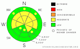
Danger Rose Tutorial
|
There's a level 2 or Moderate danger in the Logan Zone. Heightened avalanche conditions persist, and dangerous triggered avalanches are possible. You still might trigger large and destructive deep slab avalanches on isolated steep slopes with poor snow structure, especially on very steep slopes facing the northern half of the compass. You are most likely to trigger one of these monsters in rocky areas with generally shallow snow cover, and you could trigger a deep slab from an area where the slab is relatively thin... Also today, you could trigger shallow wind slab avalanches in upper elevation terrain exposed to drifting. Evaluate the snow and terrain carefully and continue to avoid very steep slopes facing the northern half of the compass and drifted slopes at upper elevations. Once again, you'll find safer conditions in sheltered areas, on south facing slopes, at lower elevations, and in lower angled terrain.. |
|
|
CURRENT CONDITIONS |

|
Warm temperatures from the weekend crusted lower elevation snow, but you can still find fine shallow powder riding conditions at upper and mid elevations, especially on shady sheltered slopes. Lower angled terrain is still my preferred option, since the soft snow is nice and fast and I don't have to worry so much about dangerous avalanches on slopes less steep than around 30 degrees... It's 20 degrees up at the 8400' Tony Grove Snotel, and there is 68 inches of total snow on the ground containing 79% of normal water for the date. The site reported one inch of new snow from overnight. The Campbell Scientific Logan Peak weather station at 9700' reports 14 degrees this morning, with light southwest winds and possible rime issues. Southwest winds averaged in the teens with gusts to 25 mph on Mt Ogden overnight. |
|
|
RECENT ACTIVITY |

|
No significant avalanches were reported in the Logan Zone in over a week. Over the weekend. a small wet avalanche was reported from lower Providence Canyon caused by Saturday's lower elevation warmth.. It's been three weeks now since the last very dangerous triggered deep slab was reported in the zone....
(go to our current conditions page for more details on local activity and reports of other recent avalanches in Utah) |
|
|
THREAT #1 |

|
| WHERE |
PROBABILITY |
SIZE |
TREND |
|
|
|
|
| |
|
|
Over the next
24 hours.
|
|
|
The probability of deadly deep slab avalanches in steep terrain continues to gradually diminish, but there is still a small chance that you could trigger one, and the consequences of being caught are still just as deadly as they have been. You still could trigger one of these monsters on very steep northerly facing slopes, particularly in areas with generally shallow snow... Watch for and avoid shallow or rocky terrain at upper elevations, and keep in mind that you are most likely to trigger a hard slab avalanche from an area where the slab layer is fairly thin, ( around 2' deep or less). In some cases, most likely in very lightly traveled areas, the weight of a single person could be enough to trigger a large avalanche, and you could trigger one remotely, from a distance or below. Deep slabs now will likely need a larger trigger like a big cornice fall or the weight of a few sleds at once on a slope to avalanche. It is possible in these conditions that a dangerous avalanche could occur even on a slope that has several sets of tracks in it, or that the fourth or fifth or tenth person to climb a steep hill could find the so called "sweet spot" and trigger the entire bowl..... |
|
|
THREAT #2 |

|
| WHERE |
PROBABILITY |
SIZE |
TREND |
|
|
|
|
| |
|
|
Over the next
24 hours.
|
|
|
Even with fairly light winds and modest fresh snow, shallow wind slabs formed in upper elevation areas exposed to drifting on top of suspect weak snow that was on the surface last week . Both feathery surface hoar crystals and small sugary near surface facet grains were noted just under the fresh snow surface in the last couple days. Soft wind slabs today could be up to around a foot deep and are most likely on the lee sides of major ridge lines and in and around terrain features like sub-ridges, gullies, scoops, and cliff bands. |
|
|
MOUNTAIN WEATHER |

|
Expect a little snow in morning, with light accumulations of less than an inch forecast. Expect 8500' high temperatures around 22 degrees, a fairly light northwesterly breeze, and a little sunshine is possible this afternoon.... It'll be mostly clear overnight, with low temperatures hovering in the lower teens and moderate northwest winds. We'll see increasing cloudiness tomorrow and high temperatures in the mid twenties... A storm system will affect areas to our north over the weekend, and it's looking more likely that it will graze northern Utah... Don't get your hopes up, but it is possible that the energetic and cold storm will take a more southerly path, and we could see significant snowfall.... Stay tuned for more details and developments on this as the weekend approaches.... |
|
|
GENERAL ANNOUNCEMENTS |
Please consider a donation to your favorite non-profit –The Friends of the Utah Avalanche Center. The Utah Avalanche Center depends on contributions from users like you to support our work.....
Please send us your observations from the backcountry especially if you see or trigger an avalanche, but also even if you don't.. go to avalanche and snow observations. You can also call me directly at 435-757-7578 or leave us a message at our office, 801-524-5304.... And, you can always send us a simple email by clicking HERE
I will update this advisory by around 7:30 in the morning on Mondays, Wednesdays, Fridays, and Saturdays.....
This advisory is from the U.S.D.A. Forest Service, which is solely responsible for its content. This advisory describes general avalanche conditions and local variations always occur. |
|
|
This information does not apply to developed ski areas or highways where avalanche control is normally done. This advisory is from the U.S.D.A. Forest Service, which is solely responsible for its content. This advisory describes general avalanche conditions and local variations always occur. |
|
This advisory provided by the USDA Forest Service, in partnership with:
The Friends of the Utah Avalanche Center, Utah Division of State Parks and Recreation, Utah Division of Emergency Management, Salt Lake County, Salt Lake Unified Fire Authority and the friends of the La Sal Avalanche Center. See our Sponsors Page for a complete list. |
