SPECIAL ANNOUNCEMENT |
 |
The Friends of the Utah Avalanche Center in Logan is hosting an Advanced Avalanche Awareness class this Thursday Feb 16 and Saturday Feb 18. For details click here...CLASS |
|
|
BOTTOM LINE
Danger by aspect and elevation on slopes approaching 35° or steeper.
(click HERE for tomorrow's danger rating)
|
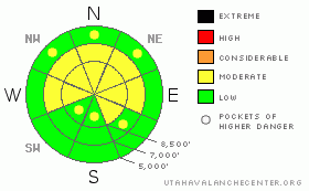
Danger Rose Tutorial
|
There's a level 2 or Moderate danger in the Logan Zone. Heightened avalanche conditions persist, and triggered avalanches are possible. You still might trigger dangerous deep slab avalanches on isolated steep slopes with poor snow structure, especially on very steep slopes facing the northern half of the compass and in areas with generally shallow snow cover.. Also today, you could trigger shallow wind slab avalanches in upper elevation terrain exposed to drifting. Evaluate the snow and terrain carefully and continue to avoid very steep slopes facing the northern half of the compass and drifted slopes at upper elevations. You'll find safer conditions in sheltered areas, on south facing slopes, at lower elevations, and in lower angled terrain.. |
|
|
CURRENT CONDITIONS |

|
The shallow new snow is pretty fast and lower angled terrain continues to offer the best riding conditions. A layer consisting of small weak sugary faceted grains and/or feathery surface hoar can be found preserved just under the few inches of last week's new snow in most shady areas.. There's a weak sun-crust on more sun exposed slopes, capping a thin layer of small weak sugary grains.
The Campbell Scientific Logan Peak weather station at 9700' reports 16 degrees this morning, with light and diminishing northwest winds. Looks like the wind sensor was rimed early this morning. West winds are averaging in the teens and gusting to 25 mph on Mt Ogden this morning. It's 23degrees up at the 8400' Tony Grove Snotel, and there is 68 inches of total snow on the ground containing 80% of normal water for the date. The site only reported another angry inch of new snow from yesterday containing only 1/10th of an inch of water. |
|
|
RECENT ACTIVITY |

|
Locally: A small wet avalanche was reported at lower elevations in Providence Canyon probably from Saturday.. It's been almost three weeks now since any very dangerous deep slabs were reported in the zone. ...
(go to our current conditions page for more details on local activity and reports of other recent avalanches in Utah) |
|
|
THREAT #1 |

|
| WHERE |
PROBABILITY |
SIZE |
TREND |
|
|
|
|
| |
|
|
Over the next
24 hours.
|
|
|
The probability of deadly deep slab avalanches in steep terrain continues to gradually diminish, but there is still a small chance that you could trigger one, especially on very steep northerly facing slopes with generally shallow snow, and the consequences of being caught are still just as severe. Deep slabs now will likely need a larger trigger like a big cornice fall or the weight of a few sleds at once on a slope to avalanche. Although growing more unlikely in most areas, It is possible that a dangerous avalanche could occur even on a slope that has several sets of tracks in it, or that the fourth or fifth or tenth person to climb a steep hill could find the so called "sweet spot" and trigger the entire bowl..... |
|
|
THREAT #2 |

|
| WHERE |
PROBABILITY |
SIZE |
TREND |
|
|
|
|
| |
|
|
Over the next
24 hours.
|
|
|
Even with fairly light winds yesterday and overnight, shallow wind slabs have formed on top of weak snow that was on the surface earlier in the week in upper elevation areas exposed to drifting . Both feathery surface hoar crystals and small sugary near surface facet grains were noted just under the fresh snow surface in the last couple days. Soft wind slabs today could be up to around a foot deep and are most likely on the lee sides of major ridge lines and in and around terrain features like sub-ridges, gullies, scoops, and cliff bands. |
|
|
MOUNTAIN WEATHER |

|
Expect mostly cloudy weather today, with 8500' high temperatures around 25 degrees, a light westerly breeze, and a few snowflakes, but little in the way of accumulation.. The next Pacific storm will impact the region starting tonight, but the track looks similar to yesterday's except it may well head even farther to the south. We might see a little more snow tonight and tomorrow morning, but again accumulations will be on the very light side up here in the Far North. An inch or two is possible on Wednesday, we should see some sunshine Thursday and again Friday, and a storm system to our north could graze the Logan Zone as we head into next weekend.... |
|
|
GENERAL ANNOUNCEMENTS |
Please consider a donation to your favorite non-profit –The Friends of the Utah Avalanche Center. The Utah Avalanche Center depends on contributions from users like you to support our work.....
Please send us your observations from the backcountry especially if you see or trigger an avalanche, but also even if you don't.. go to avalanche and snow observations. You can also call me directly at 435-757-7578 or leave us a message at our office, 801-524-5304.... And, you can always send us a simple email by clicking HERE
I will update this advisory by around 7:30 in the morning on Mondays, Wednesdays, Fridays, and Saturdays.....
This advisory is from the U.S.D.A. Forest Service, which is solely responsible for its content. This advisory describes general avalanche conditions and local variations always occur. |
|
|
This information does not apply to developed ski areas or highways where avalanche control is normally done. This advisory is from the U.S.D.A. Forest Service, which is solely responsible for its content. This advisory describes general avalanche conditions and local variations always occur. |
|
This advisory provided by the USDA Forest Service, in partnership with:
The Friends of the Utah Avalanche Center, Utah Division of State Parks and Recreation, Utah Division of Emergency Management, Salt Lake County, Salt Lake Unified Fire Authority and the friends of the La Sal Avalanche Center. See our Sponsors Page for a complete list. |
