SPECIAL ANNOUNCEMENT |
|
|
|
BOTTOM LINE
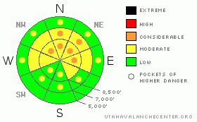
Danger by aspect and elevation on slopes approaching 35° or steeper.
(click HERE for tomorrow's danger rating)
|
Danger Rose Tutorial
|
Heightened avalanche conditions persist, and overall there's a level 2 or Moderate danger in the Logan Zone, with triggered avalanches possible. There are also still a few pockets with a level 3 or Considerable danger at upper and mid elevations, illustrating a lingering danger of potentially deadly deep slab avalanches. You still might trigger dangerous deep slab avalanches on isolated steep slopes with poor snow structure, especially on very steep slopes facing the northern half of the compass and in areas with generally shallow snow cover.. Also today, you could trigger shallow wind slab avalanches in terrain exposed to drifting or shallow wet sluffs on steep slopes with moist surface snow. Careful snowpack evaluation, cautious route-finding, and conservative decision-making will again be essential in the backcountry this weekend. You'll find safer conditions in sheltered areas, on south facing slopes, and in lower angled terrain.. |
|
|
CURRENT CONDITIONS |

|
The Campbell Scientific Logan Peak weather station at 9700' reports 23 degrees this morning, with southwest winds averaging in the mid-teens. It's 27 degrees up at the 8400' Tony Grove Snotel, and there is 68 inches of total snow on the ground containing 81% of normal water for the date. The site only reported an inch of new snow from yesterday containing 3/10s of an inch of water. Sheltered lower angled terrain continues to offer the best riding conditions. Supportable snow allows you to ride almost anywhere you want to go, but there is still significant risk of hitting rocks, especially in lower elevation meadows and in west or south facing terrain where the existing snow is still pretty shallow. A few inches of new snow from the couple days now caps a variable surface, with supportable and breakable sun crusts on sunny slopes and shallowly buried wind boards, crusts, and sastrugi in exposed upper elevation terrain. A layer consisting of small weak sugary or faceted grains can be found preserved just under the few inches of new snow in many areas... |
|
|
RECENT ACTIVITY |

|
Locally: No avalanches were reported in the Logan Zone since last Friday, when riders triggered shallow wind slabs in Franklin Basin and Providence Canyon... And, its been more than two weeks now since any very dangerous deep slabs were triggered in the zone. Reported audible collapses Thursday on low angled north facing terrain at mid elevations indicate lingering unstable snow in some areas....
(go to our current conditions page for more details on local activity and reports of other recent avalanches in Utah) |
|
|
THREAT #1 |

|
| WHERE |
PROBABILITY |
SIZE |
TREND |
|
|
|
|
| |
|
|
Over the next
24 hours.
|
|
|
The probability of deadly deep slab avalanches in steep terrain continues to gradually diminish, but there is still a chance that you could trigger one, especially on very steep north facing slopes with generally shallow snow in the zone, and the consequences of being caught are still just as severe. Reported collapsing Thursday indicates that potential for deep slab avalanches certainly persists. Deep hard slab avalanches could range from 2 to 6 feet deep and they could be fairly wide. In some cases, and in lightly traveled terrain, avalanches could still be very sensitive or easy to trigger, and the weight of a single person might trigger one remotely, perhaps even from below. Other hard deep slabs might be much more stubborn and will take a larger trigger like a big cornice fall or the weight of a few sleds at once on a slope to avalanche. It is possible that an avalanche could occur even on a slope that has several sets of tracks in it, or that the fourth or fifth person to climb a hill could find the so called "sweet spot" and trigger the entire bowl..... |
|
|
THREAT #2 |

|
| WHERE |
PROBABILITY |
SIZE |
TREND |
|
|
|
|
| |
|
|
Over the next
12 hours.
|
|
|
With west winds yesterday and overnight, shallow wind slabs formed in areas exposed to drifting on top of weak snow that was on the surface earlier in the week. Both feathery surface hoar crystals and small sugary near surface facet grains were noted on or just under the fresh snow surface in the last several days. Wind slabs today could be around a foot deep, with width dependent on terrain. Wind slab avalanches are most likely on the lee sides of major ridge lines and in and around terrain features like sub-ridges, gullies, scoops, and cliff bands. Smaller wind slab avalanches overrunning a slope with poor snow structure could trigger much larger and more dangerous deep slab avalanches..... |
|
|
THREAT #3 |

|
| WHERE |
PROBABILITY |
SIZE |
TREND |
|
|
|
|
| |
|
|
Over the next
12 hours.
|
|
|
We're expecting warmer temperatures in the mountains today. Watch for moist sluffs on steep slopes with warmth-dampened surface snow.... |
|
|
MOUNTAIN WEATHER |

|
A ridge of high pressure is overhead this morning, but it will move eastward today as the next splitting storm enters the state from the northwest... We might see a bit of sunshine this morning, and mountain temperatures will be fairly mild, with 8500' highs around 35 degrees. Clouds will move in for the afternoon and a few snow showers are possible along with moderate southwest winds.. We'll pick up an inch or two of accumulation tonight and another inch tomorrow, but most of the moisture with this storm will stay to our south and east.... Another similar storm will move through the zone Monday night and Tuesday, with only light accumulation expected again in Far Northern Utah. |
|
|
GENERAL ANNOUNCEMENTS |
Please consider a donation to your favorite non-profit –The Friends of the Utah Avalanche Center. The Utah Avalanche Center depends on contributions from users like you to support our work.....
Please send us your observations from the backcountry especially if you see or trigger an avalanche, but also even if you don't.. go to avalanche and snow observations. You can also call me directly at 435-757-7578 or leave us a message at our office, 801-524-5304.... And, you can always send us a simple email by clicking HERE
I will update this advisory by around 7:30 in the morning on Mondays, Wednesdays, Fridays, and Saturdays.....
This advisory is from the U.S.D.A. Forest Service, which is solely responsible for its content. This advisory describes general avalanche conditions and local variations always occur. |
|
|
This information does not apply to developed ski areas or highways where avalanche control is normally done. This advisory is from the U.S.D.A. Forest Service, which is solely responsible for its content. This advisory describes general avalanche conditions and local variations always occur. |
|
This advisory provided by the USDA Forest Service, in partnership with:
The Friends of the Utah Avalanche Center, Utah Division of State Parks and Recreation, Utah Division of Emergency Management, Salt Lake County, Salt Lake Unified Fire Authority and the friends of the La Sal Avalanche Center. See our Sponsors Page for a complete list. |
