SPECIAL ANNOUNCEMENT |
 |
The Friends of the Utah Avalanche Center in Logan are offering a Backcountry 101 class for women next weekend... The class will start with a classroom session on Thursday night (Feb.9th) and include a full field day session on Saturday (Feb. 11th) up in the Garden City Bowls near the Hwy 89 summit in Logan Canyon... It's a great time to learn about snow and avalanches..... Click HERE for more details... |
|
|
BOTTOM LINE
Danger by aspect and elevation on slopes approaching 35° or steeper.
(click HERE for tomorrow's danger rating)
|
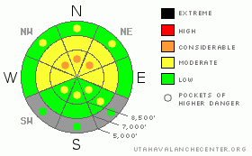
Danger Rose Tutorial
|
Heightened avalanche conditions exist, and there's a level 2 or Moderate danger on upper and mid elevation slopes, especially those with recent deposits of drifted snow. You could trigger wind slab avalanches in exposed terrain. There are also still lingering pockets with a level 3 or Considerable danger, and dangerous deep slab avalanches are possible on isolated slopes with poor snow structure, especially on very steep upper elevation slopes facing the northern third of the compass. Careful snowpack evaluation, cautious route-finding, and conservative decision-making will again be essential in the backcountry, especially in terrain exposed to drifting. You'll find safer conditions in sheltered areas, on south facing slopes, and in lower angled terrain.. |
|
|
CURRENT CONDITIONS |

|
You'll find some nice shallow and fast recrystallized snow or "loud powder" in the backcountry today, and sheltered lower angled terrain will probably offer the best conditions. Don't forget to pack the goggles, because a bit of snowfall is likely throughout the day. Supportable snow allows you to ride almost anywhere you want to go, but there is still significant risk of hitting rocks where the snow remains shallow, especially in lower elevation meadows and in west or south facing terrain. Sunny and off aspect slopes sport a variable, and in some areas a nasty breakable crust. The Campbell Scientific Logan Peak weather station at 9700' reports 16 degrees this morning, with southwest winds averaging a bit less than 20 mph this morning after maintaining 30 mph averages from the south late last night. It's 25 degrees up at the 8400' Tony Grove Snotel, and there is 67 inches of total snow on the ground containing 80% of normal water for the date. |
|
|
RECENT ACTIVITY |

|
A rider was killed by a large hard slab avalanche triggered by his party near Fish Lake on Sunday evening. An accident report is posted on our Web-site. Click HERE
Locally: No avalanches were reported in the Logan Zone since last Friday, when riders triggered shallow wind slabs in Franklin Basin and Providence Canyon... And, its been two whole weeks now since any very dangerous deep slabs were triggered in the zone, with a broad remote triggered hard slab in the Rodeo Grounds on the east side of Logan Peak the last, on January 25th.
(go to our current conditions page for more details on local activity and reports of other recent avalanches in Utah) |
|
|
THREAT #1 |

|
| WHERE |
PROBABILITY |
SIZE |
TREND |
|
|
|
|
| |
|
|
Over the next
24 hours.
|
|
|
The probability of deadly deep slab avalanches in steep terrain continues to gradually diminish, but there is still a chance that you could trigger one, especially on very steep north facing slopes in the zone, and the consequences of being caught are still just as severe. Deep hard slab avalanches could range from 2 to 6 feet deep and they could be quite wide. In some cases and in lightly traveled terrain, avalanches could still be very sensitive or easy to trigger, and the weight of a single person might trigger one remotely, perhaps even from below. Other hard slabs might be much more stubborn and will take a larger trigger like a big cornice fall or the weight of a few sleds at once on a slope to avalanche. |
|
|
THREAT #2 |

|
| WHERE |
PROBABILITY |
SIZE |
TREND |
|
|
|
|
| |
|
|
Over the next
12 hours.
|
|
|
With south and southwest winds overnight, shallow stiff wind slabs probably formed in some exposed areas on top of weak snow that was on the surface. Both feathery surface hoar crystals and small sugary near surface facet grains were noted on the snow surface in the last several days. Wind slabs today could be around a foot deep, with width dependent on terrain. Today's fresh snow will be prone to drifting, and sensitive soft slabs will continue to develop. Wind slab avalanches are most likely on the lee sides of major ridge lines and in and around terrain features like sub-ridges, gullies, scoops, and cliff bands. Smaller wind slab avalanches overrunning a slope with poor snow structure could trigger much larger and more dangerous deep slab avalanches..... |
|
|
MOUNTAIN WEATHER |

|
Expect a couple inches of accumulation today as a weak and splitting but moist storm spreads into the state.... Light snowfall will last through much of the day in the mountains, with temperatures in the mid twenties and a moderate southwest wind. Snowfall will likely continue into the evening hours and winds will shift from the northwest, but little additional accumulation is expected. We should see clearing tomorrow and a bit of sunshine by afternoon, a moderate northwest wind, and temperatures in the upper twenties.... More splitting storms will bring small quantities of snow later in the weekend and into early next week, but nothing significant is in sight.... |
|
|
GENERAL ANNOUNCEMENTS |
Please consider a donation to your favorite non-profit –The Friends of the Utah Avalanche Center. The Utah Avalanche Center depends on contributions from users like you to support our work.....
Please send us your observations from the backcountry especially if you see or trigger an avalanche, but also even if you don't.. go to avalanche and snow observations. You can also call me directly at 435-757-7578 or leave us a message at our office, 801-524-5304.... And, you can always send us a simple email by clicking HERE
I will update this advisory by around 7:30 in the morning on Mondays, Wednesdays, Fridays, and Saturdays.....
This advisory is from the U.S.D.A. Forest Service, which is solely responsible for its content. This advisory describes general avalanche conditions and local variations always occur. |
|
|
This information does not apply to developed ski areas or highways where avalanche control is normally done. This advisory is from the U.S.D.A. Forest Service, which is solely responsible for its content. This advisory describes general avalanche conditions and local variations always occur. |
|
This advisory provided by the USDA Forest Service, in partnership with:
The Friends of the Utah Avalanche Center, Utah Division of State Parks and Recreation, Utah Division of Emergency Management, Salt Lake County, Salt Lake Unified Fire Authority and the friends of the La Sal Avalanche Center. See our Sponsors Page for a complete list. |
