SPECIAL ANNOUNCEMENT |
 |
The Friends of the Utah Avalanche Center in Logan are offering a Backcountry 101 class for women next weekend... The class will start with a classroom session on Thursday night (Feb.9th) and include a full field day session on Saturday (Feb. 11th) up in the Garden City Bowls near the Hwy 89 summit in Logan Canyon... It's a great time to learn about snow and avalanches..... Click HERE for more details... |
|
|
BOTTOM LINE
Danger by aspect and elevation on slopes approaching 35° or steeper.
(click HERE for tomorrow's danger rating)
|
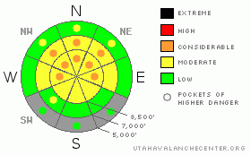
Danger Rose Tutorial
|
Heightened avalanche conditions exist, and there's a level 2 or Moderate danger on upper and mid elevation slopes, especially those with recent deposits of drifted snow. You could trigger lingering wind slabs in drifted areas, and drifting occurred recently in somewhat unusual places. There are also still many areas with pockets of level 3 or Considerable danger, and dangerous deep slab avalanche conditions persist on slopes with poor snow structure, especially on very steep upper and mid elevation slopes facing the northern half of the compass. While it is growing more unlikely that you will trigger one of these dragons, doing so could well be fatal. Careful snowpack evaluation, cautious route-finding, and conservative decision-making will again be essential in the backcountry today, and you should continue to avoid steep drifted slopes at upper and mid elevations. You'll find safer conditions in sheltered areas, on south facing slopes, in lower angled terrain, and at lower elevations. |
|
|
CURRENT CONDITIONS |

|
Riding conditions are pretty good, with nice supportable snow allowing you to ride almost anywhere you want to go, but there is still some potential of hitting rocks, especially in lower elevation meadows.. You can still find plenty of enjoyable and fast shallow powder in sheltered areas facing the northern half of the compass, and lower angled slopes are both fun and much less dangerous than steeper terrain. Sunny and off aspect slopes sport a variable and in some areas nasty breakable crust. The Campbell Scientific Logan Peak weather station at 9700' reports 12 degrees this morning, with light northwest winds averaging in the single digits. It's 17degrees up at the 8400' Tony Grove Snotel, and there is 69 inches of total snow on the ground containing 81% of normal water for the date. |
|
|
RECENT ACTIVITY |

|
There were a few new avalanches reported in northern Utah over the weekend, including a couple remote triggered large hard slabs, which were triggered by sledders.... We also received several reports of large audible collapses or whumphfs, which indicate persisting instability... Locally: Despite good crowds in the backcountry, no avalanches were reported from over the weekend. In fact, we received no reports at all from the Logan Zone. There were a couple good sized unintentionally rider triggered wind slab avalanches in the zone on Friday, and thankfully nobody was caught..
(go to our current conditions page for more details on local activity and reports of other recent avalanches in Utah) |
|
|
THREAT #1 |

|
| WHERE |
PROBABILITY |
SIZE |
TREND |
|
|
|
|
| |
|
|
Over the next
24 hours.
|
|
|
The probability of deadly deep slab avalanches in steep terrain is gradually diminishing, but the potential persists especially on very steep slopes in the zone, and the consequences of being caught are still quite severe. Deep slab avalanches could range from 2 to 6 feet deep. In some cases, avalanches could still be very sensitive or easy to trigger, and the weight of a single person might trigger them remotely from a distance, or worse, from below. Other hard deep slabs might be much more stubborn and will take a larger trigger like a cornice fall or the weight of a sled or two at once on a slope to avalanche. Hard deep slabs can be quite tricky and could allow you to get out on them before releasing, or they might wait and fail on the second or third or fourth time you climb a slope. Under these conditions obvious signs of instability may well be absent, but still pay close attention to red flags like collapsing and shooting cracks, and reevaluate you route if you encounter any sign of instability. Have patience and continue to avoid very steep or drifted slopes. |
|
|
THREAT #2 |

|
| WHERE |
PROBABILITY |
SIZE |
TREND |
|
|
|
|
| |
|
|
Over the next
12 hours.
|
|
|
Friday's strong east winds created a diminishing danger of wind slab avalanches. Drifts built up on weak snow that was on the surface last week, with both small feathery surface hoar and small near surface facets noted... Wind slabs today could be 1 to 2 feet deep, with width dependent on terrain. Of particular concern are upper elevation west facing slopes, where drifting added weight to slopes with weak structure and shallow snow. Wind slab avalanches are most likely on the lee sides of major ridge lines and in and around terrain features like sub-ridges, gullies, scoops, and cliff bands. Smaller wind slab avalanches overrunning a slope with poor snow structure could trigger much larger and more dangerous deep slab avalanches..... |
|
|
MOUNTAIN WEATHER |

|
The upper level low, that brought cloudy conditions to the zone yesterday, will slowly push east of the area today, and a high pressure system will set up over the area for tomorrow. Mountain high temperatures of around 27 degrees are expected, with calm winds becoming southwesterly today. It will be breezy and clear tonight, with low temperatures of around 12 degrees forecast. There is a chance we might see a little snow Wednesday and Wednesday night, but only minimal amounts of accumulation are forecast. The high pressure will build back in on Thursday and control the weather pattern through the end of the week. Models are still in disagreement regarding the weather for the weekend, with snowfall possible Saturday night and again Monday in the more favorable EC outlook.... |
|
|
GENERAL ANNOUNCEMENTS |
Please consider a donation to your favorite non-profit –The Friends of the Utah Avalanche Center. The Utah Avalanche Center depends on contributions from users like you to support our work.....
Please send us your observations from the backcountry especially if you see or trigger an avalanche, but also even if you don't.. go to avalanche and snow observations. You can also call me directly at 435-757-7578 or leave us a message at our office, 801-524-5304.... And, you can always send us a simple email by clicking HERE
I will update this advisory by around 7:30 in the morning on Mondays, Wednesdays, Fridays, and Saturdays.....
This advisory is from the U.S.D.A. Forest Service, which is solely responsible for its content. This advisory describes general avalanche conditions and local variations always occur. |
|
|
This information does not apply to developed ski areas or highways where avalanche control is normally done. This advisory is from the U.S.D.A. Forest Service, which is solely responsible for its content. This advisory describes general avalanche conditions and local variations always occur. |
|
This advisory provided by the USDA Forest Service, in partnership with:
The Friends of the Utah Avalanche Center, Utah Division of State Parks and Recreation, Utah Division of Emergency Management, Salt Lake County, Salt Lake Unified Fire Authority and the friends of the La Sal Avalanche Center. See our Sponsors Page for a complete list. |
