SPECIAL ANNOUNCEMENT |
 |
The Friends of the Utah Avalanche Center in Logan are offering a Backcountry 101 class for women next weekend... The class will start with a classroom session on Thursday night (Feb.9th) and include a full field day session on Saturday (Feb. 11th) up in the Garden City Bowls near the Hwy 89 summit in Logan Canyon... It's a great time to learn about snow and avalanches..... Click HERE for more details... |
|
|
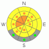
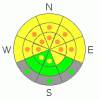
BOTTOM LINE
Danger by aspect and elevation on slopes approaching 35° or steeper.
(click HERE for tomorrow's danger rating)
|
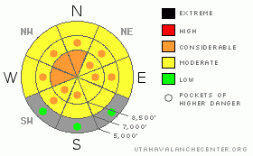
Danger Rose Tutorial
|
There's a level 3 or Considerable danger on upper elevation slopes with recent deposits of drifted snow, where you are likely to trigger wind slabs or dangerous deep slab avalanches. Wind slab avalanches are likely on many recently drifted slopes, and drifting occurred yesterday in somewhat unusual areas. There are also still many areas with pockets of level 3 or Considerable danger, and dangerous deep slab avalanche conditions persist on slopes with poor snow structure, especially on very steep upper and mid elevation slopes facing the northern half of the compass. Careful snowpack evaluation, cautious route-finding, and conservative decision-making will again be essential in the backcountry today, and you should continue to avoid steep drifted slopes at upper and mid elevations. You'll find safer conditions in sheltered areas, on south facing slopes, and at lower elevations, and there's still lots of nice fast and fun snow in lower angled terrain. |
|
|
CURRENT CONDITIONS |

|
Strong and sustained winds from the east found plenty of soft snow to drift about, and we'll find wind slabs and stiff wind deposits in somewhat unusual places again today.You can still find plenty of enjoyable and fast shallow powder in sheltered areas, and lower angled slopes are both fun and much less dangerous than steeper terrain. Riding conditions are pretty good, with nice supportable snow allowing you to ride almost anywhere you want to go...The probability of deadly deep slab avalanches in steep terrain is gradually diminishing, but the potential persists on many steep slopes in the zone, and the consequences of being caught are still quite severe.
It's 15 degrees up at the 8400' Tony Grove Snotel this morning, and it looks like the station picked up an inch of new snow overnight. There is 71 inches of total snow on the ground containing 81% of normal water for the date. The CSI Logan Peak weather station at 9700' reports 11 degrees, with a gradual decline in easterly winds overnight. After sustaining 40 mph hourly average wind speeds yesterday and 30 mph averages yesterday afternoon and evening, winds diminished into the upper 20s early this morning.. |
|
|
RECENT ACTIVITY |

|
There were a couple unintentionally rider triggered wind slab avalanches yesterday in the Logan Zone. A snowboarder triggered a good sized wind slab and was able to ride out of it in Franklin Basin north of the Idaho State Line. A snowmobiler triggered a shallow and unexpected wind slab, a bit less than a foot deep and around 70' wide as he descended a small slope near the top of Millville and Providence Canyons. Reports of significant audible collapsing in the zone continued to trickle in last week, with the most recent on the west facing slope above and east of Beaver Creek on Thursday .. Collapsing or whumphfing is a bad sign indicating lingering deep slab instability.... Bruce Tremper describes the deep slab problem in detail in this new video tutorial.
(go to our current conditions page for more details on local activity and reports of other recent avalanches in Utah) |
|
|
THREAT #1 |

|
| WHERE |
PROBABILITY |
SIZE |
TREND |
|
|
|
|
| |
|
|
Over the next
24 hours.
|
|
|
With yesterday's sustained and strong easterly winds, you should expect to find fresh drifts and wind slabs in somewhat unusual locations. Drifts built up on weak snow that was on the surface last week, with both small feathery surface hoar and small near surface facets noted... Wind slabs today could be 1 to 2 feet deep, with width dependent on terrain. Of particular concern are upper elevation west facing slopes, where drifting added weight to slopes with weak structure that haven't yet seen much of a load this year. Wind slab avalanches are most likely on the lee sides of major ridge lines and in and around terrain features like sub-ridges, gullies, scoops, and cliff bands. Smaller or shallow wind slab avalanches overrunning a slope with poor snow structure could trigger much larger and more dangerous deep slab avalanches..... |
|
|
THREAT #2 |

|
| WHERE |
PROBABILITY |
SIZE |
TREND |
|
|
|
|
| |
|
|
Over the next
12 hours.
|
|
|
It is becoming less likely that you will trigger large deep slab avalanches, but the dragons are no less deadly if you do. Despite the gradual decline in the probability of triggering deep avalanches and a general increase in snowpack strength, there are still many slopes still with very poor snow structure, on which you might trigger very dangerous deep slab avalanches.
You could still trigger dangerous deep slab avalanches in steep terrain, especially on very steep recently drifted upper elevation slopes. In some cases, avalanches could still be very sensitive or easy to trigger, and you might trigger them remotely from a distance, or worse, from below. Other hard deep slabs might be much more stubborn and will take a larger trigger like a cornice fall or the weight of a sled or two to avalanche. Hard deep slabs are quite tricky and could allow you to get out on them before releasing, or they might wait and fail on the second or third or fourth time you climb a slope. Under these conditions obvious signs of instability may well be absent, but still pay close attention to red flags like collapsing and shooting cracks, and reevaluate you route if you encounter any red flags. Have patience and continue to avoid steep drifted slopes. |
|
|
MOUNTAIN WEATHER |

|
It will be rather windy and cold again today in the mountains, with a gradually diminishing east-southeast wind, high temperatures in the upper twenties, and mostly sunny skies. It will be clear and chilly tonight with low temperatures in the teens and still breezy with continuing southeast winds. It will feel much warmer tomorrow, with less cruel winds from the southwest, but similar temperatures. Looks like a strong high pressure system will slowly move in and control the weather well into next week, so we can expect fair and mild weather in the mountains and colder hazy and smoggy conditions to develop in the valleys.... |
|
|
GENERAL ANNOUNCEMENTS |
Please consider a donation to your favorite non-profit –The Friends of the Utah Avalanche Center. The Utah Avalanche Center depends on contributions from users like you to support our work.....
Please send us your observations from the backcountry especially if you see or trigger an avalanche, but also even if you don't.. go to avalanche and snow observations. You can also call me directly at 435-757-7578 or leave us a message at our office, 801-524-5304.... And, you can always send us a simple email by clicking HERE
I will update this advisory by around 7:30 in the morning on Mondays, Wednesdays, Fridays, and Saturdays.....
This advisory is from the U.S.D.A. Forest Service, which is solely responsible for its content. This advisory describes general avalanche conditions and local variations always occur. |
|
|
This information does not apply to developed ski areas or highways where avalanche control is normally done. This advisory is from the U.S.D.A. Forest Service, which is solely responsible for its content. This advisory describes general avalanche conditions and local variations always occur. |
|
This advisory provided by the USDA Forest Service, in partnership with:
The Friends of the Utah Avalanche Center, Utah Division of State Parks and Recreation, Utah Division of Emergency Management, Salt Lake County, Salt Lake Unified Fire Authority and the friends of the La Sal Avalanche Center. See our Sponsors Page for a complete list. |
