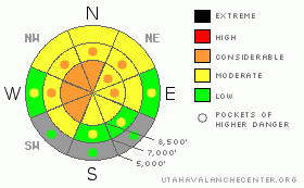
BOTTOM LINE
Danger by aspect and elevation on slopes approaching 35° or steeper.
(click HERE for tomorrow's danger rating)
|
Danger Rose Tutorial
|
There's a level 3 or Considerable danger on upper elevation slopes with recent deposits of drifted snow, where you are likely to trigger wind slabs or dangerous deep slab avalanches. There are also still many areas with pockets of level 3 or Considerable danger, and dangerous deep slab avalanche conditions persist on slopes with poor snow structure, especially on very steep upper and mid elevation slopes facing the northern half of the compass. Wind slab avalanches are likely on some recently drifted slopes, and drifting likely occurred in somewhat unusual areas. Careful snowpack evaluation, cautious route-finding, and conservative decision-making will again be essential in the backcountry today, and you should continue to avoid steep drifted slopes at upper and mid elevations. You'll find safer conditions in sheltered areas, on south facing slopes, and at lower elevations, and there's still lots of nice fast and fun snow in lower angled terrain. |
|
|
CURRENT CONDITIONS |

|
It's 17 degrees up at the 8400' Tony Grove Snotel this morning, and there is 71 inches of total snow on the ground containing 82% of normal water for the date. The CSI Logan Peak weather station at 9700' reports 10 degrees, with a significant increase in easterly winds overnight. Winds intensified in the early morning hours and averaged over 40 mph between 5:00 and 6:00 with a gust of 53 mph... Strong winds from the east-northeast will find plenty of soft snow to drift about, and we'll find wind slabs and stiff wind deposits in somewhat unusual places today.
You can still find plenty of enjoyable and fast shallow powder conditions, and lower angled slopes are both fun and much less dangerous than steeper terrain. We continue to find widespread poor snow structure, with a slab consisting of heavy strong snow sitting on top of very weak sugary faceted snow or depth hoar, which on most slopes in the Logan Area is elevated a foot or two off the ground and above the anchoring affects of shrubs and rocks. The probability of deadly deep slab avalanches is gradually diminishing, but the potential persists on many steep slopes in the zone, and the consequences of being caught are still quite severe. |
|
|
RECENT ACTIVITY |

|
No significant new avalanches were reported in the Logan Zone in over a week now, but reports of significant audible collapsing in the zone continue to trickle in.. Collapsing or whumphfing is a bad sign indicating lingering deep slab instability.... Bruce Tremper describes the deep slab problem in detail in this new video tutorial.
(go to our current conditions page for more details on local activity and reports of other recent avalanches in Utah) |
|
|
THREAT #1 |

|
| WHERE |
PROBABILITY |
SIZE |
TREND |

|
|
|
|
| |
|
|
Over the next
24 hours.
|
|
|
It is becoming less likely that you will trigger large deep slab avalanches, but the dragons are no less deadly if you do. Despite the gradual decline in the probability of triggering deep avalanches and a general increase in snowpack strength, there are still many slopes still with very poor snow structure, on which you might trigger very dangerous deep slab avalanches.
You could still trigger dangerous deep slab avalanches in steep terrain, especially on very steep recently drifted upper elevation slopes. In some cases, avalanches could still be very sensitive or easy to trigger, and you might trigger them remotely from a distance, or worse, from below. Other hard deep slabs might be much more stubborn and will take a larger trigger like a cornice fall or the weight of a sled or two to avalanche. Hard deep slabs are quite tricky and could allow you to get out on them before releasing, or they might wait and fail on the second or third or fourth time you climb a slope. Under these conditions obvious signs of instability may well be absent, but still pay close attention to red flags like collapsing and shooting cracks, and reevaluate you route if you encounter any red flags. Have patience and continue to avoid steep drifted slopes. |
|
|
THREAT #2 |

|
| WHERE |
PROBABILITY |
SIZE |
TREND |

|
|
|
|
| |
|
|
Over the next
12 hours.
|
|
|
With this morning's strong easterly winds, you should expect to find fresh drifts and wind slabs in somewhat unusual locations. Of particular concern are upper elevation west facing slopes, where drifting will add weight to slopes with weak structure that haven't yet seen much of a load this year. Wind slab avalanches are most likely on the lee sides of major ridge lines and in and around terrain features like sub-ridges, gullies, scoops, and cliff bands. Smaller or shallow wind slab avalanches overrunning a slope with poor snow structure could trigger much larger and more dangerous deep slab avalanches..... |
|
|
MOUNTAIN WEATHER |

|
It will be rather windy and cold today in the mountains, with an east wind, mostly cloudy skies and a lingering chance for a few snow flakes... Windy conditions will continue and even intensify tonight, with southeast winds and temperatures in the teens. Mostly sunny conditions will develop for the weekend and temperatures will gradually climb each day in the mountains. Looks like a strong high pressure system will slowly move in and control the weather well into next week, so we can expect fair and mild weather in the mountains and colder hazy and smoggy conditions to develop in the valleys.... |
|
|
GENERAL ANNOUNCEMENTS |
Please consider a donation to your favorite non-profit –The Friends of the Utah Avalanche Center. The Utah Avalanche Center depends on contributions from users like you to support our work.....
Please send us your observations from the backcountry especially if you see or trigger an avalanche, but also even if you don't.. go to avalanche and snow observations. You can also call me directly at 435-757-7578 or leave us a message at our office, 801-524-5304.... And, you can always send us a simple email by clicking HERE
I will update this advisory by around 7:30 in the morning on Mondays, Wednesdays, Fridays, and Saturdays.....
This advisory is from the U.S.D.A. Forest Service, which is solely responsible for its content. This advisory describes general avalanche conditions and local variations always occur. |
|
|
This information does not apply to developed ski areas or highways where avalanche control is normally done. This advisory is from the U.S.D.A. Forest Service, which is solely responsible for its content. This advisory describes general avalanche conditions and local variations always occur. |
|
This advisory provided by the USDA Forest Service, in partnership with:
The Friends of the Utah Avalanche Center, Utah Division of State Parks and Recreation, Utah Division of Emergency Management, Salt Lake County, Salt Lake Unified Fire Authority and the friends of the La Sal Avalanche Center. See our Sponsors Page for a complete list. |
