BOTTOM LINE
Danger by aspect and elevation on slopes approaching 35° or steeper.
(click HERE for tomorrow's danger rating)
|
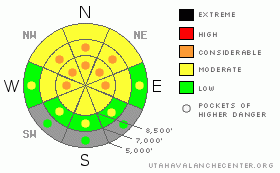
Danger Rose Tutorial
|
As the snowpack gradually stabilizes, the avalanche danger is slowly coming down. Heightened avalanche conditions still exist, with a level 2 or Moderate danger on many slopes in the backcountry where you might trigger dangerous avalanches . There are also still many areas with pockets of level 3 or Considerable danger, and dangerous deep slab avalanche conditions persist on slopes with poor snow structure. You could still trigger very dangerous, huge and perhaps deadly deep slab avalanches, most likely on very steep upper and mid elevation slopes facing the northern half of the compass. Wind slab avalanches are also possible on recently drifted slopes, and in some cases, a smaller avalanche overrunning a slope with poor snow structure could create a much bigger and more dangerous deep slab avalanche. Careful snowpack evaluation, cautious route-finding, and conservative decision-making will be essential in the backcountry today, and you should continue to avoid steep drifted slopes at upper and mid elevations. You'll find safer conditions in sheltered areas, on south facing slopes, and at lower elevations, and there's still lots of nice fast and fun snow in lower angled terrain. |
|
|
CURRENT CONDITIONS |

|
It's 22 degrees up at the 8400' Tony Grove Snotel this morning, and there is 72 inches of total snow on the ground containing 83% of normal water for the date. The CSI Logan Peak weather station at 9700' also reports 22 degrees, with 15 to 20 mph west and southwest winds this morning. You can find plenty of enjoyable and fast shallow powder conditions, and lower angled slopes are both fun and much less dangerous than steeper terrain. There's a variable rain-crust down low, and a supportable melt-freeze-crust on lots of sunny slopes. We continue to find widespread poor snow structure, with a slab consisting of heavy strong snow sitting on top of very weak sugary faceted snow or depth hoar, and although the danger is gradually diminishing, very dangerous deep slab avalanche potential persists on many steep slopes in the zone. |
|
|
RECENT ACTIVITY |

|
No significant new avalanches were reported in the Logan Zone from over the weekend, and it's been a week now since our most recent close call, when a group of riders watched from below as a large hard slab avalanche released above them in the Rodeo Grounds on the east side of Logan Peak.
(go to our current conditions page for more details on local activity and reports of other recent avalanches in Utah) |
|
|
THREAT #1 |

|
| WHERE |
PROBABILITY |
SIZE |
TREND |

|
|
|
|
| |
|
|
Over the next
24 hours.
|
|
|
Dangerous avalanche conditions persist on steep slopes in the backcountry. A good deal of stabilization has occurred during the week-and-a-half after our productive storms, but there are many slopes still with very poor snow structure, on which you might trigger very dangerous deep slab avalanches. The weakest snow is on slopes facing the northern half of the compass rose. We continue to get reports of booming audible collapses and shooting cracks in untraveled areas, which are signs of continued instability....
You could trigger large 4 to 6 foot deep slab avalanches in steep terrain, especially on recently drifted upper elevation slopes. In some cases, avalanches may be very sensitive or easy to trigger, and you might trigger them remotely from a distance, or worse, from below. Other deep slabs might be much more stubborn and take a large trigger like a cornice fall or the weight of a sled or two to avalanche. Hard slabs are quite tricky and could allow you to get out on them before releasing, or they might wait and fail on your second or third time to climb a slope. Pay close attention to red flags like collapsing and shooting cracks, and continue to avoid steep drifted slopes. |
|
|
THREAT #2 |

|
| WHERE |
PROBABILITY |
SIZE |
TREND |
|
|
|
|
| |
|
|
Over the next
12 hours.
|
|
|
Wind slab avalanches are most likely on the lee sides of major ridge lines and in and around terrain features like sub-ridges, gullies, scoops, and cliff bands. Smaller or shallow wind slab avalanches overrunning a slope with poor snow structure could trigger much larger and more dangerous deep slab avalanches..... |
|
|
MOUNTAIN WEATHER |

|
A weakening and splitting storm will bring a little snowfall to the zone today, and around an inch of accumulation is expected along with moderate southwest winds. High temperatures at 8500' are expected to reach around 33 degrees... We could pick up 2 to 4 inches of accumulation tonight, winds will shift around from the northwest, and a couple more inches are possible tomorrow and tomorrow night. Looks like a strong high pressure system will move in and control the weather for the coming weekend and well into next week, so we can expect fair and mild weather in the mountains and colder hazy and smoggy conditions to develop in the valleys.... |
|
|
GENERAL ANNOUNCEMENTS |
Please consider a donation to your favorite non-profit –The Friends of the Utah Avalanche Center. The Utah Avalanche Center depends on contributions from users like you to support our work.....
Please send us your observations from the backcountry especially if you see or trigger an avalanche, but also even if you don't.. go to avalanche and snow observations. You can also call me directly at 435-757-7578 or leave us a message at our office, 801-524-5304.... And, you can always send us a simple email by clicking HERE
I will update this advisory by around 7:30 in the morning on Mondays, Wednesdays, Fridays, and Saturdays.....
This advisory is from the U.S.D.A. Forest Service, which is solely responsible for its content. This advisory describes general avalanche conditions and local variations always occur. |
|
|
This information does not apply to developed ski areas or highways where avalanche control is normally done. This advisory is from the U.S.D.A. Forest Service, which is solely responsible for its content. This advisory describes general avalanche conditions and local variations always occur. |
|
This advisory provided by the USDA Forest Service, in partnership with:
The Friends of the Utah Avalanche Center, Utah Division of State Parks and Recreation, Utah Division of Emergency Management, Salt Lake County, Salt Lake Unified Fire Authority and the friends of the La Sal Avalanche Center. See our Sponsors Page for a complete list. |
