BOTTOM LINE
Danger by aspect and elevation on slopes approaching 35° or steeper.
(click HERE for tomorrow's danger rating)
|
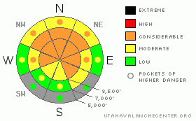
Danger Rose Tutorial
|
There is a level 3 or Considerable danger in the backcountry, and dangerous deep slab avalanche conditions persist, mainly at upper elevations and in drifted terrain. You could still trigger very dangerous, huge and perhaps deadly deep slab avalanches. Wind slab avalanches are also likely on recently drifted slopes, and a smaller avalanche overrunning a slope with poor snow structure could cause a step down and a much bigger and more dangerous deep slab avalanche. Keep in mind that most accidents and fatalities in Utah occur during periods with a level 3 danger. Careful snowpack evaluation, cautious route-finding, and conservative decision-making will be essential in the backcountry today, and you should continue to avoid steep drifted slopes at upper and mid elevations. You'll find safer conditions in sheltered areas, on south facing slopes, and at lower elevations, and nice fast and fun snow in lower angled terrain. |
|
|
CURRENT CONDITIONS |

|
You can find enjoyable and fast shallow powder conditions, and lower angled slopes are both fun and much less dangerous than steep terrain. There's a variable rain crust down low, and a supportable melt-freeze on lots of sunny slopes. We've been finding widespread poor snow structure, with a slab consisting of heavy strong snow sitting on top of very weak sugary faceted snow or depth hoar. It is no secret that very dangerous deep slab avalanche potential persists on many steep slopes in the zone. It's a balmy 28 degrees up at the 8400' Tony Grove Snotel this morning, and there is 72 inches of total snow on the ground. The CSI Logan Peak weather station at 9700' reports 20 degrees, with a consistent 30+ mph southwest wind and gusts to 46 mph this morning. |
|
|
RECENT ACTIVITY |

|
We've received reports of several more large triggered deep slabs in the mountains of Northern Utah from over the weekend. Tragically, a 24-year-old snowboarder was killed on Saturday after triggering a very large avalanche and being carried down more than 2000 vertical feet through rocky terrain and buried in Big Cottonwood Canyon near Salt Lake City... Yesterday a skier was caught and carried quite a ways by an avalanche he triggered after the party of two had already skied and climbed back out of the slope. The party's tracks disappearing into the fresh avalanche led to the unnecessary deployment of a rescue party. The message here is to report avalanches that you are involved in, even if you don't need help, so you don't put others at risk...
No significant new avalanches were reported in the Logan Zone from over the weekend, but there were three close calls involving large avalanches and riders last week.. (go to our current conditions page for more details on local activity and reports of other recent avalanches in Utah) |
|
|
THREAT #1 |

|
| WHERE |
PROBABILITY |
SIZE |
TREND |
|
|
|
|
| |
|
|
Over the next
24 hours.
|
|
|
Dangerous avalanche conditions persist on steep slopes in the backcountry. A good deal of stabilization has occurred during the week after our productive storms, but there are many slopes still with very poor snow structure, on which you could trigger very dangerous deep slab avalanches. We continue to get reports of booming audible collapses, sometimes accompanied by shooting cracks in the area, which are signs of continued instability....
You could trigger large 4 to 6 foot deep slab avalanches in steep terrain, especially on recently drifted upper elevation slopes. In some cases, avalanches may be very sensitive or easy to trigger, and you might trigger them remotely from a distance, or worse, from below. Other deep slabs might be much more stubborn and take a large trigger like a cornice fall or the weight of a sled or two to avalanche. Hard slabs are quite tricky and could allow you to get out on them before releasing, or they might wait and fail on your second or third time to climb a slope. Pay close attention to red flags like collapsing or whumphing and/or shooting cracks, and continue to avoid steep drifted slopes. |
|
|
THREAT #2 |

|
| WHERE |
PROBABILITY |
SIZE |
TREND |
|
|
|
|
| |
|
|
Over the next
12 hours.
|
|
|
Strong southwest winds overnight drifted snow into lee slope starting zones and created a renewed danger of wind slab avalanches in exposed terrain. Wind slab avalanches are most likely on the lee sides of major ridge lines and in and around terrain features like sub-ridges, gullies, scoops, and cliff bands. Smaller or shallow wind slab avalanches overrunning a slope with poor snow structure could trigger much larger and more dangerous deep slab avalanches..... |
|
|
MOUNTAIN WEATHER |

|
A weakening storm will bring a little snowfall to the zone today, and around an inch of accumulation is expected along with moderately strong westerly winds. High temperatures at 8500' are expected to reach around 29 degrees... A few more flakes are possible overnight, but not much in the way of accumulation is expected. The cloudy and mostly unproductive weather will continue through Wednesday night, with only minor accumulations. Looks like a high pressure system will control the weather later in the week and into the upcoming weekend.... |
|
|
GENERAL ANNOUNCEMENTS |
Please consider a donation to your favorite non-profit –The Friends of the Utah Avalanche Center. The Utah Avalanche Center depends on contributions from users like you to support our work.....
Please send us your observations from the backcountry especially if you see or trigger an avalanche, but also even if you don't.. go to avalanche and snow observations. You can also call me directly at 435-757-7578 or leave us a message at our office, 801-524-5304.... And, you can always send us a simple email by clicking HERE
I will update this advisory by around 7:30 in the morning on Mondays, Wednesdays, Fridays, and Saturdays.....
This advisory is from the U.S.D.A. Forest Service, which is solely responsible for its content. This advisory describes general avalanche conditions and local variations always occur. |
|
|
This information does not apply to developed ski areas or highways where avalanche control is normally done. This advisory is from the U.S.D.A. Forest Service, which is solely responsible for its content. This advisory describes general avalanche conditions and local variations always occur. |
|
This advisory provided by the USDA Forest Service, in partnership with:
The Friends of the Utah Avalanche Center, Utah Division of State Parks and Recreation, Utah Division of Emergency Management, Salt Lake County, Salt Lake Unified Fire Authority and the friends of the La Sal Avalanche Center. See our Sponsors Page for a complete list. |
