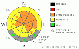
BOTTOM LINE
Danger by aspect and elevation on slopes approaching 35° or steeper.
(click HERE for tomorrow's danger rating)
|
Danger Rose Tutorial
|
There is a level 3 or Considerable danger in the backcountry, and dangerous deep slab avalanche conditions persist, mainly at upper elevations and on steep slopes with significant recent deposits of drifted snow. You could still trigger very dangerous, huge and perhaps deadly deep slab avalanches on many steep slopes. Keep in mind that most accidents and fatalities in Utah occur during periods with a level 3 danger, and weekends with nice weather top the list of most dangerous times. Careful snowpack evaluation, cautious route-finding, and conservative decision-making will be essential in the backcountry this weekend, and you should avoid steep drifted slopes at upper and mid elevations. You'll find safer conditions on south facing slopes, and at lower elevations, and pretty nice fast snow in sheltered areas and on lower angled terrain. |
|
|
CURRENT CONDITIONS |

|
It'll be a lovely day in the backcountry, with plenty of sunshine, good coverage and nice smooth, fast, and supportable shallow powder conditions... Certainly, the snow has become more stable since last weekend when a sudden addition of several feet of snow made things very active. But, very dangerous deep slab potential persists on many steep slopes in the zone. Weekends with nice weather, good snow, and dangerous avalanche conditions are a cause for serious concern. In many ways this is the most dangerous combination of conditions, because nice weather brings lots of people into the backcountry, and it has the tendency to make folks bold and more likely to make poor choices. Most accidents in the state occur during times with a level 3 danger.
It's 13 degrees up at the 8400' Tony Grove Snotel this morning, and there is 77 inches of total snow on the ground containing 87% of average water for the date. The CSI Logan Peak weather station at 9700' reports a chilly 4 degrees, with a consistent 20+ mph west wind this morning. |
|
|
RECENT ACTIVITY |

|
No significant new avalanches were reported in the Logan Zone from yesterday, but there were three close calls involving large avalanches in the last week.. Last weekend, a party of riders narrowly escaped a disaster when they triggered a good sized avalanche that ran between the well spread out party, but very close to one, and buried the Hillyard Canyon road between Cub River Canyon and Franklin Basin. On Tuesday, a couple riders triggered a 7' deep and 200' wide deep slab on Whiskey Hill in Monte Cristo. One rider was able to turn downhill and escape while the other rode off the top of the moving hard slab and crashed into the solid crown wall at the top of the avalanche inflicting substantial sled damage. Riders report a huge avalanche, 4 to 5 feet deep and 300-400 feet wide in the Rodeo Grounds in Upper Providence Canyon on Wednesday, which was witnessed by the group who were sitting in the flats below below when the slope released
(go to our current conditions page for more details on local activity and reports of other recent avalanches in Utah) |
|
|
THREAT #1 |

|
| WHERE |
PROBABILITY |
SIZE |
TREND |
|
|
|
|
| |
|
|
Over the next
24 hours.
|
|
|
Dangerous avalanche conditions still exist in many areas in the backcountry. The heavy snow from the productive storms last weekend overloaded widespread very weak sugary or faceted snow in many areas, and widespread large natural avalanches occurred across the zone. A good deal of stabilization occurred during the week, but there are many slopes still with very poor snow structure, on which you could trigger very dangerous deep slab avalanches. You are still likely to trigger large deep slab avalanches in very steep terrain, especially on recently drifted upper elevation slopes. You could trigger 4 to 6+ foot deep hard slab avalanches, which could also be very broad. In some cases avalanches may be very sensitive or easy to trigger, and you might trigger them remotely from a distance, or worse, from below. Other deep slabs might be much more stubborn and take a large trigger like a cornice fall or an air-bound sled to avalanche. These could allow you to get out on them before releasing, or they might wait and fail on the third or fourth or fifth person to cross the slope... Pay close attention to red flags like collapsing or whumphing and/or shooting cracks, and avoid steep drifted slopes. |
|
|
THREAT #2 |

|
| WHERE |
PROBABILITY |
SIZE |
TREND |
|
|
|
|
| |
|
|
Over the next
12 hours.
|
|
|
Strong west winds during Thursday's storm drifted fresh snow into lee slope starting zones and created a danger of softer wind slab avalanches in exposed terrain. Wind slab avalanches are most likely on the lee sides of major ridge lines and in and around terrain features like sub-ridges, gullies, scoops, and cliff bands. Smaller fresh wind slab avalanches overrunning a slope with poor snow structure could trigger much larger and more dangerous deep slab avalanches. |
|
|
MOUNTAIN WEATHER |

|
Expect chilly air temperatures and wind chills today, with 8000' highs in the lower twenties, moderate west winds and lots of sunshine. Tomorrow will be a bit warmer and we'll see a few clouds... A northwest flow will set up over the region early next week and several embedded ripples will bring periods of storminess and some snow to the mountains.. The first of these ripples will bring a chance for a few inches of accumulation Monday and Monday night.... |
|
|
GENERAL ANNOUNCEMENTS |
Please consider a donation to your favorite non-profit –The Friends of the Utah Avalanche Center. The Utah Avalanche Center depends on contributions from users like you to support our work.....
Please send us your observations from the backcountry especially if you see or trigger an avalanche, but also even if you don't.. go to avalanche and snow observations. You can also call me directly at 435-757-7578 or leave us a message at our office, 801-524-5304.... And, you can always send us a simple email by clicking HERE
I will update this advisory by around 7:30 in the morning on Mondays, Wednesdays, Fridays, and Saturdays.....
This advisory is from the U.S.D.A. Forest Service, which is solely responsible for its content. This advisory describes general avalanche conditions and local variations always occur. |
|
|
This information does not apply to developed ski areas or highways where avalanche control is normally done. This advisory is from the U.S.D.A. Forest Service, which is solely responsible for its content. This advisory describes general avalanche conditions and local variations always occur. |
|
This advisory provided by the USDA Forest Service, in partnership with:
The Friends of the Utah Avalanche Center, Utah Division of State Parks and Recreation, Utah Division of Emergency Management, Salt Lake County, Salt Lake Unified Fire Authority and the friends of the La Sal Avalanche Center. See our Sponsors Page for a complete list. |
