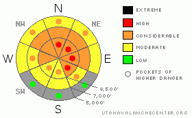
BOTTOM LINE
Danger by aspect and elevation on slopes approaching 35° or steeper.
(click HERE for tomorrow's danger rating)
|
Danger Rose Tutorial
|
There is a level 3 or Considerable danger in the backcountry, and dangerous deep slab avalanche conditions persist in steep upper and mid-elevation terrain. You'll find pockets with a level 4 or High danger at upper elevations on steep slopes with significant recent deposits of drifted fresh snow. You are still likely to trigger very dangerous and perhaps deadly deep slab avalanches on many steep slopes, and any triggered avalanche in drifted upper elevation terrain is likely to be huge and potentially unsurvivable. Careful snowpack evaluation, cautious route-finding, and conservative decision-making will be essential in the backcountry today, and you should avoid steep drifted slopes and obvious or historic avalanche paths.. You'll find safer conditions in lower angled terrain, on south facing slopes, and at lower elevations, but you could still trigger avalanches on steep slopes in most areas. |
|
|
CURRENT CONDITIONS |

|
It's 16 degrees up at the 8400' Tony Grove Snotel this morning, and there is 4 or 5 inches of heavy new snow containing 1.2" of water equivalent. There is 77 inches of total snow on the ground containing 88% of average water for the date. Seems like it rained for a while yesterday, at least at mid elevations. The CSI Logan Peak weather station at 9700' reports a chilly 6 degrees, and the wind sensor is reporting fairly light winds from the northwest. The Hwy 89 Logan Summit weather station reported much stronger northwest winds overnight, with 30 mph hourly averages and gusts well into the 40s. The winds appear to be subsiding a bit this morning and I'm reading about 20 mph from the west.... |
|
|
RECENT ACTIVITY |

|
No new avalanches were reported in the Logan Zone from yesterday, but there were a couple close calls earlier in the week. Last weekend, a party of sledders narrowly escaped a disaster when they triggered a good sized avalanche that ran between the well spread out party, but very close to one, and buried the Hillyard Canyon road between Cub River Canyon and Franklin Basin. On Tuesday, a couple riders triggered a 7' deep and 200' wide deep slab on Whiskey Hill in Monte Cristo. One rider was able to turn downhill and escape while the other rode off the top of the moving hard slab and crashed into the solid crown wall at the top of the avalanche inflicting substantial sled damage. And, a likely rider triggered avalanche from Wednesday was reported from the Rodeo Grounds in upper Providence Canyon, but I have few details....
(go to our current conditions page for more details on local activity and reports of other recent avalanches in Utah) |
|
|
THREAT #1 |

|
| WHERE |
PROBABILITY |
SIZE |
TREND |
|
|
|
|
| |
|
|
Over the next
24 hours.
|
|
|
Dangerous avalanche conditions still exist in many areas in the backcountry. The heavy snow from the productive storms late last week and over the weekend overloaded widespread very weak sugary or faceted snow in many areas, and widespread large natural avalanches occurred across the zone. Colder temperatures and a break in the snowfall allowed for some stabilization to occur during the week, but additional weight from several inches of heavy snow and wind loading yesterday could be enough to reactivate the slab.
You are still likely to trigger large deep slab avalanches in steep terrain, especially on recently drifted upper and mid elevation slopes. You could trigger 3 to 6 foot deep hard slab avalanches, which could also be very broad. In some cases avalanches may be very sensitive or easy to trigger, and you might trigger them remotely from a distance, or worse, from below. Harder deep slabs might be much more stubborn and could allow you to get out on them before releasing or they might wait and fail on the third or fourth or fifth person to cross the slope... Pay close attention to red flags like collapsing or whumphing and/or shooting cracks, and avoid steep drifted slopes. |
|
|
THREAT #2 |

|
| WHERE |
PROBABILITY |
SIZE |
TREND |
|
|
|
|
| |
|
|
Over the next
12 hours.
|
|
|
Strong west winds yesterday and from the northwest overnight drifted yesterday's fresh snow into lee slope starting zones and created a danger of softer wind slab avalanches in exposed terrain. Wind slab avalanches are most likely on the lee sides of major ridge lines and in and around terrain features like sub-ridges, gullies, scoops, and cliff bands. Smaller fresh wind slab avalanches overrunning a slope with poor snow structure could trigger much larger and more dangerous deep slab avalanches. |
|
|
MOUNTAIN WEATHER |

|
Looks like fair weather for the weekend, but remember that just because the weather is nice and you can see for once, dangerous avalanche conditions persist in the backcountry. This is a dangerous combination of conditions, and most accidents in the state occur during times with a level 3 danger. Weekends with nice weather, good snow, and dangerous avalanche conditions are a cause for concern. Please keep you senses out there folks, this is the time to use your head.
Expect cold air temperatures and wind chills today, with 8000' highs in the teens. Temperatures will gradually rise through the weekend and the weather will be mostly fair, with fairly light winds and lots of sunshine. A northwest flow will set up over the region early next week and several embedded ripples will bring periods of storminess and some snow to the mountains... |
|
|
GENERAL ANNOUNCEMENTS |
Please consider a donation to your favorite non-profit –The Friends of the Utah Avalanche Center. The Utah Avalanche Center depends on contributions from users like you to support our work.....
Please send us your observations from the backcountry especially if you see or trigger an avalanche, but also even if you don't.. go to avalanche and snow observations. You can also call me directly at 435-757-7578 or leave us a message at our office, 801-524-5304.... And, you can always send us a simple email by clicking HERE
I will update this advisory by around 7:30 in the morning on Mondays, Wednesdays, Fridays, and Saturdays.....
This advisory is from the U.S.D.A. Forest Service, which is solely responsible for its content. This advisory describes general avalanche conditions and local variations always occur. |
|
|
This information does not apply to developed ski areas or highways where avalanche control is normally done. This advisory is from the U.S.D.A. Forest Service, which is solely responsible for its content. This advisory describes general avalanche conditions and local variations always occur. |
|
This advisory provided by the USDA Forest Service, in partnership with:
The Friends of the Utah Avalanche Center, Utah Division of State Parks and Recreation, Utah Division of Emergency Management, Salt Lake County, Salt Lake Unified Fire Authority and the friends of the La Sal Avalanche Center. See our Sponsors Page for a complete list. |
