SPECIAL ANNOUNCEMENT |
 |
Come join local avalanche forecaster Toby Weed for a one evening, one field day avalanche awareness class specifically for snowmobilers. The class will cover avalanche rescue skills, terrain analysis, danger rating interpretation, safe travel techniques, as well as the basics of avalanche awareness. Thursday evening (1-26) will be a 2 hour classroom session. Saturday (1-28) will be a field day in the Tony Grove area. Please call 757-2794 for more info or to register please visit the education link on our website.... |
|
|
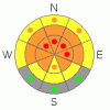
BOTTOM LINE
Danger by aspect and elevation on slopes approaching 35° or steeper.
(click HERE for tomorrow's danger rating)
|
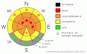
Danger Rose Tutorial
|
There is a level 3 or Considerable danger in the backcountry, and dangerous avalanche conditions persist in steep upper and mid-elevation terrain. Conditions have stabilized a bit since the active weekend, but you are still likely to trigger very dangerous and perhaps deadly, large hard persistent slab avalanches on many steep slopes. I've included a few pockets with a level 4 or High danger, since any triggered avalanche in drifted upper elevation terrain is likely to be huge and potentially unsurvivable. Careful snowpack evaluation, cautious route-finding, and conservative decision-making will be essential in the backcountry today, and you should continue to avoid steep slopes and obvious or historic avalanche paths.. You'll find safer conditions in lower angled terrain, on south facing slopes, and at lower elevations, but triggered avalanches are still possible in most areas. |
|
|
CURRENT CONDITIONS |

|
You can find nice smooth and fast, shallow powder conditions on gentle slopes in the backcountry, and there's no need the play in the much more dangerous steep terrain. The mountains around Logan picked up a few feet of snow late last week and over the weekend. The heavy wet snow from Thursday has set up and riding conditions are good, with fairly supportable although deep snow, and one can certainly get around on a sled... You can also easily get bogged down and badly stuck especially in drifted areas, and we spent a good part of our day on Monday digging out the Nitro...
It's 26 degrees up at the 8400' Tony Grove Snotel this morning, and there is 75 inches of total snow on the ground containing 84% of average water for the date. The station picked up an amazing 8 inches of water between 18th and the 21st. The CSI Logan Peak weather station at 9700' reports 21 degrees and overnight west winds averaging around 25 mph for a few hours... |
|
|
RECENT ACTIVITY |

|
A couple large and extensive natural avalanche cycles occurred in the Logan Area Thursday and Saturday nights, and there were hundreds of large avalanches on steep slopes across the zone and the mountains of Northern Utah. Several avalanches locally were triggered in terrain where avalanches are not all that common and on fairly low angled slopes, and thankfully no one was caught.... While many many slopes avalanched already in the last couple days, many did not, and slide paths that ran on Thursday night are completely filled in again and suspect.... No new avalanches were reported in the Logan Zone since the active weekend..
(go to our current conditions page for more details on local activity and reports of other recent avalanches in Utah) |
|
|
THREAT #1 |

|
| WHERE |
PROBABILITY |
SIZE |
TREND |
|
|
|
|
| |
|
|
Over the next
48 hours.
|
|
|
Late last week and over the weekend heavy snow overloaded widespread very weak sugary or faceted snow in many areas, and large and destructive natural avalanches occurred across the zone. Colder temperatures and a break in the snowfall allowed for some stabilization to occur in the last couple days, but dangerous avalanche conditions still exist in many areas in the backcountry.
You are still likely to trigger large persistent slab avalanches in steep terrain, especially on recently drifted upper and mid elevation slopes. Triggered avalanches are most likely on the lee sides of major ridge lines and in and around terrain features like sub-ridges, gullies, scoops, and cliff bands. Avalanches in some areas with recent drifting are likely to be in the 4 to 6-feet-deep range and could be very broad. In some cases avalanches may be very sensitive or easy to trigger, and you might trigger them remotely from a distance, or worse, from below. Harder deep slabs might be much more stubborn and could allow you to get out on them before releasing or they might wait and fail on the third or fourth or fifth person to cross the slope... Pay close attention to red flags like collapsing or whumphing and/or shooting cracks, and be willing to reevaluate or change your plans... |
|
|
MOUNTAIN WEATHER |

|
We'll see mostly cloudy, mild, and breezy weather in the mountains today, with 8500' high temperatures around 34 degrees and west winds averaging in the mid-twenties. We should see a few snowflakes, but not much is expected in the way of accumulation. Temperatures will drop a few degrees below freezing overnight and winds will diminish a bit, but it will be cloudy and an inch of accumulation is forecast. The mild and moist westerly or zonal flow kicks in tomorrow and significant accumulations of heavy snow and fairly strong west winds are forecast. Storminess should continue into tomorrow night and 1 to 2 feet of heavy snow is likely at upper elevations by Friday morning. The additional accumulations and drifting will probably cause the danger to rise back up to High or level 4 tomorrow, and despite a generally fair weather forecast, dangerous avalanche conditions are likely to persist through the coming weekend..... |
|
|
GENERAL ANNOUNCEMENTS |
Please consider a donation to your favorite non-profit –The Friends of the Utah Avalanche Center. The Utah Avalanche Center depends on contributions from users like you to support our work.....
Please send us your observations from the backcountry especially if you see or trigger an avalanche, but also even if you don't.. go to avalanche and snow observations. You can also call me directly at 435-757-7578 or leave us a message at our office, 801-524-5304.... And, you can always send us a simple email by clicking HERE
I will update this advisory by around 7:30 in the morning on Mondays, Wednesdays, Fridays, and Saturdays.....
This advisory is from the U.S.D.A. Forest Service, which is solely responsible for its content. This advisory describes general avalanche conditions and local variations always occur. |
|
|
This information does not apply to developed ski areas or highways where avalanche control is normally done. This advisory is from the U.S.D.A. Forest Service, which is solely responsible for its content. This advisory describes general avalanche conditions and local variations always occur. |
|
This advisory provided by the USDA Forest Service, in partnership with:
The Friends of the Utah Avalanche Center, Utah Division of State Parks and Recreation, Utah Division of Emergency Management, Salt Lake County, Salt Lake Unified Fire Authority and the friends of the La Sal Avalanche Center. See our Sponsors Page for a complete list. |
