AVALANCHE WARNING »
Dangerous avalanche conditions are occuring or are imminent.
Backcountry travel in avalanche terrain is not recommended.
|
 |
Notice: The avalanche warning continues for all the mountains of northern Utah. Deadly human triggered avalanches continue to be very likely on steeper slopes. Avalanches can be triggered from a distance, so stay out from underneath steep slopes as well. People without expert level avalanche skills are urged to stay out of the backcountry.

|
|
|
SPECIAL ANNOUNCEMENT |
 |
Come join local avalanche forecaster Toby Weed for a one evening, one field day avalanche awareness class specifically for snowmobilers. The class will cover avalanche rescue skills, terrain analysis, danger rating interpretation, safe travel techniques, as well as the basics of avalanche awareness. Thursday evening (1-26) will be a 2 hour classroom session. Saturday (1-28) will be a field day in the Tony Grove area. Please call 757-2794 for more info or to register please visit the education link on our website....
|
|
|
BOTTOM LINE
Danger by aspect and elevation on slopes approaching 35° or steeper.
(click HERE for tomorrow's danger rating)
|
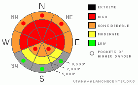
Danger Rose Tutorial
|
Three or four feet of very heavy new snow since Wednesday morning, containing up to 8 inches of water, fell on very weak preexisting snow accompanied by sustained westerly winds. The heavy snowfall and strong winds created a lingering level 4 or High danger on upper and mid elevation slopes in the backcountry. Very dangerous avalanche conditions exist across the zone, and large potentially deadly triggered persistent slab avalanches remain likely on steep slopes. You should continue to avoid travel in backcountry avalanche terrain, and stay off of and out from under all steep slopes, especially obvious or historic avalanche paths that haven't already avalanched recently ... |
|
|
CURRENT CONDITIONS |

|
With several feet of new snow and strong westerly winds late last week and over the weekend, the fragile preexisting snow was overloaded to the point of failure, and many large natural avalanches occurred in the mountains around Logan. I do not expect natural avalanches today, but the snow is still quite sensitive as evidenced by numerous collapses and extensive cracking in lower angle terrain. It is still very likely that you would trigger large avalanches if you were to venture onto steep slopes that didn't already avalanche. You should continue to avoid backcountry avalanche terrain for a while.
It's 19 degrees up at the 8400' Tony Grove Snotel this morning, and there is 77 inches of total snow on the ground containing 85% of average water for the date. The station picked up an amazing 8 inches of water between Wednesday the 18th and Saturday evening, the 21st. The CSI Logan Peak weather station at 9700' reports 14 degrees and south winds averaging around 17 mph... |
|
|
RECENT ACTIVITY |

|
A couple large and extensive natural avalanche cycles occurred in the Logan Area Thursday and Saturday nights, and there were hundreds of large avalanches on steep slopes across the zone and the mountains of Northern Utah. Several avalanches locally were triggered in terrain where avalanches are not all that common and on fairly low angled slopes, and thankfully no one was caught.... While many many slopes avalanched already in the last couple days, many did not. Many of these sit in a delicate balance just waiting for someone to come along and be a trigger.
(go to our current conditions page for more details on local activity and reports of other recent avalanches in Utah) |
|
|
THREAT #1 |

|
| WHERE |
PROBABILITY |
SIZE |
TREND |
|
|
|
|
| |
|
|
Over the next
24 hours.
|
|
|
Heavy new snow overloaded widespread very weak sugary or faceted snow in many areas, and large and destructive natural avalanches occurred across the zone. Mid elevation slopes were still quite sensitive and reactive to human weight yesterday, and the thicker snow at upper elevations may be a bit more stubborn, which could allow folks to get out on slopes before failing.
You are likely to trigger large persistent slab avalanches on the lee side of major ridge lines and in and around terrain features like sub-ridges, gullies, scoops, and cliff bands. Hard or soft slab avalanches running on weak and sugary faceted snow could now be two to four feet deep. Avalanches in some areas with recent drifting might be more in the 4 to 6 feet deep range and very broad. In many cases avalanches are likely to be very sensitive or easy to trigger, and you might trigger them remotely from a distance, or worse, from below. Harder slabs might be much more stubborn and could allow you to get out on them before releasing or they might wait and fail on the third or fourth or fifth person to cross the slope... |
|
|
MOUNTAIN WEATHER |

|
The next splitting Pacific storm will impact the region today and tonight, and 4 to 8 inches of accumulation is possible in our area with more stormy conditions expected well to our south. Expect moderate south-southwest winds and high temperatures around 24 degrees today, dropping into the teens tonight. A mild westerly flow will set up over the region, bringing increasing chances for snow to the Logan Zone later on in the week... Another cold front (storm) is expected near the end of the work week but models diverge on it's potency... |
|
|
GENERAL ANNOUNCEMENTS |
Please consider a donation to your favorite non-profit –The Friends of the Utah Avalanche Center. The Utah Avalanche Center depends on contributions from users like you to support our work.....
Please send us your observations from the backcountry especially if you see or trigger an avalanche, but also even if you don't.. go to avalanche and snow observations. You can also call me directly at 435-757-7578 or leave us a message at our office, 801-524-5304.... And, you can always send us a simple email by clicking HERE
I will update this advisory by around 7:30 in the morning on Mondays, Wednesdays, Fridays, and Saturdays.....
This advisory is from the U.S.D.A. Forest Service, which is solely responsible for its content. This advisory describes general avalanche conditions and local variations always occur. |
|
|
This information does not apply to developed ski areas or highways where avalanche control is normally done. This advisory is from the U.S.D.A. Forest Service, which is solely responsible for its content. This advisory describes general avalanche conditions and local variations always occur. |
|
This advisory provided by the USDA Forest Service, in partnership with:
The Friends of the Utah Avalanche Center, Utah Division of State Parks and Recreation, Utah Division of Emergency Management, Salt Lake County, Salt Lake Unified Fire Authority and the friends of the La Sal Avalanche Center. See our Sponsors Page for a complete list. |
