AVALANCHE WARNING »
Dangerous avalanche conditions are occuring or are imminent.
Backcountry travel in avalanche terrain is not recommended.
|
 |
Notice: THE AVALANCHE WARNING CONTINUES THROUGH THE WEEKEND FOR ALL THE MOUNTAINS OF NORTHERN UTAH. THIS INCLUDES THE BEAR RIVER RANGE, THE WESTERN UINTAS AND THE WASATCH PLATEAU. HEAVY SNOW AND STRONG WINDS HAVE EASILY OVERLOADED A WEAK AND FRAGILE PRE-EXISTING SNOWPACK RESULTING IN EXTREMELY DANGEROUS AVALANCHE CONDITIONS. BACKCOUNTRY TRAVEL IS NOT RECOMMENDED. |
|
|
BOTTOM LINE
Danger by aspect and elevation on slopes approaching 35° or steeper.
(click HERE for tomorrow's danger rating)
|
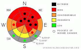
Danger Rose Tutorial
|
Heavy snowfall on very weak preexisting snow, sustained westerly winds, and much milder temperatures created a level 4 or High danger on upper and mid elevation slopes in the backcountry. I've included pockets of level 5 in my danger rose because additional heavy snowfall and strong south and west winds will continue to overload the already heavily taxed snowpack and the danger will probably rise to Extreme on slopes that haven't already avalanched... This is our highest danger rating, and we do not use it often. Very dangerous avalanche conditions exist across the zone, and large destructive natural and triggered persistent slab avalanches remain likely on steep slopes. You should avoid travel in backcountry avalanche terrain this weekend. Stay off of and out from under all steep slopes, especially obvious or historic avalanche paths... |
|
|
CURRENT CONDITIONS |

|
It's 32 degrees up at the 8400' Tony Grove Snotel this morning, and the station reports 1 or 2 inches from overnight with 3/10ths of an inch of water. There is 67 inches of total snow on the ground containing 78% of average water for the date. The CSI Logan Peak weather station at 9700' reports 27 degrees and south winds overnight pushing 40 mph hourly averages with gusts over 60 mph early this morning... The fragile preexisting snow was overloaded to the point of failure, and many large natural avalanches occurred in the last 36 hours. large natural avalanches are again likely today as significant additional snow and strong winds are forecast. You should continue to avoid backcountry avalanche terrain this weekend.... |
|
|
RECENT ACTIVITY |

|
We've received reports of numerous large natural and triggered avalanches yesterday from across the mountains of Northern Utah.... Several of these avalanches were in the 1/2mile wide range, with 2' the average depth. Locally, skiers triggered several rare avalanches on the backside of Beaver Mountain and no one was caught. An extensive natural cycle occurred in the Bear River Range overnight Thursday night. I rode up to Tony Grove yesterday afternoon and observed evidence of widespread natural avalanches on most steep slopes facing north, northeast, and east above around 7000' in elevation. Observers report natural avalanches on more westerly facing slopes visible from Cache Valley in Logan Dry Canyon and the Mount Naomi Wilderness. Problem is that many slopes in the region didn't avalanche yet and are probably hanging in delicate balance.
(go to our current conditions page for more details and reports of other recent activity in Utah) |
|
|
THREAT #1 |

|
| WHERE |
PROBABILITY |
SIZE |
TREND |
|
|
|
|
| |
|
|
Over the next
24 hours.
|
|
|
Heavy new snow overloaded widespread very weak sugary or faceted snow in many areas, and large and destructive natural avalanches are occurring and remain likely on many slopes that haven't yet avalanched during the storm. Mid elevation slopes were quite sensitive and reactive to human weight yesterday, and additional loading from today's storm will likely push many slopes over the edge....
You are likely to trigger large persistent wind slab avalanches on the lee side of major ridge lines and in and around terrain features like sub-ridges, gullies, scoops, and cliff bands. Hard or soft slab avalanches running on weak and sugary faceted snow could now be two to four feet deep. Avalanches in some areas with recent drifting might be very sensitive or easy to trigger, and you might trigger them remotely from a distance, or worse, from below. Harder wind slabs might be much more stubborn and could allow you to get out on them before releasing.. Wind slab avalanches could trigger broader avalanches as they overrun lower slopes and they may sweep out and entrain significant quantities of weak sugary underlying old snow. |
|
|
THREAT #3 |
|
No problem identified.
|
| WHERE |
PROBABILITY |
SIZE |
TREND |

|
| No probability identified. |
|
|
|
|
|
Rain saturated the shallow snow at lower elevations and triggered wet avalanches are likely on steep slopes with wet snow.... I noticed several wet avalanches Thursday in shady terrain coming down into the Logan River below Temple Fork. Warm temperatures this morning will gradually cool throughout today. The cooling will freeze up the saturated snow and the danger of wet avalanches will diminish... |
|
|
MOUNTAIN WEATHER |

|
Expect additional heavy snowfall and strong southwest winds today, with around a foot of heavy snow forecast to accumulate by this evening. Several more inches are likely tonight with temperatures dropping into the teens. It'll be much colder tomorrow and we'll get a bit of a break in the weather. More snow is likely tomorrow night..... |
|
|
GENERAL ANNOUNCEMENTS |
Please consider a donation to your favorite non-profit –The Friends of the Utah Avalanche Center. The Utah Avalanche Center depends on contributions from users like you to support our work.....
Please send us your observations from the backcountry especially if you see or trigger an avalanche, but also even if you don't.. go to avalanche and snow observations. You can also call me directly at 435-757-7578 or leave us a message at our office, 801-524-5304.... And, you can always send us a simple email by clicking HERE
I will update this advisory by around 7:30 in the morning on Mondays, Wednesdays, Fridays, and Saturdays.....
This advisory is from the U.S.D.A. Forest Service, which is solely responsible for its content. This advisory describes general avalanche conditions and local variations always occur. |
|
|
This information does not apply to developed ski areas or highways where avalanche control is normally done. This advisory is from the U.S.D.A. Forest Service, which is solely responsible for its content. This advisory describes general avalanche conditions and local variations always occur. |
|
This advisory provided by the USDA Forest Service, in partnership with:
The Friends of the Utah Avalanche Center, Utah Division of State Parks and Recreation, Utah Division of Emergency Management, Salt Lake County, Salt Lake Unified Fire Authority and the friends of the La Sal Avalanche Center. See our Sponsors Page for a complete list. |
