AVALANCHE WARNING »
Dangerous avalanche conditions are occuring or are imminent.
Backcountry travel in avalanche terrain is not recommended.
|
 |
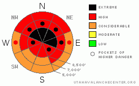
Notice: The AVALANCHE WARNING continues for the mountains near Salt Lake, Provo, Ogden, Logan and the Western Uintas. A High avalanche danger exists for the Wasatch Range and the Uinta Mountains with an Extreme danger in the Logan and northern Ogden area mountains. Heavy, dense snow with wind has overloaded an extremely weak pre-exisiting snowpack. Many natural and human triggered avalanches have occurred and may continue today. People should stay off of, and out from underneath, any steep slope. Only those with excellent avalanche training and experience should attempt backcountry travel.
|
|
|
BOTTOM LINE
Danger by aspect and elevation on slopes approaching 35° or steeper.
(click HERE for tomorrow's danger rating)
|
Danger Rose Tutorial
|
Heavy snowfall on very weak preexisting snow, sustained westerly winds, and much milder temperatures created a level 5 or Extreme danger on upper and mid elevation slopes in the backcountry. This is our highest danger rating, and we do not use it often. Very dangerous avalanche conditions exist across the zone, and large destructive natural and triggered persistent slab avalanches are likely on steep slopes that haven't yet avalanched with the storm yesterday or overnight. Wind slab avalanches are also very likely in drifted terrain, and wet avalanches are probable at lower elevations. You should avoid travel in backcountry avalanche terrain this weekend. Stay off of and out from under all steep slopes, especially obvious or historic avalanche paths... |
|
|
CURRENT CONDITIONS |

|
We simply got too much snow, and the fragile shallow snowpack is overwhelmed. Very dangerous avalanche conditions exist in the backcountry, and you should stay out of avalanche prone terrain today. The Tony Grove Snotel reports 33 inches of very heavy, settled out new snow containing a whopping 6 inches of water in the last 48 hrs. It's a balmy 28 degrees, and there is now 65 inches of total snow on the ground containing 73% of average water for the date. Westerly winds sustained hourly average wind speeds in excess of 20 mph, with gusts in the 40s overnight at the Highway 89 Logan Summit weather station. The wind sensor at the CSI Logan Peak weather station appears rimed still this morning, and it's 22 degrees at 9700' atop Logan Peak. |
|
|
RECENT ACTIVITY |

|
We've received reports of numerous large natural and triggered avalanches yesterday from across the mountains of Northern Utah.... Apparently the clouds opened up for a time to our south allowing for many of these to be viewed. Not so in the mountains around Logan, which remained socked-in with visibility of the mountains obscured all day yesterday. Even so, I noticed several wet avalanches and a nice natural persistent slab release at lower elevations in Logan Canyon on my way down from Beaver Mountain yesterday afternoon.. Given the ridiculously large amount of water weight added to the fragile snowback, I'm certain that many large natural avalanches occurred yesterday and overnight, and I'm hopping to get views and reports today....
On Wednesday, before the storm even really began, I triggered a sizable wind slab from a flat ridgetop. Cracks propagated from my skis on the ridge down into the slope below as the slab failed. The very sensitive or easy to trigger avalanche at 8900' on a mostly east facing slope was 1 to 1.5 feet deep, around 75 feet wide and it ran about 500 vertical feet. Even though this avalanche wasn't all that big it entrained a good deal of sugary or faceted snow, ran fast and far, and would have been very dangerous or even deadly if you got caught in it.
(go to our current conditions page for more details and reports of other recent activity in Utah) |
|
|
THREAT #1 |

|
| WHERE |
PROBABILITY |
SIZE |
TREND |

|
|
|
|
| |
|
|
Over the next
24 hours.
|
|
|
Heavy new snow overloaded widespread very weak sugary or faceted snow in many areas, and large and destructive natural avalanches are occurring and remain likely on many slopes that haven't yet avalanched during the storm. |
|
|
THREAT #2 |

|
| WHERE |
PROBABILITY |
SIZE |
TREND |
|
|
|
|
| |
|
|
Over the next
24 hours.
|
|
|
You are likely to trigger large wind slab avalanches on the lee side of major ridge lines and in and around terrain features like sub-ridges, gullies, scoops and cliff bands. Hard or soft wind slab avalanches running on weak and sugary faceted snow could now be two to six feet deep. Avalanches in some areas with recent drifting might be very sensitive or easy to trigger, and you might trigger them remotely from a distance, or worse, from below. Harder wind slabs might be much more stubborn and could allow you to get out on them before releasing.. Wind slab avalanches could trigger broader avalanches as they overrun lower slopes and they may sweep out and entrain significant quantities of weak sugary underlying old snow. |
|
|
THREAT #3 |

|
| WHERE |
PROBABILITY |
SIZE |
TREND |
|
|
|
|
| |
|
|
Over the next
24 hours.
|
|
|
Rain saturated the shallow snow at lower elevations and triggered wet avalanches are likely on steep slopes with saturated snow.... I noticed several wet avalanches yesterday in shady terrain coming down into the Logan River below Temple Fork. |
|
|
MOUNTAIN WEATHER |

|
The storm will ease a bit today, and we'll see a short lived break before a well organized cold front drops into the entire state on Saturday, and snowfall and winds will resume in the mountains, with another couple feet of accumulation possible Saturday and Saturday night.. Expect mild temperatures again today, with 8000' high temperatures approaching 30 degrees. An additional inch or two may fall and moderate westerly winds will continue... Snowfall will begin in earnest again tonight, with increasing southwest winds and 3 to 7 inches of accumulation forecast. It will be stormy again tomorrow, with very strong westerly winds again and 10 to 16 additional inches of accumulation forecast.... We might get another short break in the weather on Sunday. |
|
|
GENERAL ANNOUNCEMENTS |
Please consider a donation to your favorite non-profit –The Friends of the Utah Avalanche Center. The Utah Avalanche Center depends on contributions from users like you to support our work.....
Please send us your observations from the backcountry especially if you see or trigger an avalanche, but also even if you don't.. go to avalanche and snow observations. You can also call me directly at 435-757-7578 or leave us a message at our office, 801-524-5304.... And, you can always send us a simple email by clicking HERE
I will update this advisory by around 7:30 in the morning on Mondays, Wednesdays, Fridays, and Saturdays.....
This advisory is from the U.S.D.A. Forest Service, which is solely responsible for its content. This advisory describes general avalanche conditions and local variations always occur. |
|
|
This information does not apply to developed ski areas or highways where avalanche control is normally done. This advisory is from the U.S.D.A. Forest Service, which is solely responsible for its content. This advisory describes general avalanche conditions and local variations always occur. |
|
This advisory provided by the USDA Forest Service, in partnership with:
The Friends of the Utah Avalanche Center, Utah Division of State Parks and Recreation, Utah Division of Emergency Management, Salt Lake County, Salt Lake Unified Fire Authority and the friends of the La Sal Avalanche Center. See our Sponsors Page for a complete list. |
