AVALANCHE WARNING »
Dangerous avalanche conditions are occuring or are imminent.
Backcountry travel in avalanche terrain is not recommended.
|
 |
Notice: An AVALANCHE WARNING continues for the mountains near Salt Lake, Provo, Ogden, Logan and the Western Uintas. Weak snow from November and December is getting overloaded with heavy new snow. Natural avalanches are expected and human triggered avalanches are certain. People should avoid all steep slopes which includes being below any steep slope. Backcountry travel is not recommended. |
|
|
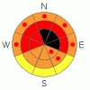
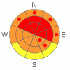
BOTTOM LINE
Danger by aspect and elevation on slopes approaching 35° or steeper.
(click HERE for tomorrow's danger rating)
|
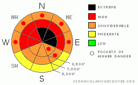
Danger Rose Tutorial
|
Heavy snowfall, sustained southwest winds, and milder temperatures created a level 4 or High danger in the backcountry, and the continuing storm will cause the avalanche danger to rise further and become more widespread throughout today. Very dangerous avalanche conditions already exist this morning, and large natural and triggered avalanches are likely in many areas. I've included a few areas with a level 5 or Extreme danger, our highest level, because forecast significant additional accumulating snow and continuing strong southwest wind will certainly cause large and destructive natural avalanches in some areas.... You should avoid all travel in backcountry avalanche terrain. Stay off of and out from under all steep slopes, especially obvious or historic avalanche paths... |
|
|
CURRENT CONDITIONS |

|
Expect increasing potential for large and destructive natural avalanches in the backcountry today. The Tony Grove Snotel reports 14 inches of very heavy settled new snow containing 2.7 inches of water in the last 24 hrs. It's a balmy 29 degrees, and there is now 48 inches of total snow on the ground containing 57% of average water for the date. Southwest winds sustained hourly average wind speeds in excess of 30 mph, with gusts in the 50s for the last couple days. The wind sensor at the CSI Logan Peak weather station appears rimed this morning, and it's 23 degrees at 9700' atop Logan Peak. |
|
|
RECENT ACTIVITY |

|
I triggered a sizable wind slab from a flat ridgetop. Cracks propagated from my skis on the ridge down into the avalanche as the slab failed. The very sensitive or easy to trigger avalanche at 8900' on a mostly east facing slope was 1 to 1.5 feet deep, around 75 feet wide and it ran about 500 vertical feet. Even though this avalanche wasn't all that big it entrained a good deal of sugary or faceted snow, ran fast and far, and would have been very dangerous or even deadly if you got caught in it.
(go to our current conditions page for more details and reports of other recent activity in Utah) |
|
|
THREAT #1 |

|
| WHERE |
PROBABILITY |
SIZE |
TREND |
|
|
|
|
| |
|
|
Over the next
24 hours.
|
|
|
Heavy new snow is overloading widespread very weak sugary or faceted snow in many areas, and large and destructive natural avalanches are likely and will almost certainly occur in some areas.. Heavy snowfall, strong winds, and rather mild temperatures in the mountains will continue through today and tonight and into tomorrow, overloading slopes with very poor existing snow structure. With this, the avalanche danger will continue to rise and become more widespread.... |
|
|
THREAT #2 |

|
| WHERE |
PROBABILITY |
SIZE |
TREND |
|
|
|
|
| |
|
|
Over the next
12 hours.
|
|
|
You are likely to trigger large wind slab avalanches on the lee side of major ridge lines and in and around terrain features like sub-ridges, gullies, scoops and cliff bands. Hard or soft wind slab avalanches running on weak and sugary faceted snow could be two to four feet deep. Avalanches in some areas with recent drifting might be very sensitive or easy to trigger, and you might trigger them remotely from a distance, or worse, from below. Harder wind slabs might be much more stubborn and could allow you to get out on them before releasing.. Wind slab avalanches could trigger broader avalanches as they overrun lower slopes and they may sweep out and entrain significant quantities of weak sugary underlying old snow. |
|
|
MOUNTAIN WEATHER |

|
Expect the potential for substantial snowfall in the mountains of Far Northern Utah to continue through today, tonight, and tomorrow under an increasingly wet, warm, and windy zonal or westerly flow.. An additional 4 to 8 inches of accumulation is forecast today and 6 to 10 tonight. Temperatures and the snow-line will both rise today.... The storm will ease a bit tomorrow and we'll see a short lived break before a well organized cold front drops into the entire state on Saturday, and snowfall and winds will resume in the mountains, with another foot or two possible Saturday and Saturday night.... |
|
|
GENERAL ANNOUNCEMENTS |
Please consider a donation to your favorite non-profit –The Friends of the Utah Avalanche Center. The Utah Avalanche Center depends on contributions from users like you to support our work.....
Please send us your observations from the backcountry especially if you see or trigger an avalanche, but also even if you don't.. go to avalanche and snow observations. You can also call me directly at 435-757-7578 or leave us a message at our office, 801-524-5304.... And, you can always send us a simple email by clicking HERE
I will update this advisory by around 7:30 in the morning on Mondays, Wednesdays, Fridays, and Saturdays.....
This advisory is from the U.S.D.A. Forest Service, which is solely responsible for its content. This advisory describes general avalanche conditions and local variations always occur. |
|
|
This information does not apply to developed ski areas or highways where avalanche control is normally done. This advisory is from the U.S.D.A. Forest Service, which is solely responsible for its content. This advisory describes general avalanche conditions and local variations always occur. |
|
This advisory provided by the USDA Forest Service, in partnership with:
The Friends of the Utah Avalanche Center, Utah Division of State Parks and Recreation, Utah Division of Emergency Management, Salt Lake County, Salt Lake Unified Fire Authority and the friends of the La Sal Avalanche Center. See our Sponsors Page for a complete list. |
