AVALANCHE WATCH »
The risk of an avalanche is expected to increase significantly
but the timing and location are still uncertain. Stay tuned for updates.
|
 |
Notice: We will issue an Avalanche Watch today for the mountains of Far Northern Utah. A major winter storm will impact our region beginning tomorrow morning and significant accumulations of heavy snow and strong winds are forecast. Due to widespread very weak preexisting snow, the avalanche danger will rapidly rise to High in the backcountry, with large natural and triggered avalanches becoming likely. |
|
|
BOTTOM LINE
Danger by aspect and elevation on slopes approaching 35° or steeper.
(click HERE for tomorrow's danger rating)
|
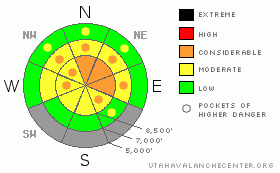
Danger Rose Tutorial
|
Strong winds created areas with a level 3 or Considerable danger on drifted upper and mid elevation slopes, and a couple inches of light snow yesterday hid them well. Dangerous avalanche conditions exist in the backcountry, and you are likely to trigger wind slab avalanches on slopes where drifts formed over weak sugary preexisting snow. To make matters more tricky, obvious drifts are now obscured by yesterday's couple inches of light fresh snow. Evaluate the snow and terrain carefully and avoid steep slopes with accumulations of drifted snow. You'll find safer conditions in sheltered and lower angled terrain, on normally sunny south facing slopes, and at lower elevations.... |
|
|
CURRENT CONDITIONS |

|
You'll find dangerously shallow and baseless snow conditions in the backcountry, with a wide variety of wind and sun crusts now capped by an inch or two of light cold snow. Sugary snow allows you to sink rather deeply and hit rocks or down trees in shady terrain... Looks like a certain change in the weather pattern, with significant heavy snowfall, sustained westerly winds, and warm temperatures on the way, starting tomorrow. These weather factors will cause the avalanche danger to rise significantly, and the backcountry will likely soon become a very scary place. The Tony Grove Snotel reported about 4 inches of new snow from yesterday.... |
|
|
RECENT ACTIVITY |

|
No avalanches have been reported in the Logan Area since skiers remote triggered a hard slab on White Pine Knob on the first day of the New Year. But, my party almost triggered a large hard slab yesterday off the Providence Canyon/Richard's Hollow ridgeline. Instead we remote triggered extensive shooting cracks around a foot deep and 80 feet wide in a drifted starting zone from the ridge top flats 30 feet above. The sizable slab cracked and moved about 2 inches before stopping. (go to our current conditions page for more details and reports of other recent activity in Utah) |
|
|
THREAT #1 |

|
| WHERE |
PROBABILITY |
SIZE |
TREND |

|
|
|
|
| |
|
|
Over the next
24 hours.
|
|
|
Strong southwest winds couldn't find much tired out old snow to drift on Sunday, but still new hard slabs formed and old slabs thickened in exposed terrain. We noted a fair bit of drifting of the new snow in exposed areas yesterday. Hard or soft wind slab avalanches running on weak and sugary faceted snow could be around a foot deep. Watch for and avoid smooth rounded or pillowy wind deposits that often have a chalky appearance and a hollow sound on the lee side of major ridgelines and in and around terrain features like sub-ridges, gullies, scoops and cliff bands. These are likely to be hidden by yesterday's couple inches of light snow, and the only way you'll be able to identify them is by poking into the snow.
Avalanches in some areas with recent drifting might be sensitive or easy to trigger, and you might trigger them remotely from a distance or worse, from below. Harder old wind slabs might be much more stubborn and could allow you to get out on them before releasing.. Even shallow wind slab avalanches could sweep out and entrain significant quantities of weak sugary underlying old snow. Pay attention to signs of instability like cracking and collapsing, and be willing to reevaluate your route or change plans if you encounter red flag conditions... |
|
|
MOUNTAIN WEATHER |

|
We could see a little sunshine and a break in the weather today, but temperatures will remain chilly and southwest winds will increase. Expect the potential for substantial snowfall in the mountains of Far Northern Utah to begin tomorrow morning and continue through next weekend under an increasingly wet, warm, and windy zonal or westerly flow..... Certainly, the welcome change in the weather pattern will bring increasingly dangerous avalanche conditions, and we'll need to mentally prepare to resist the lure of the fresh and all too rare powder on steep slopes in the backcountry.... |
|
|
GENERAL ANNOUNCEMENTS |
Please consider a donation to your favorite non-profit –The Friends of the Utah Avalanche Center. The Utah Avalanche Center depends on contributions from users like you to support our work.....
Please send us your observations from the backcountry especially if you see or trigger an avalanche, but also even if you don't.. go to avalanche and snow observations. You can also call me directly at 435-757-7578 or leave us a message at our office, 801-524-5304.... And, you can always send us a simple email by clicking HERE
I will update this advisory by around 7:30 in the morning on Mondays, Wednesdays, Fridays, and Saturdays.....
This advisory is from the U.S.D.A. Forest Service, which is solely responsible for its content. This advisory describes general avalanche conditions and local variations always occur. |
|
|
This information does not apply to developed ski areas or highways where avalanche control is normally done. This advisory is from the U.S.D.A. Forest Service, which is solely responsible for its content. This advisory describes general avalanche conditions and local variations always occur. |
|
This advisory provided by the USDA Forest Service, in partnership with:
The Friends of the Utah Avalanche Center, Utah Division of State Parks and Recreation, Utah Division of Emergency Management, Salt Lake County, Salt Lake Unified Fire Authority and the friends of the La Sal Avalanche Center. See our Sponsors Page for a complete list. |
