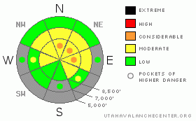
BOTTOM LINE
Danger by aspect and elevation on slopes approaching 35° or steeper.
(click HERE for tomorrow's danger rating)
|
Danger Rose Tutorial
|
There is a level 2 or Moderate avalanche danger in the backcountry, and heightened avalanche conditions exist on wind exposed upper and mid elevation slopes.. In some areas, pockets of a higher level 3 danger probably persist, and you could trigger dangerous persistent slab avalanches on slopes where a stiffer slab consisting of drifted snow formed on top of very weak sugary or faceted snow. Evaluate the snow and terrain carefully this weekend and continue to avoid steep slopes with accumulations of stiffer drifted snow. You'll find safer conditions in sheltered and lower angled terrain, on sunny south facing slopes, and at lower elevations.... |
|
|
CURRENT CONDITIONS |

|
Enjoy the sun, shallow snow, and moderate avalanche danger while they last this weekend, since significant snow is on the way for next week and conditions won't be so nice next weekend. A good load of snow will cause the avalanche danger to rise significantly, and the backcountry will likely soon become a very scary place. The Tony Grove Snotel at 8400' reports 33 inches of total snow on the ground containing a sorry 47% of average water for the date, and its 29 degrees this morning. It's 23 degrees at the 9700' Campbell Scientific Logan Peak weather station. Winds increased from the south-southwest overnight and are now cranking out hourly average windspeeds in the mid thirties this morning... this week we've found a very quiet backcountry and some pretty nice soft Colorado-like sugar snow on north facing slopes and supportable spring-like corn snow on upper elevation south facing slopes. . |
|
|
RECENT ACTIVITY |

|
No avalanches have been reported in the Logan Area since skiers remote triggered a hard slab on White Pine Knob on the first day of the New Year. (go to our current conditions page for more details and reports of recent activity in Utah) |
|
|
THREAT #1 |

|
| WHERE |
PROBABILITY |
SIZE |
TREND |
|
|
|
|
| |
|
|
Over the next
24 hours.
|
|
|
Hard or soft persistent slab avalanches running on weak and sugary faceted snow could be around a foot deep... Avalanches in some areas might be sensitive or easy to trigger, and you might trigger them remotely from a distance or worse, from below. Harder old wind slabs might be much more stubborn and could allow you to get out on them before releasing.. Pay attention to signs of instability like cracking and collapsing, and be willing to reevaluate your route or change plans if you encounter red flag conditions... |
|
|
THREAT #2 |

|
| WHERE |
PROBABILITY |
SIZE |
TREND |

|
|
|
|
| |
|
|
Over the next
24 hours.
|
|
|
Shallow hard wind slab avalanches are possible on steep slopes in areas exposed to recent drifting, and these could sweep out and entrain significant quantities of weak sugary underlying old snow. Watch for and avoid smooth rounded or pillowy wind deposits that often have a chalky appearance and a hollow sound on the lee side of major ridgelines and in and around terrain features like sub-ridges, gullies, scoops and cliff bands. Obviously, even a fairly small avalanche could be quite dangerous if you are caught and swept over shallowly buried rocks or into trees below... |
|
|
MOUNTAIN WEATHER |

|
The high pressure system will start to break down today ahead of a fast moving and windy storm, which will bring a little snow to the area and open the door for a more productive weather pattern for the coming week. Expect warm, breezy, and sunny conditions in the mountains today, with 8000' high temperatures approaching 40 degrees and southwest winds in the twenties along the ridges.. Sunday will be warm and windier still with mostly sunny skies, but clouds increasing in the afternoon. A couple inches of snow will likely accumulate on mountain slopes late Sunday night and Monday morning. The weather pattern should continue to bring gradually increasing warmth, west winds, and Pacific moisture next week, with substantial accumulations possible in the mountains by next weekend.... |
|
|
GENERAL ANNOUNCEMENTS |
Please consider a donation to your favorite non-profit –The Friends of the Utah Avalanche Center. The Utah Avalanche Center depends on contributions from users like you to support our work.....
Please send us your observations from the backcountry especially if you see or trigger an avalanche, but also even if you don't.. go to avalanche and snow observations. You can also call me directly at 435-757-7578 or leave us a message at our office, 801-524-5304.... And, you can always send us a simple email by clicking HERE
I will update this advisory by around 7:30 in the morning on Mondays, Wednesdays, Fridays, and Saturdays.....
This advisory is from the U.S.D.A. Forest Service, which is solely responsible for its content. This advisory describes general avalanche conditions and local variations always occur. |
|
|
This information does not apply to developed ski areas or highways where avalanche control is normally done. This advisory is from the U.S.D.A. Forest Service, which is solely responsible for its content. This advisory describes general avalanche conditions and local variations always occur. |
|
This advisory provided by the USDA Forest Service, in partnership with:
The Friends of the Utah Avalanche Center, Utah Division of State Parks and Recreation, Utah Division of Emergency Management, Salt Lake County, Salt Lake Unified Fire Authority and the friends of the La Sal Avalanche Center. See our Sponsors Page for a complete list. |
