SPECIAL ANNOUNCEMENT |
 |
We will be holding a women's only avalanche awareness class this Thursday evening and Saturday day. It's a great time to take a class despite the low snowpack. Please visit our website for more info or to register: Click HERE |
|
|
BOTTOM LINE
Danger by aspect and elevation on slopes approaching 35° or steeper.
(click HERE for tomorrow's danger rating)
|
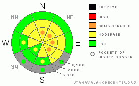
Danger Rose Tutorial
|
There is a level 2 or Moderate avalanche danger in the backcountry, and heightened avalanche conditions exist on many drifted upper and mid elevation slopes.. I've included a few pockets with a higher level 3 danger on upper elevation lee-side drifted slopes. You could trigger dangerous persistent slab avalanches on slopes where a slab of stiffer snow has built up on a base consisting of very weak sugary or faceted snow. Shallow wind slab avalanches are possible on steep slopes in areas exposed to recent drifting... Evaluate the snow and terrain carefully today and avoid steep slopes with accumulations of drifted fresh snow. You'll find safer conditions in sheltered and lower angled terrain, on south facing slopes with a solid sun-crust under a little powder, and at lower elevations.... |
|
|
CURRENT CONDITIONS |

|
Only a few inches of fresh snow fell in the Central Bear River Range over the weekend. At one point on Saturday, the Tony Grove Snotel at 8400' reported a whopping 4 inches of accumulation... Currently there is 33 inches of total snow on the ground containing 53% of average water for the date, and its 25 degrees this morning. It's 23 degrees at the 9700' Campbell Scientific Logan Peak weather station. Winds yesterday were cranking out 20+ hourly averages from the northwest until around dinner time when rime-ice seized up the wind sensor. You'll find very shallow, early season snow conditions and a substantial risk of hitting shallowly buried rocks, stumps, or down trees if you venture off the beaten path. There is no base and it's easy to sink deeply into the sugary and rotten snow once you break through the rime, wind, or sun crusts near the surface in most areas.... |
|
|
RECENT ACTIVITY |

|
Locally: no avalanches were reported since skiers remote triggered a good sized hard slab on the east side of White Pine Knob in upper Bunchgrass Canyon on the first day of 2012... |
|
|
THREAT #1 |

|
| WHERE |
PROBABILITY |
SIZE |
TREND |

|
|
|
|
| |
|
|
Over the next
24 hours.
|
|
|
Hard or soft persistent slab avalanches running on weak and sugary faceted snow could be a foot or more deep and fairly wide. Avalanches in some areas might be sensitive or easy to trigger, and you might trigger them remotely from a distance or worse, from below. . Pay attention to signs of instability like cracking and collapsing, and be willing to reevaluate your route or change plans if you encounter red flag conditions |
|
|
THREAT #2 |

|
| WHERE |
PROBABILITY |
SIZE |
TREND |
|
|
|
|
| |
|
|
Over the next
24 hours.
|
|
|
Shallow wind slab avalanches are possible in exposed terrain. Yesterday's sustained northwest wind drifted the weekend's ration of fresh snow and deposited it on the lee side of major ridgelines and in and around terrain features like gullies and scoops and under cliff bands. Be aware of the possibility of cross-loading or vertical drifting on the lee side of sub-ridges, and watch for substantial loading even with only a few inches of new snow in drifted areas downwind of large low angle openings or fetch areas....
On some slopes, shallow wind slab avalanches might sweep out and entrain significant quantities of very weak sugary old snow. Even a fairly small avalanche could be quite dangerous if you are caught and swept over shallowly buried rocks or into trees below... |
|
|
MOUNTAIN WEATHER |

|
Expect fair and sunny weather in the mountains today, with 8000' temperatures in the mid to upper 30s and a fairly light northwest breeze. Clouds will build up tomorrow, winds will increase a bit and shift around from the southwest, and it will be a few degrees cooler in advance the next pitiful "storm," which will brush by the region Tuesday night... A few flakes are possible, but very little to no snow is forecast.. The high pressure system will reestablish over our area as we head into the later half of the week, and the forecast for the next 7 to 10 days looks pretty bleak and dry... |
|
|
GENERAL ANNOUNCEMENTS |
Please consider a donation to your favorite non-profit –The Friends of the Utah Avalanche Center. The Utah Avalanche Center depends on contributions from users like you to support our work.....
Please send us your observations from the backcountry especially if you see or trigger an avalanche, but also even if you don't.. go to avalanche and snow observations. You can also call me directly at 435-757-7578 or leave us a message at our office, 801-524-5304.... And, you can always send us a simple email by clicking HERE
I will update this advisory by around 7:30 in the morning on Mondays, Wednesdays, Fridays, and Saturdays.....
This advisory is from the U.S.D.A. Forest Service, which is solely responsible for its content. This advisory describes general avalanche conditions and local variations always occur. |
|
|
This information does not apply to developed ski areas or highways where avalanche control is normally done. This advisory is from the U.S.D.A. Forest Service, which is solely responsible for its content. This advisory describes general avalanche conditions and local variations always occur. |
|
This advisory provided by the USDA Forest Service, in partnership with:
The Friends of the Utah Avalanche Center, Utah Division of State Parks and Recreation, Utah Division of Emergency Management, Salt Lake County, Salt Lake Unified Fire Authority and the friends of the La Sal Avalanche Center. See our Sponsors Page for a complete list. |
