BOTTOM LINE
Danger by aspect and elevation on slopes approaching 35° or steeper.
(click HERE for tomorrow's danger rating)
|
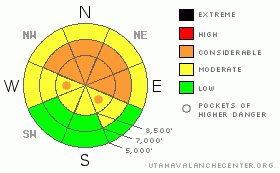
Danger Rose Tutorial
|
There is a level 3 or Considerable avalanche danger in the backcountry, and additional snowfall and drifting will cause a rising danger today. Dangerous avalanche conditions exist and will continue to develop on steep slopes that receive more than around 6 inches of accumulation or drifted fresh snow.. .Careful snowpack evaluation, cautious route-finding, and conservative decision-making will be essential in the backcountry today, and you should avoid steep slopes with significant accumulations or drifted fresh snow .... You'll find safer conditions in sheltered and lower angled terrain, on south facing slopes, and at lower elevations.... |
|
|
CURRENT CONDITIONS |

|
It's 15 degrees at the 9700' Campbell Scientific Logan Peak weather station. Winds shifted around from the northwest overnight, and average wind speeds diminished into the single digits. The Tony Grove Snotel at 8400' reports an inch of snow overnight with 33 inches of total snow on the ground containing 54% of average water for the date, and its 22 degrees this morning. |
|
|
RECENT ACTIVITY |

|
Locally: no avalanches were reported since skiers remote triggered a good sized hard slab last Sunday on the east side of White Pine Knob in upper Bunchgrass Canyon... |
|
|
THREAT #1 |

|
| WHERE |
PROBABILITY |
SIZE |
TREND |
|
|
|
|
| |
|
|
Over the next
24 hours.
|
|
|
The avalanche danger will rise today as more heavy snow accumulates on existing shallow and very weak sugary snow. It won't take much added weight to increase the danger.. Dangerous avalanche conditions probably already exist on steep slopes in some areas and will develop and become more widespread in areas that receive more than about 6 inches of fresh snow... .
Hard or soft persistent slab avalanches could be 1 to 2 feet deep and fairly wide. Avalanches could be quite sensitive or easy to trigger, and you might trigger them remotely from a distance or worse, from below. . On some slopes, shallow wind slab avalanches might sweep out and entrain significant quantities of very weak sugary old snow. Even a fairly small avalanche could be quite dangerous if you are caught and swept over shallowly buried rocks or into trees below.... |
|
|
MOUNTAIN WEATHER |

|
Snowfall may ease up for a spell this morning, but should resume as cold air trailing the front pushes south into the region. Expect temperatures to drop into the teens and moderate northwest winds The mountains south of about Ogden will see the brunt of today's snow, and in the far north we could get the short end of the stick.. Mountain areas in the south part of the Logan Zone could pick up an additional 6 inches of snow, but less than an inch is forecast for the Northern and Central Bear River Range... The high pressure system will reestablish over our area as we head into next week, with another weak disturbance bringing a chance for a little more snow on around Tuesday... |
|
|
GENERAL ANNOUNCEMENTS |
Please consider a donation to your favorite non-profit –The Friends of the Utah Avalanche Center. The Utah Avalanche Center depends on contributions from users like you to support our work.....
Please send us your observations from the backcountry especially if you see or trigger an avalanche, but also even if you don't.. go to avalanche and snow observations. You can also call me directly at 435-757-7578 or leave us a message at our office, 801-524-5304.... And, you can always send us a simple email by clicking HERE
I will update this advisory by around 7:30 in the morning on Mondays, Wednesdays, Fridays, and Saturdays.....
This advisory is from the U.S.D.A. Forest Service, which is solely responsible for its content. This advisory describes general avalanche conditions and local variations always occur. |
|
|
This information does not apply to developed ski areas or highways where avalanche control is normally done. This advisory is from the U.S.D.A. Forest Service, which is solely responsible for its content. This advisory describes general avalanche conditions and local variations always occur. |
|
This advisory provided by the USDA Forest Service, in partnership with:
The Friends of the Utah Avalanche Center, Utah Division of State Parks and Recreation, Utah Division of Emergency Management, Salt Lake County, Salt Lake Unified Fire Authority and the friends of the La Sal Avalanche Center. See our Sponsors Page for a complete list. |
