BOTTOM LINE
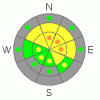
Danger by aspect and elevation on slopes approaching 35° or steeper.
(click HERE for tomorrow's danger rating)
|

Danger Rose Tutorial
|
In general there is a level 2 or Moderate danger in the backcountry, and heightened avalanche conditions exist on previously drifted slopes in the mountains around Logan. I've included a few pockets of higher, level 3 danger, and you'll find some steep slopes with lingering tricky and dangerous avalanche conditions facing east, northeast, and north at upper elevations. Careful snowpack evaluation, cautious route-finding, and conservative decision-making will again be essential in the backcountry today, and you should continue to avoid steep previously wind-drifted slopes.... You'll find safer conditions in sheltered and lower angled terrain, on south facing slopes, and at lower elevations.... |
|
|
CURRENT CONDITIONS |

|
We found enjoyable smooth and supportable spring-like turning conditions in upper elevation south facing terrain yesterday. Elsewhere, last year's December 28 rime-crust is the prevalent feature high in the shallow snowpack, creating very inconsistent snow conditions. Not many people are out riding due to dangerously shallow snow cover and the real potential of serious sled damage. The Tony Grove Snotel at 8400'reports 33 inches of total snow on the ground containing 56% of average water for the date, and its 26 degrees this morning. West-northwest winds are averaging around 20 mph up at the 9700' CSI Logan Peak weather station, where it is currently 17 degrees. |
|
|
RECENT ACTIVITY |

|
Skiers intentionally triggered a couple small persistent slab avalanches on east and northeast facing terrain in the Central Wasatch Range by dropping cornices on suspect slopes below. Locally: no avalanches were reported since skiers remote triggered a good sized hard slab Sunday on the east side of White Pine Knob in upper Bunchgrass...
(Visit our Current Conditions Page for more details..) |
|
|
THREAT #1 |

|
| WHERE |
PROBABILITY |
SIZE |
TREND |
|
|
|
|
| |
|
|
Over the next
24 hours.
|
|
|
Watch out for older deposits of wind drifted snow on weak sugary facets and/or feathery surface hoar, now capped and preserved by a widespread rime-crust in most areas. Very tricky and dangerous avalanche conditions exist in some areas. Pay attention to obvious signs of instability like cracking and collapsing, and as always, be willing to reevaluate and adjust your route. Persistent wind slab avalanches could be 1 to 2 feet deep, and some could be more than 100' wide. Some of these slabs could still be quite sensitive, and you might trigger them remotely from a distance, or worse, from below. Other stiff slabs are likely to be more stubborn, and could trick you into getting out on them before releasing. Avoid stiffer, chalky looking or dusty wind deposited snow on the lee sides of ridges and sub-ridges and in and around terrain features like gullies, scoops, and cliff bands.
Wind loading from the end-of-the-year storm occurred low on some lee slopes, so be aware of the potential for mid-slope avalanches. On some slopes, shallow wind slab avalanches might sweep out and entrain significant quantities very weak sugary old snow. Even a fairly small avalanche could be quite dangerous if you are caught and swept over shallowly buried rocks or into trees below.... |
|
|
MOUNTAIN WEATHER |

|
Expect westerly winds and increasing clouds to keep mountain temperatures several degrees cooler today than yesterday. High temperatures at 8000' are expected to warm to around 35 degrees. A splitting storm system will affect the Logan Forecast Zone tomorrow, with a bit of snow possible... Currently only an inch or so is forecast, but several inches might accumulate in a best case scenario.... Temperatures will drop in any case by tomorrow night, and northwest winds will increase a bit.... The high pressure system will reestablish over our area as we head into next week, with another weak disturbance bringing a chance for a little more snow on around Tuesday... |
|
|
GENERAL ANNOUNCEMENTS |
Please consider a donation to your favorite non-profit –The Friends of the Utah Avalanche Center. The Utah Avalanche Center depends on contributions from users like you to support our work.....
Please send us your observations from the backcountry especially if you see or trigger an avalanche, but also even if you don't.. go to avalanche and snow observations. You can also call me directly at 435-757-7578 or leave us a message at our office, 801-524-5304.... And, you can always send us a simple email by clicking HERE
I will update this advisory by around 7:30 in the morning on Mondays, Wednesdays, Fridays, and Saturdays.....
This advisory is from the U.S.D.A. Forest Service, which is solely responsible for its content. This advisory describes general avalanche conditions and local variations always occur. |
|
|
This information does not apply to developed ski areas or highways where avalanche control is normally done. This advisory is from the U.S.D.A. Forest Service, which is solely responsible for its content. This advisory describes general avalanche conditions and local variations always occur. |
|
This advisory provided by the USDA Forest Service, in partnership with:
The Friends of the Utah Avalanche Center, Utah Division of State Parks and Recreation, Utah Division of Emergency Management, Salt Lake County, Salt Lake Unified Fire Authority and the friends of the La Sal Avalanche Center. See our Sponsors Page for a complete list. |
