SPECIAL ANNOUNCEMENT |
 |
Please join us for a special Advanced Avalanche Skills Workshop presented by the Friends of the Utah Avalanche Center in Logan this coming weekend.. We'll do an evening classroom session on Thursday January 5 starting at 6:00 downstairs at the Logan Ranger District Offices and a day-long field session on Saturday January 7....For more information and to sign up for the class go..... Here |
|
|
BOTTOM LINE
Danger by aspect and elevation on slopes approaching 35° or steeper.
(click HERE for tomorrow's danger rating)
|
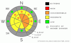
Danger Rose Tutorial
|
There is a level 3 or Considerable danger on previously drifted slopes in the backcountry around Logan. You'll find tricky and dangerous avalanche conditions at upper and mid-elevations, mainly on slopes facing the eastern side of the compass. Human triggered avalanches remain probable on steep previously drifted slopes. Warm conditions will cause a heightened danger of wet avalanches on some sunny slopes.
Be aware that most avalanche accidents in Utah occur during times when we've rated the danger at level 3. Careful snowpack evaluation, cautious route-finding, and conservative decision-making will be essential in the backcountry today, and you should avoid steep previously wind-drifted slopes.... You'll find safer conditions in sheltered and lower angled terrain, out from under steep slopes, and at lower elevations.... |
|
|
CURRENT CONDITIONS |

|
Once again it'll be warm, clear, and very sunny in the mountains today. Unfortunately, snow conditions are crusty, droppy, and generally less than desirable. You sink right through the crust and into deep sugary snow in many areas if you ride off the beaten path, and several sledders I've spoken to recently complain of significant equipment damage after tagging shallowly buried rocks..... The Tony Grove Snotel at 8400'reports 33 inches of total snow on the ground containing 58% of average water for the date, and its a balmy 34 degrees. West winds are averaging around 20 mph up at the 9700' CSI Logan Peak weather station, where it is currently 30 degrees. |
|
|
RECENT ACTIVITY |

|
Very tricky and dangerous avalanche conditions exist in some areas, and the danger will probably linger for some time due to the persistent nature of the sugary or faceted weak layers, now nicely preserved under a shallowly buried creme brulee rime-crust...
A handful of remote triggered avalanches were reported from Monday in the Central Wasatch Range, with drifted Park City side slopes seemingly the most active... Yesterday Craige and Ted noticed a large unreported sled-triggered avalanche from Monday afternoon in Moffit Basin in the Western Uintas.... Locally: skiers remote triggered a good sized hard slab Sunday afternoon on the east side of White Pine Knob in upper Bunchgrass... The 1'+ deep and around 100' wide persistent slab avalanche on a steep mid-slope roll was triggered from 50-75 feet away and off to the side... It is likely that similar conditions exist on many other slopes in the Logan Zone...
(Visit our Current Conditions Page for more details..) |
|
|
THREAT #1 |

|
| WHERE |
PROBABILITY |
SIZE |
TREND |
|
|
|
|
| |
|
|
Over the next
24 hours.
|
|
|
Watch out for older deposits of wind drifted snow on weak sugary facets and/or feathery surface hoar, now capped and preserved by a widespread rime-crust in most areas. Very tricky and dangerous avalanche conditions exist in some areas. Pay attention to obvious signs of instability like cracking and collapsing, and as always, be willing to reevaluate and adjust your route. Persistent wind slab avalanches could be 1 to 2 feet deep, and some could be more than 100' wide. Some of these slabs could still be quite sensitive, and you might trigger them remotely from a distance, or worse, from below. Other stiff slabs are likely to be more stubborn, and could trick you into getting out on them before releasing. Avoid stiffer, chalky looking or dusty wind deposited snow on the lee sides of ridges and sub-ridges and in and around terrain features like gullies, scoops, and cliff bands.
Wind loading from the end-of-the-year storm occurred low on some lee slopes, so be aware of the potential for mid-slope avalanches. On some slopes, shallow wind slab avalanches might sweep out and entrain significant quantities very weak sugary old snow. Even a fairly small avalanche could be quite dangerous if you are caught and swept over shallowly buried rocks or into trees below.... |
|
|
THREAT #2 |

|
| WHERE |
PROBABILITY |
SIZE |
TREND |

|
|
|
|
| |
|
|
Over the next
10 hours.
|
|
|
Mountain temperatures will be quite warm again today, and some slopes will soften to the point of becoming prone to wet avalanches.... If you start sinking into saturated snow or initiate sluffs or roller balls you should head for shady cooler terrain or home. The warmth may cause some of the existing hard slabs to soften up, which could make them easier to trigger.... |
|
|
MOUNTAIN WEATHER |

|
Once again, we'll see lots of sunshine, and it will be very warm in the mountains today....Expect 8500' high temperatures up around 43 degrees and a westerly breeze.... The benign weather pattern looks like it'll persist through at least the balance of the week, with a slight chance of a little snow coming on Saturday... The high pressure ridge will reestablish itself over our area and persist through at least the middle part of next week... |
|
|
GENERAL ANNOUNCEMENTS |
Please consider a donation to your favorite non-profit –The Friends of the Utah Avalanche Center. The Utah Avalanche Center depends on contributions from users like you to support our work.....
Please send us your observations from the backcountry especially if you see or trigger an avalanche, but also even if you don't.. go to avalanche and snow observations. You can also call me directly at 435-757-7578 or leave us a message at our office, 801-524-5304.... And, you can always send us a simple email by clicking HERE
I will update this advisory by around 7:30 in the morning on Mondays, Wednesdays, Fridays, and Saturdays.....
This advisory is from the U.S.D.A. Forest Service, which is solely responsible for its content. This advisory describes general avalanche conditions and local variations always occur. |
|
|
This information does not apply to developed ski areas or highways where avalanche control is normally done. This advisory is from the U.S.D.A. Forest Service, which is solely responsible for its content. This advisory describes general avalanche conditions and local variations always occur. |
|
This advisory provided by the USDA Forest Service, in partnership with:
The Friends of the Utah Avalanche Center, Utah Division of State Parks and Recreation, Utah Division of Emergency Management, Salt Lake County, Salt Lake Unified Fire Authority and the friends of the La Sal Avalanche Center. See our Sponsors Page for a complete list. |
