SPECIAL ANNOUNCEMENT |
 |
A special avalanche advisory has been issued for the mountains of northern and central Utah. Dangerous avalanche conditions exist. Strong winds are blowing snow into drifts that can be easily triggered by people on steep slopes and from a distance. Backcountry travel in steep avalanche terrain is not recommended. |
|
|
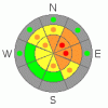
BOTTOM LINE
Danger by aspect and elevation on slopes approaching 35° or steeper.
(click HERE for tomorrow's danger rating)
|

Danger Rose Tutorial
|
There is a level 3 or Considerable danger on drifted slopes in the backcountry around Logan. You'll find dangerous avalanche conditions and you are likely to trigger avalanches on steep slopes with significant deposits of recently drifted snow. I've included a couple pockets of level 4 or High danger at upper elevations on east facing slopes that are downwind of large open fetch areas. Careful snowpack evaluation, cautious route-finding, and conservative decision-making will be essential in the backcountry today, and you should avoid steep slopes with recent deposits of wind drifted snow.... |
|
|
CURRENT CONDITIONS |

|
It'll be cold and windy in the mountains today, and the couple inches of fresh snow from overnight will be easily drifted off a smooth and glassy rain crust and into lee slope and wind break deposition areas...The Tony Grove Snotel at 8400'reports 3 inches of heavy snow overnight containing a half inch of water. There is 33 inches of total snow on the ground containing 60% of average water for the date. West winds sustained 25 mph average wind speeds again overnight, with a gust of 54 mph reported up at the 9700' CSI Logan Peak weather station, where it is currently a chilly 6 degrees. I found a widespread brittle and translucent rain-crust at higher elevations in the Franklin Basin Area yesterday. This formed with the rain on 12-28 and is capping very weak sugary or faceted underlying snow and preventing the older snow from being drifted. The inch or so of newer snow was completely blown off the crust in vast areas, with deep drifts downwind of large fetches in isolated wind break deposition areas.... |
|
|
RECENT ACTIVITY |

|
We've received reports of a couple remote triggered wind slab avalanches from exposed terrain in the Central Wasatch Range. Also, two remote triggered avalanches running on weak faceted snow and stepping to the ground were reported yesterday in the eastern Uintas. Locally, no one has reported any avalanches recently... |
|
|
THREAT #1 |

|
| WHERE |
PROBABILITY |
SIZE |
TREND |
|
|
|
|
| |
|
|
Over the next
24 hours.
|
|
|
Watch out for deposits of wind drifted new snow on weak sugary facets or feathery surface hoar. now capped and preserved by the rain crust in many areas. Wind slab avalanches could be up to around a foot deep. Some of these could be quite sensitive, and you might trigger them remotely. Others are likely to be more stubborn, and could allow you to get out on them before releasing.
*** Avoid stiffer, chalky looking wind deposited snow on the lee sides of ridges and subridges and in and around terrain features like gullies, scoops, and cliff bands. Slopes downwind of large open fetch areas will be the most dangerous today. On some slopes, shallow wind slab avalanches might sweep out and entrain significant quantities very weak sugary old snow. Even a fairly small avalanche could be quite dangerous if you are caught and swept over shallowly buried rocks or into trees below.... Pay attention to obvious signs of instability like cracking and collapsing, and be willing to reevaluate your route. |
|
|
MOUNTAIN WEATHER |

|
It will be pretty cold and very windy in the mountains today, with continuing strong west-northwest winds and high temperatures in the lower twenties forecast. But don't worry, it'll warm up soon enough in the mountains as a high pressure system will again begin to gain control of the weather pattern, and benign weather is expected through most of next week.... |
|
|
GENERAL ANNOUNCEMENTS |
Please consider an end of the year donation to your favorite non-profit –The Friends of the Utah Avalanche Center. The Utah Avalanche Center depends on contributions from users like you to support our work.....
Please send us your observations from the backcountry especially if you see or trigger an avalanche, but also even if you don't.. go to avalanche and snow observations. You can also call me directly at 435-757-7578 or leave us a message at our office, 801-524-5304.... And, you can always send us a simple email by clicking HERE
I will update this advisory by around 7:30 in the morning on Mondays, Wednesdays, Fridays, and Saturdays.....
This advisory is from the U.S.D.A. Forest Service, which is solely responsible for its content. This advisory describes general avalanche conditions and local variations always occur. |
|
|
This information does not apply to developed ski areas or highways where avalanche control is normally done. This advisory is from the U.S.D.A. Forest Service, which is solely responsible for its content. This advisory describes general avalanche conditions and local variations always occur. |
|
This advisory provided by the USDA Forest Service, in partnership with:
The Friends of the Utah Avalanche Center, Utah Division of State Parks and Recreation, Utah Division of Emergency Management, Salt Lake County, Salt Lake Unified Fire Authority and the friends of the La Sal Avalanche Center. See our Sponsors Page for a complete list. |
