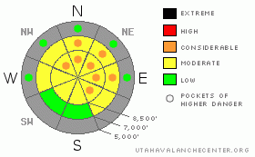
BOTTOM LINE
Danger by aspect and elevation on slopes approaching 35° or steeper.
(click HERE for tomorrow's danger rating)
|
Danger Rose Tutorial
|
There is a level 2 or Moderate danger in most terrain in the backcountry around Logan. You'll find heightened avalanche conditions and you could trigger avalanches in terrain exposed to wind drifting and on steep slopes with existing weak snow. There are also pockets with a level 3 or Considerable danger, and more dangerous avalanche conditions probably exist on some wind drifted slopes where stiff wind slabs formed on weak sugary or faceted snow. Careful snowpack evaluation, cautious route-finding, and conservative decision-making will be essential in the backcountry today.
*** Avoid steep slopes with recent deposits of wind drifted snow.... |
|
|
CURRENT CONDITIONS |

|
The snow stayed mostly well to our north, and you'll have to head up to Idaho or Wyoming if you want much in the way of fresh powder. In the last couple days, the mountains of far northern Utah have only picked up a couple inches of heavy snow, graupel, and a few rain drops. The Tony Grove Snotel at 8400'reports an inch of new snow from yesterday, and like most of the other Bear River Range sites, around 4/10ths of an inch of water in the last 48 hours. There is 30 inches of total snow on the ground containing 58% of average water for the date. Southwest winds picked up again overnight, with 25 mph average wind speeds and gusts of 45 mph reported up at the 9700' CSI Logan Peak weather station, where it is currently a balmy 27 degrees. |
|
|
RECENT ACTIVITY |

|
We've received reports of a couple shallow intentionally triggered wind slab avalanches from exposed east facing terrain in the Central Wasatch Range... Locally, no one has reported any avalanches other than dry loose sluffing of weak and sugary faceted snow in very steep terrain.. |
|
|
THREAT #1 |

|
| WHERE |
PROBABILITY |
SIZE |
TREND |
|
|
|
|
| |
|
|
Over the next
24 hours.
|
|
|
Watch out for deposits of wind drifted new snow on weak sugary facets or feathery surface hoar. Wind slab avalanches could be up to around a foot deep. Some of these could be quite sensitive, and you might trigger them remotely. Others are likely to be more stubborn, and could allow you to get out on them before releasing.
*** Avoid stiffer, chalky looking wind deposited snow on the lee sides of ridges and subridges and in and around terrain features like gullies, scoops, and cliff bands. On some slopes, shallow wind slab avalanches might sweep out and entrain significant quantities very weak sugary old snow. Even a fairly small avalanche could be quite dangerous if you are caught and swept over shallowly buried rocks or into trees below.... Pay attention to obvious signs of instability like cracking and collapsing, and be willing to reevaluate your route. |
|
|
THREAT #2 |

|
| WHERE |
PROBABILITY |
SIZE |
TREND |

|
|
|
|
| |
|
|
Over the next
24 hours.
|
|
|
Loose dry or moist surface sluffs may entrain significant volumes of very weak preexisting sugary or faceted snow on very steep slopes. You should avoid terrain where you could be swept into terrain traps like gullies, rocks or trees below.. |
|
|
MOUNTAIN WEATHER |

|
Expect warm and windy conditions in the mountains today, with another inch or so of snow possible this morning... A cold front will swing through the region tonight bringing an increase in westerly winds and a significant drop in temperatures, with 8500' overnight lows in the single digits. An inch or two of new snow may accumulate. It will be pretty cold and very windy in the mountains tomorrow, with strong northwest winds and high temperatures in the lower twenties forecast. But don't worry, it'll warm up in the mountains next week as a high pressure system will again gain control of the weather pattern...... |
|
|
GENERAL ANNOUNCEMENTS |
Please consider an end of the year donation to your favorite non-profit –The Friends of the Utah Avalanche Center. The Utah Avalanche Center depends on contributions from users like you to support our work.....
Please send us your observations from the backcountry especially if you see or trigger an avalanche, but also even if you don't.. go to avalanche and snow observations. You can also call me directly at 435-757-7578 or leave us a message at our office, 801-524-5304.... And, you can always send us a simple email by clicking HERE
I will update this advisory by around 7:30 in the morning on Mondays, Wednesdays, Fridays, and Saturdays.....
This advisory is from the U.S.D.A. Forest Service, which is solely responsible for its content. This advisory describes general avalanche conditions and local variations always occur. |
|
|
This information does not apply to developed ski areas or highways where avalanche control is normally done. This advisory is from the U.S.D.A. Forest Service, which is solely responsible for its content. This advisory describes general avalanche conditions and local variations always occur. |
|
This advisory provided by the USDA Forest Service, in partnership with:
The Friends of the Utah Avalanche Center, Utah Division of State Parks and Recreation, Utah Division of Emergency Management, Salt Lake County, Salt Lake Unified Fire Authority and the friends of the La Sal Avalanche Center. See our Sponsors Page for a complete list. |
