SPECIAL ANNOUNCEMENT |
 |
Please consider an end of the year donationto your favorite non-profit –The Friends of the Utah Avalanche Center. The Utah Avalanche Center depends on contributions from users like you to support our work..... |
|
|
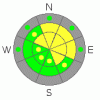
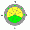
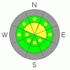
BOTTOM LINE
Danger by aspect and elevation on slopes approaching 35° or steeper.
(click HERE for tomorrow's danger rating)
|

Danger Rose Tutorial
|
There is a level 2 or Moderate danger and heightened avalanche conditions in the backcountry. You could trigger stiff wind slab avalanches running on shallowly buried persistent weak layers on some steep drifted slopes. Also, you are still likely to trigger loose dry sluffs on slopes steeper than around 40 degrees, which could entrain significant volumes of snow and be potentially long running. In both cases, the greatest danger to you may come from being swept into shallowly buried rocks or trees below. The danger will rise on Thursday, with gradually accumulating snow, warming temperatures, and fairly strong westerly winds forecast. You should continue to evaluate the snow and terrain carefully in steep upper and mid-elevation terrain and avoid drifted slopes.. |
|
|
CURRENT CONDITIONS |

|
The 9700' CSI Logan Peak weather station reports winds averaging over 30 mph from the west-southwest this morning with gusts of 45, and a current temperature of 18 degrees. The Tony Grove Snotel at 8400'reports an angry inch of new snow from yesterday and 27 degrees, and there is 30 inches of total snow on the ground containing a meager 57% of average water for the date. Shallow and weak snow cover means that crashing into shallowly buried rocks or down trees presents a serious risk.... |
|
|
RECENT ACTIVITY |

|
Observers in the Wasatch Range and locally continue to report easily triggered and long running sluffs, which entrain all the loose sugary or faceted snow and gouge down to the bottom of the snowpack. A couple triggered soft slabs involving old snow were reported by separate parties on Monday in the Central Wasatch. (see reports on the Current Conditions Page) |
|
|
THREAT #1 |

|
| WHERE |
PROBABILITY |
SIZE |
TREND |
|
|
|
|
| |
|
|
Over the next
48 hours.
|
|
|
Watch out for deposits of wind drifted snow on weak sugary facets or feathery surface hoar. Wind slab avalanches could be up to around a foot deep and you might trigger them remotely, from a distance or below.. Avoid stiffer, wind drifted fresh snow on the lee sides of ridges and subridges and in and around terrain features like gullies, scoops, and cliff bands. Even a fairly small avalanche could be quite dangerous if you are caught and swept over shallowly buried rocks or into trees below.... |
|
|
THREAT #2 |

|
| WHERE |
PROBABILITY |
SIZE |
TREND |
|
|
|
|
| |
|
|
Over the next
24 hours.
|
|
|
Triggered loose dry sluffs entraininug significant volumes of weak sugary snow are again probable on very steep slopes with unconsolidated snow, so avoid terrain where you could be swept into gullies, rocks or trees below.. Be sure you are not above or below your partners or other parties, and be sure to watch above as you descend. |
|
|
THREAT #3 |

|
| WHERE |
PROBABILITY |
SIZE |
TREND |
|
|
|
|
| |
|
|
Over the next
48 hours.
|
|
|
Slab avalanches involving old faceted November snow are possible on some steep slopes, mainly in upper elevation exposed terrain. The two triggered soft slabs from Monday in the Wasatch illustrate the potential. Drifting of the gradually accumulating fresh snow on slopes with existing weak snow cover will cause the danger of persistent slab avalanches to rise in the next couple days. |
|
|
MOUNTAIN WEATHER |

|
An increasingly moist zonal or westerly flow will continue over our area. A series of fast moving but weak disturbances should continue to break up the inversion and bring some accumulating snow and somewhat windy conditions to the mountains. Expect minimal accumulations today and tonight, with a few inches possible tomorrow and sustained westerly winds..Temperatures in the mountains will be mild, with daytime highs nearing 40 degrees by tomorrow and overnight lows remaining in the upper twenties.... |
|
|
GENERAL ANNOUNCEMENTS |
Please send us your observations from the backcountry especially if you see or trigger an avalanche, but also even if you don't.. go to avalanche and snow observations. You can also call me directly at 435-757-7578 or leave us a message at our office, 801-524-5304.... And, you can always send us a simple email by clicking HERE
I will update this advisory by around 7:30 in the morning on Mondays, Wednesdays, Fridays, and Saturdays.....
This advisory is from the U.S.D.A. Forest Service, which is solely responsible for its content. This advisory describes general avalanche conditions and local variations always occur. |
|
|
This information does not apply to developed ski areas or highways where avalanche control is normally done. This advisory is from the U.S.D.A. Forest Service, which is solely responsible for its content. This advisory describes general avalanche conditions and local variations always occur. |
|
This advisory provided by the USDA Forest Service, in partnership with:
The Friends of the Utah Avalanche Center, Utah Division of State Parks and Recreation, Utah Division of Emergency Management, Salt Lake County, Salt Lake Unified Fire Authority and the friends of the La Sal Avalanche Center. See our Sponsors Page for a complete list. |
