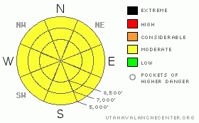
BOTTOM LINE
Danger by aspect and elevation on slopes approaching 35° or steeper.
(click HERE for tomorrow's danger rating)
|
Danger Rose Tutorial
|
There is a MODERATE danger in the backcountry, and you could trigger dangerous stiff or hard wind slab avalanches on some very steep, recently or previously drifted slopes. The danger is greatest on exposed upper elevation slopes facing the eastern half of the compass. Dangerous avalanche conditions may linger on isolated steep slopes with persistent weak layers and significant deposits of wind-drifted snow.
Warming and sunshine in the next few days will cause an increasing danger of wet avalanches. Wet avalanches will become likely on steep slopes when fresh surface snow is initially saturated . Continue to avoid and stay out from under huge and often deceitful ridge-top cornices, which were built out again significantly in the past couple days and will sag and buckle in the inevitable warming temperatures to come...Evaluate the snow and terrain carefully and use good travel habits.... |
|
|
CURRENT CONDITIONS |

|
Looks like we missed out on most of the snow from this storm, with no snow reported at the Tony Grove Snotel overnight...The station reports a snow total of 108 inches containing 105% of average water content for the date. Looks like we'll still be playing around in the stiffer snow from Wednesday, and if you want deep powder you need to head down to the Central Wasatch Range, where snow safety crews are reporting around 2 feet of new snow in the last 24 hours....If you stay in the Cache, Beaver Mountain will be open today as a special final encore bonus for season pass holders and local riders...Thank you Marge and Ted.
The wind sensor at the Campbell Scientific weather station at 9700' on Logan Peak reports a 10 mph north wind this morning, and it's 14 degrees. The remote sensors up at Beaver Mountain show me an inch of new snow and it's currently16 degrees. |
|
|
RECENT ACTIVITY |

|
A few backcountry skiers triggered wind slab avalanches consisting of new snow yesterday in the Central Wasatch Range and one skier took a ride when a steep slope that had been previously ski cut released above him. (Salt Lake Area Advisory)
On Wednesday, I observed several good sized natural wind slab avalanches in the Wellsville Range, which occurred overnight on March 31st. I went up and looked at a couple that were triggered by very large cornice falls. These stepped down into persistent buried weak layers and ran well over 2000 vertical feet down onto Maple Bench. (4-1-09 PHOTOS) |
|
|
THREAT #1 |

|
| WHERE |
PROBABILITY |
SIZE |
TREND |

|
|
|
|
| |
|
|
Over the next
24
hours.
|
|
|
Strong winds all day long Thursday built stiff wind slabs and extended overhangs on cornices. (4-2-09 Photos).
.. There are now actually a few different buried weak layers that could produce deeper releases in the Logan Area. Recently in some areas, I've found potentially persistent weak layers consisting of small near surface facets just above the hard melt-freeze crust from the warm spell two weeks ago, also thin layers of airy graupel, and now a clean shear on a recent storm interface with surface hoar.
You could trigger older wind slab or hard persistent slab avalanches on some very steep previously drifted slopes. |
|
|
THREAT #2 |

|
| WHERE |
PROBABILITY |
SIZE |
TREND |

|
|
|
|
| |
|
|
Over the next
24
hours.
|
|
|
Warm overnight temperatures, rain, seasonally common direct solar warming, and/or greenhousing could cause lower and mid-elevation snow to become saturated. If this is the case, loose wet avalanches involving moist new snow will become likely on steep slopes. Fresh snow can become saturated and unstable very quickly this time of year. The danger will increase with solar warming tomorrow and in the next couple days, with the first significant clearing after lots of fresh snowfall in the last couple weeks.... |
|
|
THREAT #3 |

|
| WHERE |
PROBABILITY |
SIZE |
TREND |
|
|
|
|
| |
|
|
Over the next
24
hours.
|
|
|
Continue to avoid and stay out from under huge ridge-top cornices...Some of these deceitful monsters, having been built out again hugely in the past few days, could be sensitive to your weight today. Cornices often break further back and/or wider than expected... Many of the local cornices are now way too big to mess around with, even on belay.
(3-28-09 PHOTO) |
|
|
MOUNTAIN WEATHER |

|
Looks like we got skunked, with more accumulation on the valley floor last night than up at Tony Grove. It should stay cloudy and fairly cold today, with periods of snow likely, but not much accumulation forecast. We'll be lucky to see two or three inches before a high pressure noses into the region overnight. Expect clearing and warming conditions and a resumption of the melt early next week, with Tuesday looking especially mild...The next Pacific storm will impact the region on around Tuesday night.... |
|
|
GENERAL ANNOUNCEMENTS |
Our "Know before You Go" video is available online..... (click HERE to watch it)
Please let us know what you're seeing in the backcountry, especially if you see or trigger an avalanche, by leaving us a message at (435-)755-3638 or 1-800-662-4140. Or, you can always e-mail us at uac@utahavalanchecenter.org. . Your observations are very important for our program.....
The Utah Avalanche Center depends on contributions from users like you to support our work.
This will be the last regularly updated advisory of the season, and I will be leaving town for several days for spring break with the family. I will, however, resume intermittent and weekend advisories through the rest of April..... I will update this advisory by about 7:30 on Friday morning...
This advisory is from the U.S.D.A. Forest Service, which is solely responsible for its content. This advisory describes general avalanche conditions and local variations always occur. |
|
|
This information does not apply to developed ski areas or highways where avalanche control is normally done. This advisory is from the U.S.D.A. Forest Service, which is solely responsible for its content. This advisory describes general avalanche conditions and local variations always occur. |
|
This advisory provided by the USDA Forest Service, in partnership with:
The Friends of the Utah Avalanche Center, Utah Division of State Parks and Recreation, Utah Division of Emergency Management, Salt Lake County, Salt Lake Unified Fire Authority and the friends of the La Sal Avalanche Center. See our Sponsors Page for a complete list. |
