SPECIAL ANNOUNCEMENT |
 |
You can get a great deal on further discounted tickets to Beaver Mountain and support the Utah Avalanche Center at the same time. 100% of the funds raised from these donated lift tickets will go to the Friends of the Utah Avalanche Center and will help our financially strapped but important program...(Click HERE to get discounted tickets on-line) |
|
|
BOTTOM LINE
Danger by aspect and elevation on slopes approaching 35° or steeper.
(click HERE for tomorrow's danger rating)
|
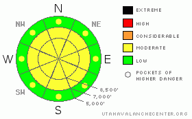
Danger Rose Tutorial
|
There is a MODERATE danger in the backcountry, and you could trigger loose snow or soft wind slab avalanches consisting of new snow on some slopes steeper than about 35 degrees. There is also a lingering danger of triggering harder and deeper wind slabs on very steep previously drifted slopes, mainly in exposed upper elevation terrain. A buried weak layer exists on some shady slopes and the danger of scary persistent slab avalanches is gradually rising as accumulating snow slowly builds a slab on top of it.
The danger will be greatest in areas that might pick up significant additional accumulations of new snow today. Evaluate the snow and terrain carefully and use wise travel protocols. |
|
|
CURRENT CONDITIONS |

|
Cold temperatures preserved nice settled powder conditions throughout the region. The southern part of the Bear River Mountains, especially western slopes, and the Wellsville Range picked up a good deal more snow than the mountains north of around Logan Canyon over the last week. The Tony Grove Snotel recorded three-and-a-half inches of accumulation of light snow overnight, containing 2/10ths of an inch of water. The CSI weather station on Logan Peak at 9700' reports 10 degrees and a fairly light southwest breeze.
Expect snowfall today with a continued light southwesterly winds. The Wellsville Range, the Ogden Mountains, and western slopes of the Southern Bear River Range are once again likely to get more snow under these classic southwest flow conditions. |
|
|
RECENT ACTIVITY |

|
It has been an active week locally. The increase in wind on Tuesday spawned numerous natural shallow loose and a few shallow soft slab avalanches in upper elevation areas that received significant snowfall on Monday.
Wednesday afternoon a snowmobiler triggered a wind slab avalanche on Horse Ridge south of Providence Peak. The 2 foot deep by 50' wide avalanche involved drifted snow near a ridge-top and didn't run very far, but it shows that larger triggered wind slab avalanches are a possibility. (2/12/09 photos)
Observers reported seeing a small recent natural wind slab (from Thursday) in exposed lower elevation terrain in the Providence Gravel Pit Area. 8" deep and 20' wide...And a few natural loose wet avalanches rolled down steep sunny slopes in the Wellsville Range with yesterday's solar heating. |
|
|
THREAT #1 |

|
| WHERE |
PROBABILITY |
SIZE |
TREND |
|
|
|
|
| |
|
|
Over the next
24
hours.
|
|
|
A few inches of light snow fell overnight and there's already lots of nice soft snow on the surface in many areas. Lots of natural and human triggered loose snow avalanches or sluffs occurred in the past week, and they'll be likely again today on steep slopes. These are usually harmless and even somewhat fun, but you have to be careful messing around on steep slopes with potential terrain traps below you, particularly gullies. Soft wind slabs consisting of light new snow will continue build today in exposed terrain and around upper elevation ridge lines.
Stiff, previously built wind slabs are now fairly well bonded to the underlying snow for the most part. But, you could trigger dangerous wind slab avalanches on very steep drifted slopes in exposed terrain, mainly at upper elevations. |
|
|
THREAT #2 |

|
| WHERE |
PROBABILITY |
SIZE |
TREND |

|
|
|
|
| |
|
|
Over the next
24
hours.
|
|
|
We've still been able to find a weak layer consisting of well preserved surface hoar or feathery frost crystals, which was shallowly buried a week ago yesterday. (2/8/09 photo)
This type of snow has a nasty reputation as a persistent weak layer that can commonly lay docilely hidden in the snowpack for some time before a slab builds the right properties for it to become reactive. Because of their tricky nature, avalanches running on surface hoar account for most avalanche accidents in North America Although it doesn't look like we'll get too much accumulation, this weekend's storm might cause the slab layer to reach this critical state I refer to in some areas, and the danger of deadly persistent slabs is gradually rising. |
|
|
MOUNTAIN WEATHER |

|
Today's storm is currently dropping snow primarily from the Salt Lake Valley southward, but radar indicates a little slow movement toward the north...Light snow should continue through this afternoon in the mountains, but the National Weather Service in SLC forecasts only light accumulations for the mountains around Logan today. The storm will move off to our east this evening allowing for ridging and partial clearing tomorrow. A larger and more powerful storm with strong winds and potentially significant accumulations will impact the region with a strong cold front early Tuesday. Another potent storm is setting up for later in the work week. |
|
|
GENERAL ANNOUNCEMENTS |
The Friends of the Utah Avalanche Center and the USU Outdoor Recreation Center are offering a four-day intensive advanced backcountry avalanche Level 2 (certification) class next weekend. The class starts on Thursday evening (2/19/09), and we'll spend the next 3 days in the field. Please call the ORC to register in advance. (435-797-3264)
Our "Know before You Go" video is available online..... (click HERE to watch it)
The UAC depends on contributions from users like you to support our work. To find out more about how you can support our efforts to continue providing the avalanche forecasting and education that you expect please visit our Friends page.
Your snow and avalanche observations help everyone in the backcountry community. Please let us know what you're seeing by leaving a message at (435-)755-3638 or 1-800-662-4140, or email us at uac@utahavalanchecenter.org. .
This advisory is from the U.S.D.A. Forest Service, which is solely responsible for its content. This advisory describes general avalanche conditions and local variations always occur.
I will update this advisory by around 7:30 Monday morning. |
|
|
This information does not apply to developed ski areas or highways where avalanche control is normally done. This advisory is from the U.S.D.A. Forest Service, which is solely responsible for its content. This advisory describes general avalanche conditions and local variations always occur. |
|
This advisory provided by the USDA Forest Service, in partnership with:
The Friends of the Utah Avalanche Center, Utah Division of State Parks and Recreation, Utah Division of Emergency Management, Salt Lake County, Salt Lake Unified Fire Authority and the friends of the La Sal Avalanche Center. See our Sponsors Page for a complete list. |
