SPECIAL ANNOUNCEMENT |
 |
You can get a great deal on further discounted tickets to Beaver Mountain and support the Utah Avalanche Center at the same time. 100% of the funds raised from these donated lift tickets will go to the Friends of the Utah Avalanche Center and will help our financially strapped but important program...(Click HERE to get discounted tickets on-line) |
|
|
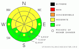
BOTTOM LINE
Danger by aspect and elevation on slopes approaching 35° or steeper.
(click HERE for tomorrow's danger rating)
|
Danger Rose Tutorial
|
There is a MODERATE danger in the backcountry, and you could trigger wind slab or persistent slab avalanches on some drifted slopes steeper than about 35 degrees...The danger will rise this weekend with both wind and snow in the forecast and buried weak layers existing on many slopes in the region. |
|
|
CURRENT CONDITIONS |

|
The Central Bear River Range missed out on much of the recent snowfall, but there are still good soft mid-winter snow conditions across the region. The southern part of the range, especially western slopes, and the Wellsville Range picked up a good amount of light powder from Monday's storm in a southwest flow. Ridge-top winds picked up a bit on Tuesday and Wednesday, drifting snow in exposed terrain and building stiff wind slabs in some places. It was mostly calm yesterday and temperatures remained cold throughout this week, so there's lots of nice light powder on the surface, especially in sheltered terrain.
The CSIweather station on Logan Peak at 9700' reports 6 degrees and a 10 mph westerly breeze. |
|
|
RECENT ACTIVITY |

|
The increase in wind on Tuesday spawned numerous natural shallow loose and a few shallow soft slab avalanches in upper elevation areas that received significant snowfall on Monday.
Yesterday, I observed what appeared to be a snowmobiler triggered wind slab avalanche on Horse Ridge south of Providence Peak. The 2 foot deep by 50' wide avalanche involved drifted snow near a ridge-top and didn't run very far, but it shows that larger triggered wind slab avalanches are a possibility. (2/12/09 photos)
Observers report seeing a small recent natural wind slab (from yesterday) in exposed lower elevation terrain in the Providence Gravel Pit Area. 8" deep and 20' wide... |
|
|
THREAT #1 |

|
| WHERE |
PROBABILITY |
SIZE |
TREND |
|
|
|
|
| |
|
|
Over the next
24
hours.
|
|
|
Stiff, previously built wind slabs are probably fairly well bonded to the underlying snow for the most part. But, there are still steep slopes with significant stiff deposits of drifted snow, and you could trigger dangerous wind slab avalanches on very steep drifted slopes in exposed terrain at any elevation.
Increasing southerly winds this afternoon will probably build fresh drifts and wind slabs pretty quickly, with all the soft snow currently on the surface. Also, we expect southeast winds overnight and tomorrow with snowfall, so wind slabs are likely to build on many local slopes with existing weak layers that are prone to avalanche. |
|
|
THREAT #2 |

|
| WHERE |
PROBABILITY |
SIZE |
TREND |
|
|
|
|
| |
|
|
Over the next
24
hours.
|
|
|
We've still been able to find a weak layer consisting of well preserved surface hoar or feathery frost crystals, which was shallowly buried a week ago. (2/8/09 photo)
This type of snow has a nasty reputation as a persistent weak layer that can commonly lay docilely hidden in the snowpack for some time before a slab builds the right properties for it to become reactive. Because of their tricky nature, avalanches running on surface hoar account for most avalanche accidents in North America.
This weekend's storm may cause the slab layer to reach this critical state I refer to, and the danger of deadly persistent slabs will likely be on the rise tomorrow. |
|
|
MOUNTAIN WEATHER |

|
Expect clouds to start streaming into the region and south winds to pick up this afternoon as the next round of stormyness approaches the region. Increasing southeast winds and a few inches of accumulation are expected tonight. The brunt of the storm will impact our area during the day tomorrow with up to a foot possible at higher elevations. Another, stronger storm is expected around Monday evening.... |
|
|
GENERAL ANNOUNCEMENTS |
The Friends of the Utah Avalanche Center and the USUOutdoor Recreation Center are offering a four-day intensive advanced backcountry avalanche Level 2 (certification) class next weekend. The class starts on Thursday evening (2/19/09), and we'll spend the next 3 days in the field. Please call the ORC to register in advance. (435-797-3264)
Our "Know before You Go" video is available online..... (click HERE to watch it)
The UAC depends on contributions from users like you to support our work. To find out more about how you can support our efforts to continue providing the avalanche forecasting and education that you expect please visit our Friends page.
Your snow and avalanche observations help everyone in the backcountry community. Please let us know what you're seeing by leaving a message at (435-)755-3638 or 1-800-662-4140, or email us at uac@utahavalanchecenter.org. .
This advisory is from the U.S.D.A. Forest Service, which is solely responsible for its content. This advisory describes general avalanche conditions and local variations always occur.
I will update this advisory by around 7:30 Saturday morning. |
|
|
This information does not apply to developed ski areas or highways where avalanche control is normally done. This advisory is from the U.S.D.A. Forest Service, which is solely responsible for its content. This advisory describes general avalanche conditions and local variations always occur. |
|
This advisory provided by the USDA Forest Service, in partnership with:
The Friends of the Utah Avalanche Center, Utah Division of State Parks and Recreation, Utah Division of Emergency Management, Salt Lake County, Salt Lake Unified Fire Authority and the friends of the La Sal Avalanche Center. See our Sponsors Page for a complete list. |
