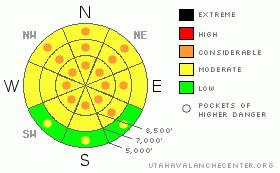
BOTTOM LINE
Danger by aspect and elevation on slopes approaching 35° or steeper.
(click HERE for tomorrow's danger rating)
|
Danger Rose Tutorial
|
There's a MODERATE danger in the backcountry, and dangerous avalanche conditions exist on some slopes steeper than about 35 degrees in the region. The danger is higher in areas that received significant snowfall on Monday, including the western slopes of the Southern Bear River Range and the Wellsville Mountains. In these areas there are pockets with a CONSIDERABLE danger, and you could probably trigger dangerous wind slab and/or persistent slab avalanches on steep drifted slopes. The danger will increase and become more widespread with continued west winds or additional significant snowfall. The danger is lower in the Central Bear River Range where much less snow fell on Monday, but triggered avalanches are possible on some steep drifted slopes, and there is a MODERATE danger, mainly in exposed lee terrain at upper and mid-elevations.
You'll find safer conditions today in lower angled or normally sunny terrain. Use conservative decision making, careful route finding and, as always, continue to use good travel habits.... |
|
|
CURRENT CONDITIONS |

|
The Central Bear River Mountains were mostly left out of Monday's storm that dropped a couple feet in some areas in the Wasatch Range. The Tony Grove Snotel reported only 3/10s of an inch of water, while the Ben Lomond Peak Snotel above North Ogden reported 4" of water equivalent, (ten times as much). The Wellsville Range in particular and the western slopes of the Southern Bear River Range picked up significantly more snow than the Central Bear Rivers. We found great powder riding conditions yesterday up in Providence Canyon...
West-southwest winds increased significantly overnight, and the CSI Logan Peak weather station reports average wind speeds in the mid twenties with gusts in the 30s this morning. Its 6 degrees at 9700'. |
|
|
RECENT ACTIVITY |

|
There were a few triggered wind slab avalanches and a couple slides releasing on the surface hoar layer in the Central Wasatch Range yesterday. ( Wasatch Advisory)
Locally, no significant avalanches have been reported or observed recently. Yesterday, my party triggered a couple audible collapses or whumphing noises in mid elevation shady terrain. One of these caused shooting cracks in a tell-tail frown a ways uphill of our spooked trail breaker. We also triggered a few quite manageable and harmless dry sluffs or loose snow avalanches. |
|
|
THREAT #1 |

|
| WHERE |
PROBABILITY |
SIZE |
TREND |

|
|
|
|
| |
|
|
Over the next
24
hours.
|
|
|
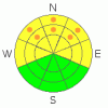
In areas where more than a foot of new snow accumulated on Monday, like in the Wellsville Range and the western slopes of the Southern Bear River Range, dangerous avalanche conditions exist on many slopes steeper than about 35 degrees. Watch for fresh and forming wind slabs in exposed lee terrain. Avoid building cornices and steep slopes with fresh deposits of drifted snow, and stay clear of and out from under obvious or historic avalanche paths. |
|
|
THREAT #2 |

|
| WHERE |
PROBABILITY |
SIZE |
TREND |
|
|
|
|
| |
|
|
Over the next
24
hours.
|
|
|
Monday's new snow overloaded a weak layer consisting of frost crystals or surface hoar in many shady areas, which appears to be quite well preserved under a couple inches of snow from Friday. (photo). This is a growing concern, and the weak layer is likely to become more reactive as the new slab builds and develops more dangerous cohesive properties with winds or additional accumulations in the next couple days...
Slab avalanches stepping down to this layer today could be 1 to 2 feet deep, fairly broad, fast moving and far running.... |
|
|
THREAT #3 |
|
|
| WHERE |
PROBABILITY |
SIZE |
TREND |
|
|
|
|
| |
|
|
Over the next
24
hours.
|
|
|
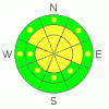
With much less new snow from the weekend and Monday, the danger is lower in the Central Bear River Range. Triggered wind slab avalanches are possible on drifted slopes steeper than about 35 degrees. The danger is higher at upper elevations and on slopes facing northwest through southeast.
The buried weak layer consisting of frost crystals or surface hoar from last week's high pressure system is present in the Central Bear Rivers, but the developing slab is much shallower. Freshly deposited wind slabs could build on slopes plagued by intact and shallowly buried surface hoar. Avoid obvious or suspected drifts on steep slopes, and give large and building cornices lots of room and respect, as these are likely to be fairly sensitive today. |
|
|
MOUNTAIN WEATHER |

|
Snowfall should pick up today as a weak disturbance crosses the region. Another storm will impact the region tomorrow.
Looks like the main energy with this storm will be to our south once again, but we'll probably get a bit more snow. Another storm on a similar track will impact the region over the weekend beginning late Friday, and a moist and unsettled weather pattern should continue into early next week. |
|
|
GENERAL ANNOUNCEMENTS |
Our "Know before You Go" video is available online..... (click HERE to watch it)
The UAC depends on contributions from users like you to support our work. To find out more about how you can support our efforts to continue providing the avalanche forecasting and education that you expect please visit our Friends page.
Your snow and avalanche observations help everyone in the backcountry community. Please let us know what you're seeing by leaving a message at (435-)755-3638 or 1-800-662-4140, or email us at uac@utahavalanchecenter.org. .
This advisory is from the U.S.D.A. Forest Service, which is solely responsible for its content. This advisory describes general avalanche conditions and local variations always occur.
I will update this advisory by around 7:30 Friday morning. |
|
|
This information does not apply to developed ski areas or highways where avalanche control is normally done. This advisory is from the U.S.D.A. Forest Service, which is solely responsible for its content. This advisory describes general avalanche conditions and local variations always occur. |
|
This advisory provided by the USDA Forest Service, in partnership with:
The Friends of the Utah Avalanche Center, Utah Division of State Parks and Recreation, Utah Division of Emergency Management, Salt Lake County, Salt Lake Unified Fire Authority and the friends of the La Sal Avalanche Center. See our Sponsors Page for a complete list. |
