AVALANCHE WATCH »
The risk of an avalanche is expected to increase significantly
but the timing and location are still uncertain. Stay tuned for updates.
|
 |
Notice: We've issued an Avalanche Watch for the Wasatch and Bear River Mountains, including the mountains around Logan. Widespread human triggered shallow slab avalanches as well as scattered natural avalanches occurred on Saturday, and avalanche conditions will be dangerous again today. In addition, substantial water weight in the recent snow and significantly more expected over the next 36 hours may be enough to overload deeply buried weak layers, increasing the probability of deep slab avalanches, especially in areas with a thinner snowpack.
Expert level avalanche training and experience are essential for backcountry travel today. |
|
|
SPECIAL ANNOUNCEMENT |
 |
The Friends of the Utah Avalanche Center and Cache Honda Yamaha invite you to attend an Avalanche Class for Snowmobilers. The class will start Thursday January 29th at 6:30 at CHY (3765 N. Hwy 91, Hyde Park), with an on-the-snow field session on Saturday, January 31st. Cost: $25 per person for both sessions or $10 for Thursday's classroom session only. To register, please contact Cache Honda Yamaha at 563-6291. |
|
|
BOTTOM LINE
Danger by aspect and elevation on slopes approaching 35° or steeper.
(click HERE for tomorrow's danger rating)
|
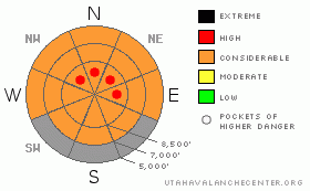
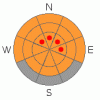
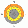
Danger Rose Tutorial
|
There is a CONSIDERABLE danger in the backcountry today. Triggered soft slab avalanches consisting of new or recently accumulated snow are probable on many slopes approaching 35 degrees in steepness. With the danger increasing and becoming more widespread throughout today, I've included pockets with a HIGH danger on northerly facing slopes at upper elevations. Deadly, deep slab avalanches are possible in some areas and the danger is increasing, mainly on slopes with shallow overall snow cover. Loose wet avalanches are still possible on steep lower and mid-elevation slopes with saturated snow.
Use conservative decision making, careful route finding and good travel habits. Expert level avalanche training and experience are essential for backcountry travel today. |
|
|
CURRENT CONDITIONS |

|
The Tony Grove Snotel reports 3+" of water equivalent gain in the last 72 hrs, with 10 inches of heavy snow yesterday and overnight. There's currently 71 inches of total snow on the ground at 8400'.
Expect drastically more heavy new snow as you go up in elevation today. Dangerous avalanche conditions dictate caution, and I plan to avoid and stay clear of steep slopes and obvious or historic avalanche paths and stick to lower angled terrain. |
|
|
RECENT ACTIVITY |

|
Friday afternoon, I noticed a handful of large natural loose wet avalanches in Logan Canyon near Temple Fork and above the Dugway section...Wet avalanches gouging to the ground, and in one case, crossing the river on steep low elevation slopes with saturated, structure-less snow. (1-23-09 photos)
Triggered and some natural avalanches involving heavy moist or drifted new snow were fairly common in the Wasatch Range yesterday. (Wasatch Advisory) No avalanches were reported locally.... |
|
|
THREAT #1 |

|
| WHERE |
PROBABILITY |
SIZE |
TREND |
|
|
|
|
| |
|
|
Over the next
24
hours.
|
|
|
We can expect to trigger soft slab avalanches consisting of new snow on many steep slopes today, and the danger will be rising. On some steep slopes, the heavy new snow from the last three days did not bond very well to underlying sugary or faceted surface snow, and slab avalanches in the 1 to 2 foot deep range are a good possibility. Steep slopes with significant deposits of heavy new or wind-drifted snow will be the most suspect.
Pay attention to obvious signs of instability like natural avalanches, whumphing or shooting cracks in the new snow. |
|
|
THREAT #2 |

|
| WHERE |
PROBABILITY |
SIZE |
TREND |

|
|
|
|
| |
|
|
Over the next
24
hours.
|
|
|
Deep slab avalanches are possible today, and the chances of these deadly monsters reemerging will increase with the added weight of copious new snow we are expecting to get over the next couple days. |
|
|
THREAT #3 |

|
| WHERE |
PROBABILITY |
SIZE |
TREND |
|
|
|
|
| |
|
|
Over the next
24
hours.
|
|
|
We expect continued rain at lower elevations today, with temperatures and the rain/snow line only gradually dropping. Loose wet avalanches are still possible on steep slopes at lower and mid-elevations today. Avoid terrain traps like gullies, cut banks, and steep slopes above or in trees. |
|
|
MOUNTAIN WEATHER |

|
Expect gradually diminishing temperatures and snow densities with another 5 to 7 inches forecast for today...Southwest winds will pick up this afternoon. Snowfall will continue this evening before decreasing late tonight and enother 3 to 5 inches are expected to accumulate at upper elevations.. more snow is likely on Monday.... A drying trend in the weather is expected mid-week. |
|
|
GENERAL ANNOUNCEMENTS |
New*** Click HERE for the online version of the Know Before You Go video.
The Utah Avalanche Center depends on contributions from users like you to support our work....You can support the Utah Avalanche Center and get discount lift tickets to Beaver Mountain (here). All proceeds from sales will support us through the Friends of the Utah Avalanche Center....
The information in this advisory is from the U.S.D.A. Forest Service, which is solely responsible for its content. This advisory describes general avalanche conditions and local variations always occur.
I will update this advisory by 7:30 Monday morning. |
|
|
This information does not apply to developed ski areas or highways where avalanche control is normally done. This advisory is from the U.S.D.A. Forest Service, which is solely responsible for its content. This advisory describes general avalanche conditions and local variations always occur. |
|
This advisory provided by the USDA Forest Service, in partnership with:
The Friends of the Utah Avalanche Center, Utah Division of State Parks and Recreation, Utah Division of Emergency Management, Salt Lake County, Salt Lake Unified Fire Authority and the friends of the La Sal Avalanche Center. See our Sponsors Page for a complete list. |
